
In my previous post I explained why – on some days – cross-country flights from Boulder are only possible by locating and connecting with the prevalent convergence line that often runs parallel to the Front Range of the Rocky Mountains.
Yesterday was another “line-day” even though the line wasn’t nearly as pronounced or critical as on April 27.
Thankfully the line was much further east than on April 27, just a few miles into the foothills, and it was possible to tow right into it. The day provides a great example of why good XC speeds can only be achieved by recognizing and following the best energy lines.
This, of course, is not a new insight. 20x world-champion, Sebastian Kawa, said in his recent interview with Bruno Vassel that “where you fly, i.e., the line you choose, is the most important factor to winning”. In a recent webinar, former US team captain, John Good, compared soaring to running through the woods: “the fastest way is to follow the path” instead of “crushing through the undergrowth”.
Being a trail runner myself, I love John’s example, but I would also say that a runner’s paths through the woods are usually a lot easier to locate than the energy lines through the sky. Successful cross-country soaring therefore often comes down to the art of recognizing and following these paths.
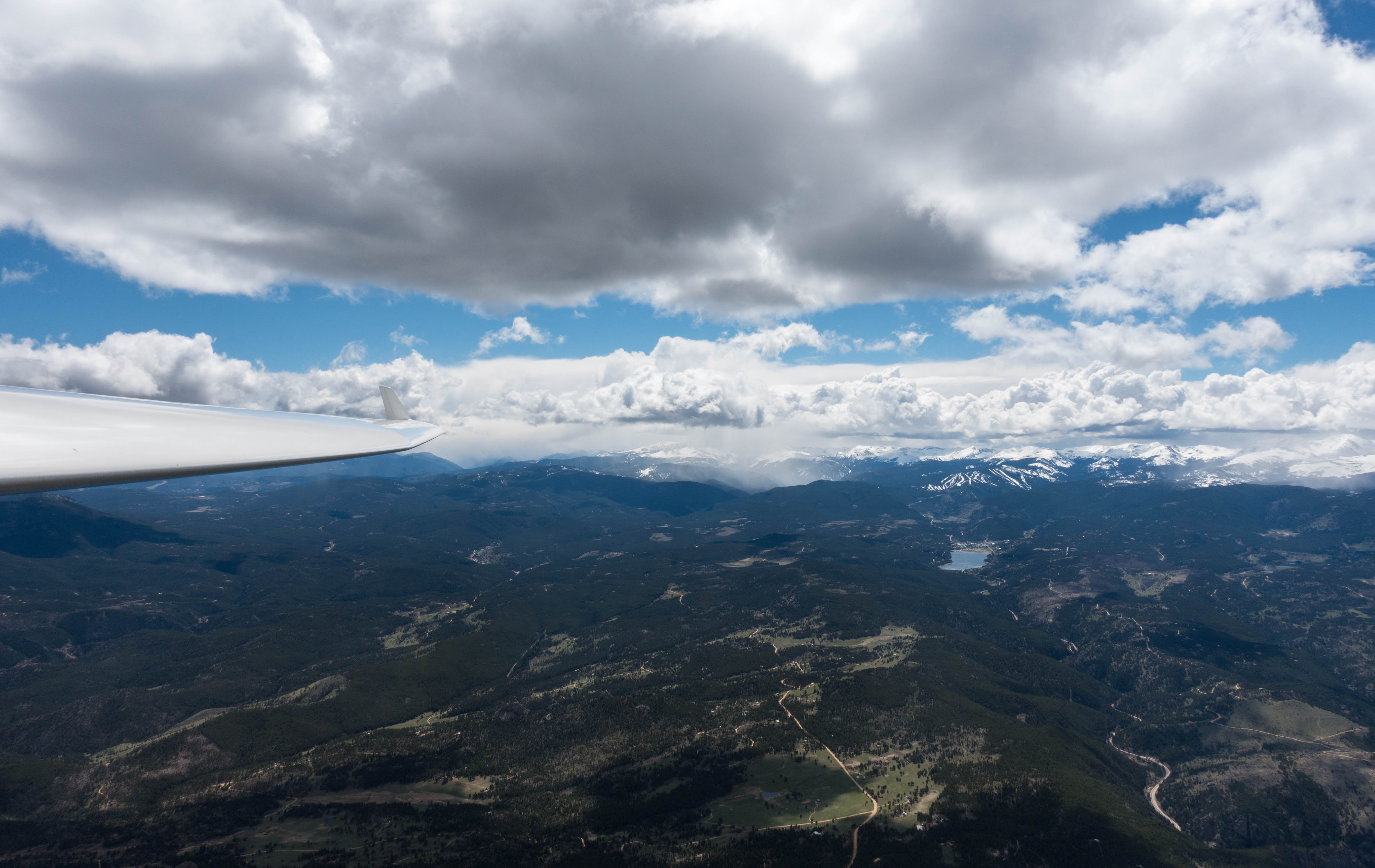
Unlike a well-trodden hiking trail, the path through the sky is – by itself – always invisible. However, on many days clouds can provide excellent markers that, akin to trail blazes, help you find the route even if the trail itself is completely snowed in. And just like trail markers, the identifying cloud markers can sometimes be spaced close together, and sometimes they can be far apart, making it easy to get lost. And sometimes there are no markers at all. Such blue days are the hardest because you are left to using your analysis of the wind, the sun angle, and the terrain, and your imagination of what is happening in the sky, to figure out where the energy lines would most likely be. (However, it’s important to recognize that – unless the air is completely still – they are almost always there.)
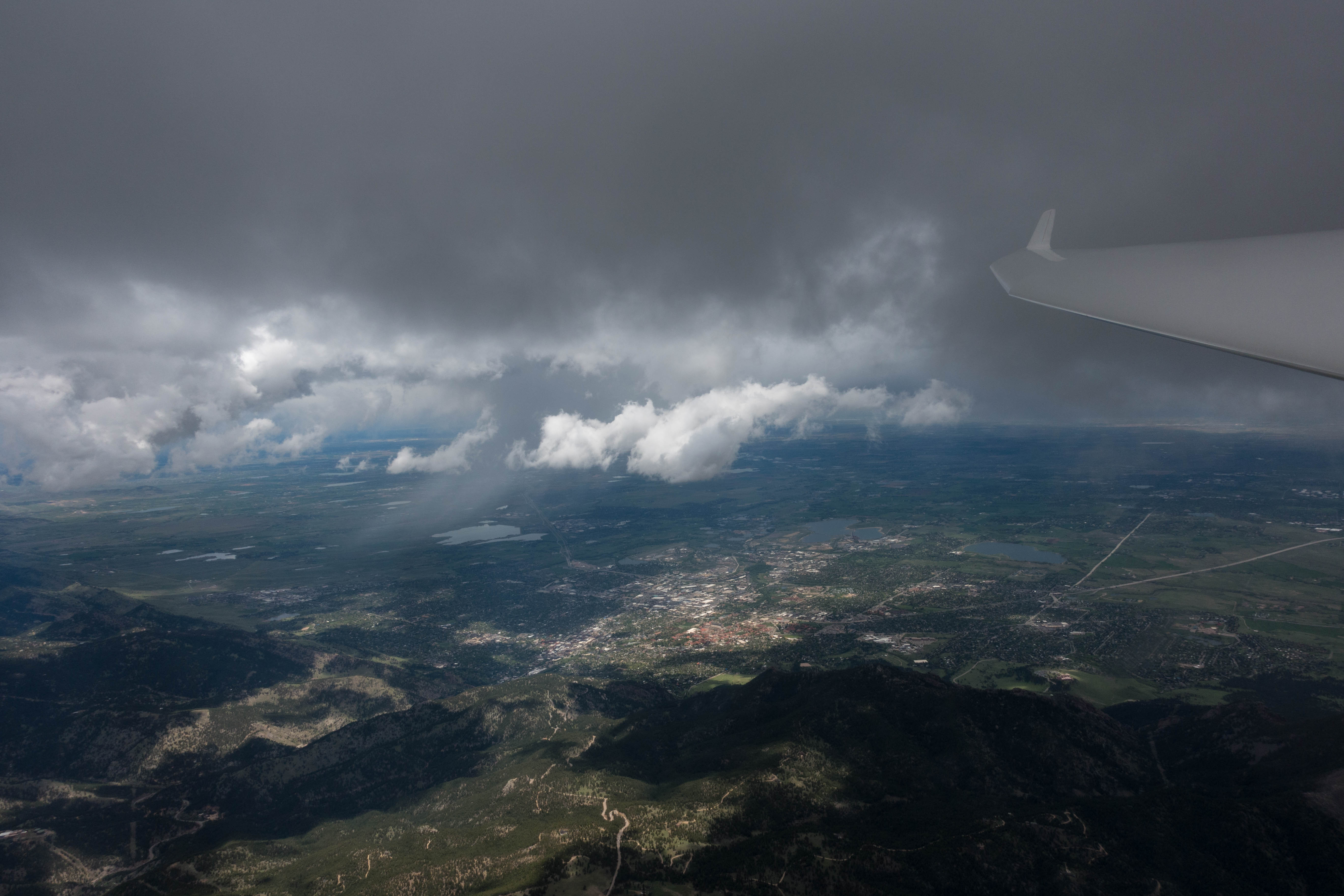
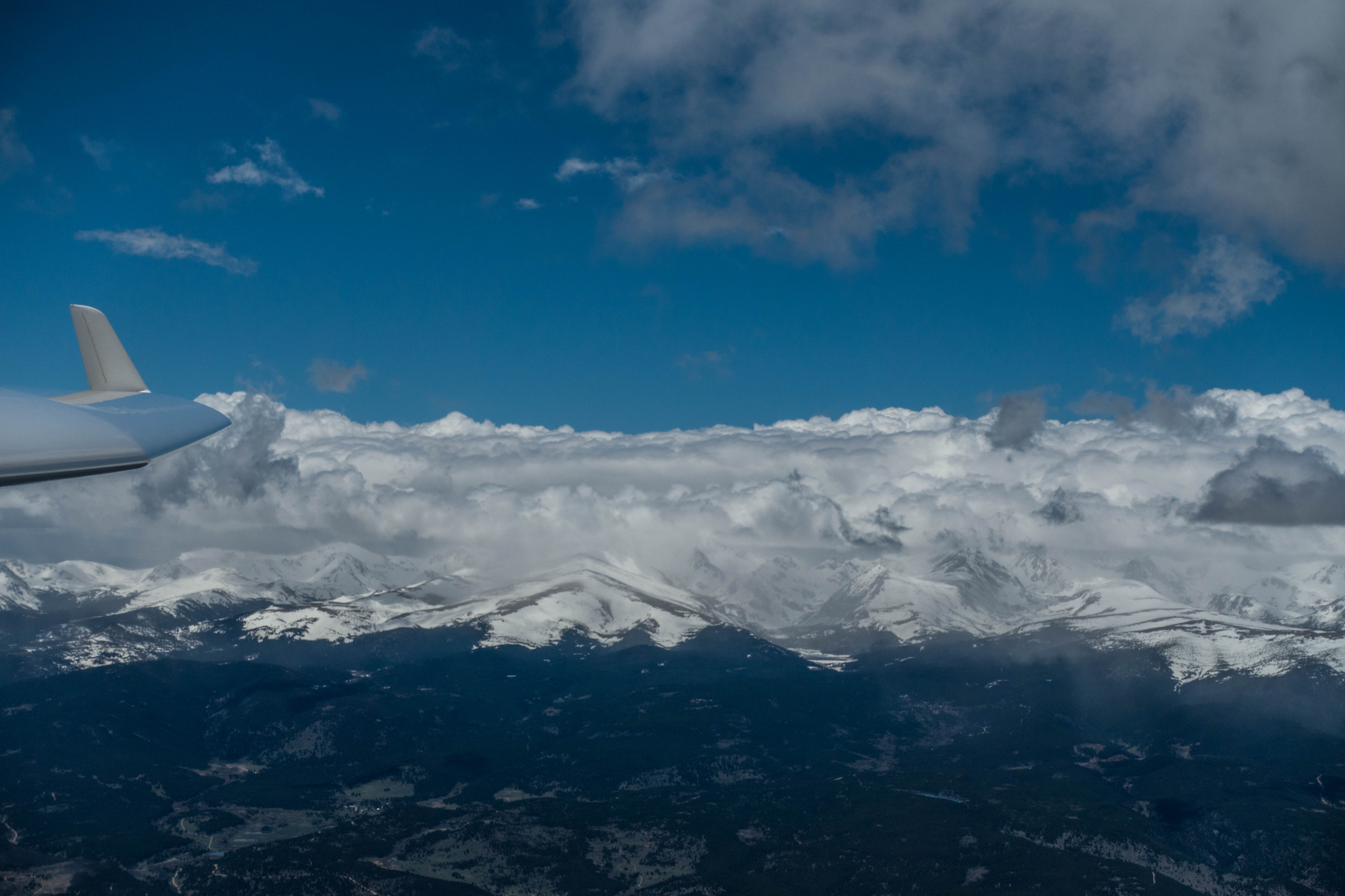
But back to yesterday’s soaring. The screenshot below shows the flight traces of the four Boulder pilots who posted their flights on the OLC web site. The first thing you’ll notice is that each of them tried to follow the energy lines that set up parallel to the Front Range due to westerly winds coming over the mountains and a weaker easterly flow near the ground over the plains. Where these flows came together, i.e. converged, the energy line(s) set up.
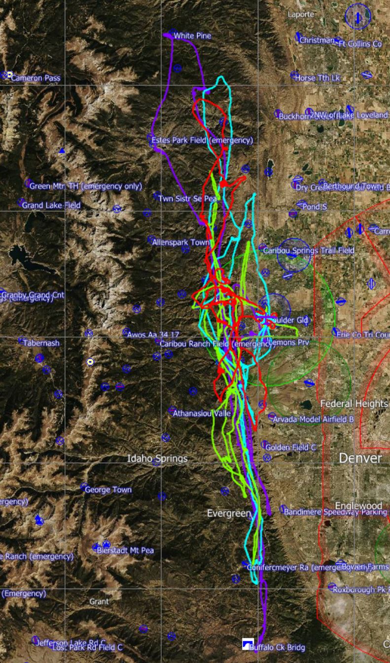
I’m using the plural because there wasn’t only one line. You can see this in the northern half of the chart where there was more than one line that provided lift. I believe that this is due to a weak wave motion of the westerly flow aloft which tends to result in lift lines underneath each wave bar. Consider the drawing in my prior post. I think it is the most likely explanation for this phenomenon. In the southern half of yesterday’s soaring area the line was most distinct and you can see that all pilots flew within the same narrow lift band. (The traces are basically overlapping.) The small east-west variation of the flight tracks here is most likely the result of the line shifting slightly over time and each of the pilots flying there at somewhat different times of the afternoon.
There were a lot of clouds yesterday and for the most part finding and following the line was relatively easy. The most tell-tale sign was the dramatically different height of the cloud bases. Cloud bases to the moister east of the main energy line were much lower than on the drier west side. Curtain clouds were a frequent occurrence marking the edge of the line. It was always critical to stay west – on the dry side – of the curtain. (You can also take a look at this flight from last year for more pictures and narrative about following the convergence.)

The line was at times quite narrow. I.e., you could find very strong lift following along the line but it wasn’t always possible to circle within the lift without falling out of it on one side of the circle. The best strategy was to just slow down to minimum sink speed when flying in strong lift, and to push the nose down wherever the line was broken.
Intense sunshine hitting the foothills in the afternoon also caused clouds to form further west of the main energy line and this could be quite confusing. It was as if some prankster had put up a few erroneous markers in the woods to the side of the trail. If you were tempted to follow such a side trail (as I was two or three times) you would still find lift but it was much weaker than along the main energy line. But even worse, eventually the side trail would end and you would have to fly back to the main energy line. And there you would be punished by having to cross severe sink causing a tremendous loss of height, i.e. potential energy. (This was just like the time lost by a runner who erroneously followed a random animal track and then has to bush-whack their way back to the real path.) Very clearly, the pilots who avoided such temptations and stayed right on the line posted the highest speeds.
You can see that during some portions of my flight I did this better than at other times by looking at the average speeds for each of my four flight segments.
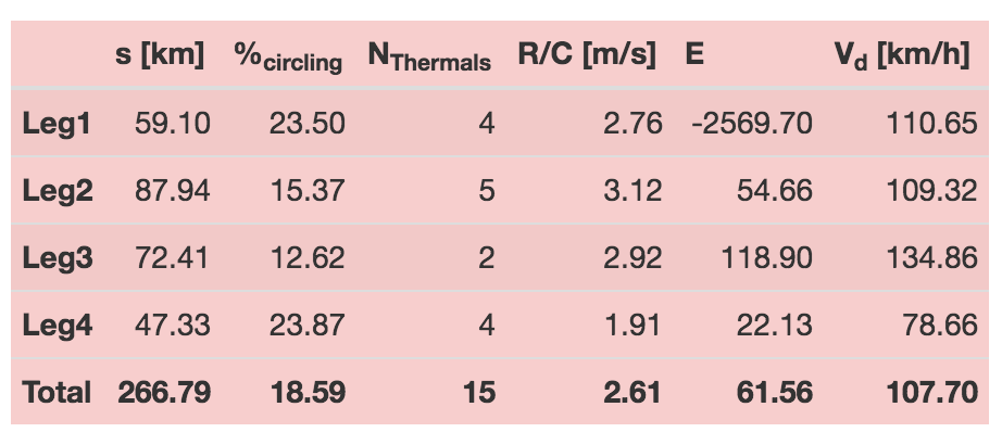
On my first leg my average speed was 110 kph. I did a pretty good job following the line but had started off conservatively and flew at modest airspeeds. I also gained 4,000 feet on this leg so this was a pretty respectable start. I then did a little worse on my second leg. The speed is almost identical but without a net gain in altitude. However, I was now flying into a headwind component. A close look at my flight trace shows one erroneous route deviation where I followed a side track that led me a few miles too far west and eventually caused me to loose more than 2,000 feet to return to the main line. The third leg was my fastest with an average speed of almost 135 kph even with a slight net gain in altitude, showing that the day had great potential. I don’t think there were any blunders during that leg. And then came a disappointing 4th leg with an average speed of only 78kph. Once again I flew a route a little too far west when I lost almost 3,000 feet and was forced to take a rough and uneven climb, only to be tempted once again to try out another line further west, which did not work either. (At this point I should have had learned my lesson!) Without these mistakes I could have posted an average speed of well over 120 kph for the entire flight. PB and CX demonstrated that this was clearly possible.
After completing the 4 speed-league legs and before coming to land, the best line had shifted further east and demonstrated the potential for even higher speeds later in the day when I flew from Lyons to Eldorado Springs, a distance of 30 kilometers, at an average speed of 182 kph while only losing 1,000 feet of altitude. (Unfortunately this leg did not count for the speed league because my altitude was too low.)

Lessons Learned
- If you can recognize the line, stick with it. Don’t be tempted by clouds that make you deviate from the main line. They may just lead into a cul-de-sac and you may have to “bush-whack” your way back to the main path, losing a lot of altitude in the process.
- The line can be narrow. On a few occasions when I tried to circle in 10+ kt lift I found that the line was too narrow to stay in good lift throughout an entire turn.
- Circle as little as possible, ideally not at all. This flows from the above and it requires the following.
- Fly a precise line. Kawa emphasized this in his interview with Bruno Vassel. Especially when the best lift band is narrow, it is extremely important to fly in the right place and not 500 feet too far left or too far right. (You would not want to run through the woods 5 feet to either side of the trail either.) Of course, that is much easier said than done. Observe throughout the flight where the best lift is relative to the clouds and plan/adjust your flight path accordingly for the clouds ahead. If you hit strong sink between clouds (or if there are no clouds), chances are that you are too far left or too far right and need to change direction. Don’t just hold the course and hope for the best. If in doubt, try upwind first, then go downwind.
- Fly at the right speed. Maximize your time in the best lift to fill up the altitude tank as much as possible, and then push through stretches where the line may be broken. This means looking ahead and planning to fly just above stall speed through stretches of best lift, and accelerating before likely stretches of sink.
- Remember the altitude rule for the speed league. After a particularly fast stretch of flight, you must climb back up to altitudes earlier in the flight to make the segment count.