Mountain wave lift is orographic in nature (it is triggered by wind forcing a stable air mass downwards along the lee slope of a mountain), i.e., it forms independent of any convective processes. Obviously this does not preclude the development of thermals on a sunny wave day. (When the sun heats the ground and the ground warms the air above the trigger point, thermals will form whether there is wave above or not.) However, wave and thermals do interfere with one another: it is possible for strong convection to destroy the wave flow; it is possible for the wave flow to strengthen or weaken thermals; and it is even possible for thermals to trigger waves. Why and how?
- Why and how can thermals destroy the wave flow?
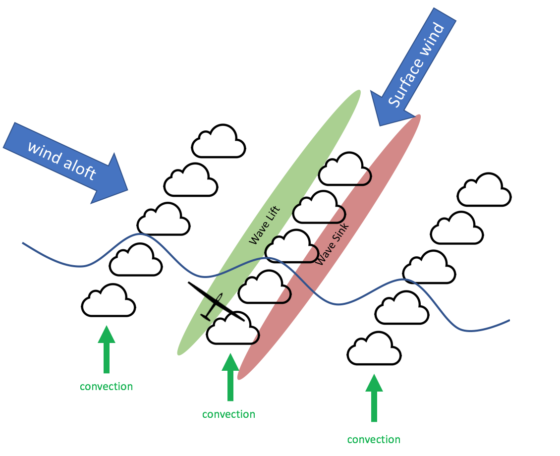
The stronger the solar heating, the stronger the convection. Over the course of a sunny day, the convective layer typically rises higher and higher. If the convection is strong enough, the rising bubbles of air will interfere with the wave flow above. This is typically the case, if the convective layer grows to a depth that exceeds the height of the terrain triggering the wave. It is why smooth wave lift is often best during the winter season when the convection is weakest. In the spring, summer, and fall, wave may be present in the morning until the convection becomes strong enough to destroy the smooth wave flow. Wave lift may then arise again in the evening after the convection has died down.
- Why and how can wave flow strengthen and weaken thermals?
As air flow in a wave oscillates down and up and down (etc.) behind the trigger it warms and cools, and warms again (etc). The temperature changes obviously have an impact on the depth of the convective layer as shown in the graph below.

Where the air flows down, it warms and forms a strong inversion layer. If there are any thermals under this layer, they will be weak and capped by the inversion. In addition, the surface winds in this area will be strong as the air is pushed along the surface by the strong winds aloft (Venturi effect). These winds also have a negative impact on thermal production as the ground does not have enough time to warm the fast moving air.
Where the air flows up again, it cools. Hence, the area directly underneath the top of the wave flow will allow for thermals to rise much higher in the cooler air. In addition, the surface winds in this area will be much lighter, giving the ground much more time to heat the air directly above. On wave days, the best thermals are likely to be found directly underneath the crest of the wave: they are enhanced by the wave.
- Why and how can thermals trigger waves?
A strong thermal pushing into the inversion layer above can even become a trigger for wave above. This is the case if there is a strong wind increase in the stable air mass aloft that forces the stable air over the thermal and back down on the other side. In this case, the lee side of the thermal acts like the lee side of a mountain slope. The stable air warms as it descends on the back side of the thermal, triggering a wave response. E.g., such waves might form perpendicular to thermal cloud streets if the winds aloft are approx. 90 degrees offset from the wind along the surface, and if the cloud streets are spaced in synch with the wavelength. In this case it is possible to climb into smooth wave lift on the upwind side of the cloud street and rise above cloud base along the side of the cloud street in clear air.