
Yesterday, as so often, I began the day by looking at the weather forecast. This is what I saw:
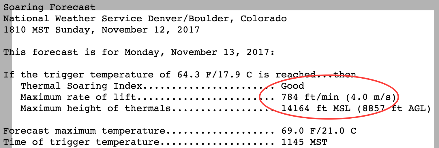
Really? Good thermal soaring with 4 m/s lift up to 14k feet in the middle of November? Sure, it was going to be an unseasonably warm day with highs around 70 degrees F. But 4 m/s seemed way too good to be true. So I took a look at some other sources:

Now that seemed more likely: thermal climb rates of 1.8 kts (0.9 m/s) up to 9,500 feet – more realistic given the season but barely enough to stay up in a glider with a minimum sink rate of ~1.5 kts.
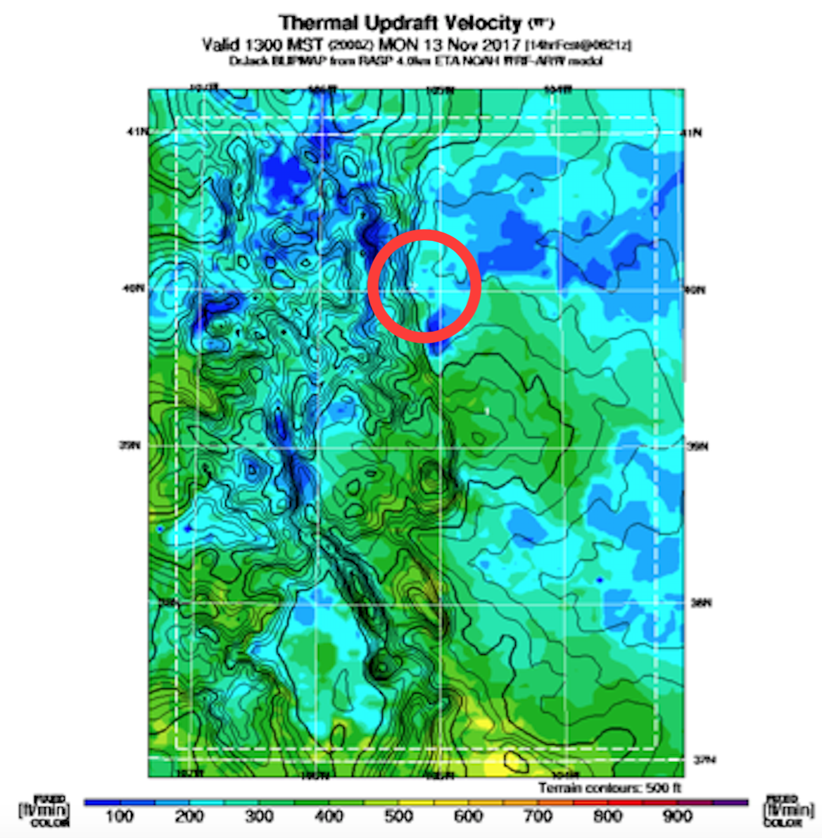
The Thermal Updraft Velocity chart provided by soarbfss.org was just slightly more optimistic than topmeteo.com about the thermal projections: max. climb rates between 200 and 300 feet/minute (1 – 1.5 m/s) with the strongest updrafts just south of Boulder (over the Flatirons).
Which of these thermal forecasts should I believe?
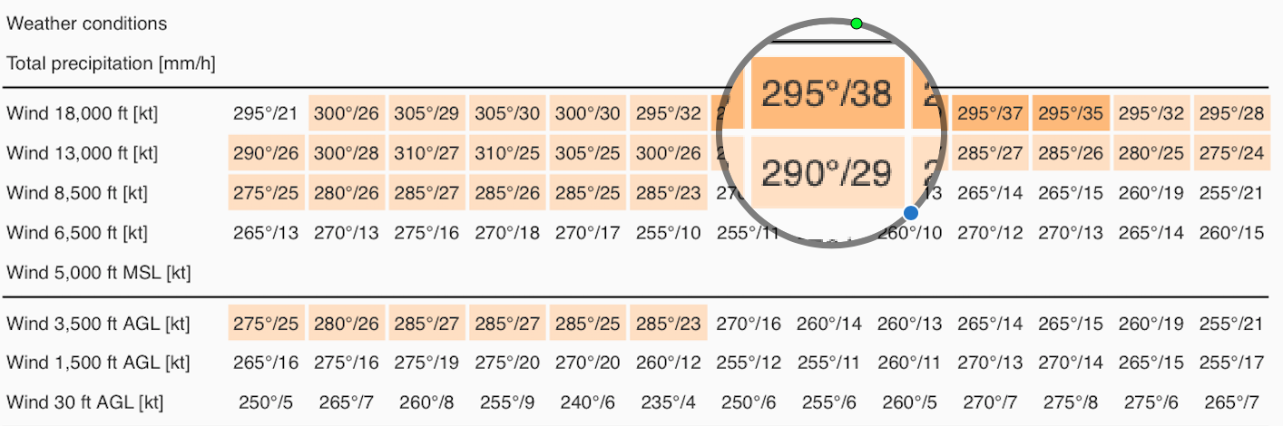
And if thermals wouldn’t work, would there be wave? The wind forecast looked fairly favorable: 29 kts from WNW at 13,000 feet increasing in strength to 38 kts at 18,000 feet with no change in direction.
The cross-section chart for Boulder suggested a strong primary (climb rates of 5 m/s and more) and a weak secondary (climb rates around 1 m/s). The main problem with that outlook is that the secondary would be too weak to climb in, and getting into the primary would require a very long and high tow deep into the mountains crossing through the area of sink between the secondary and the primary.
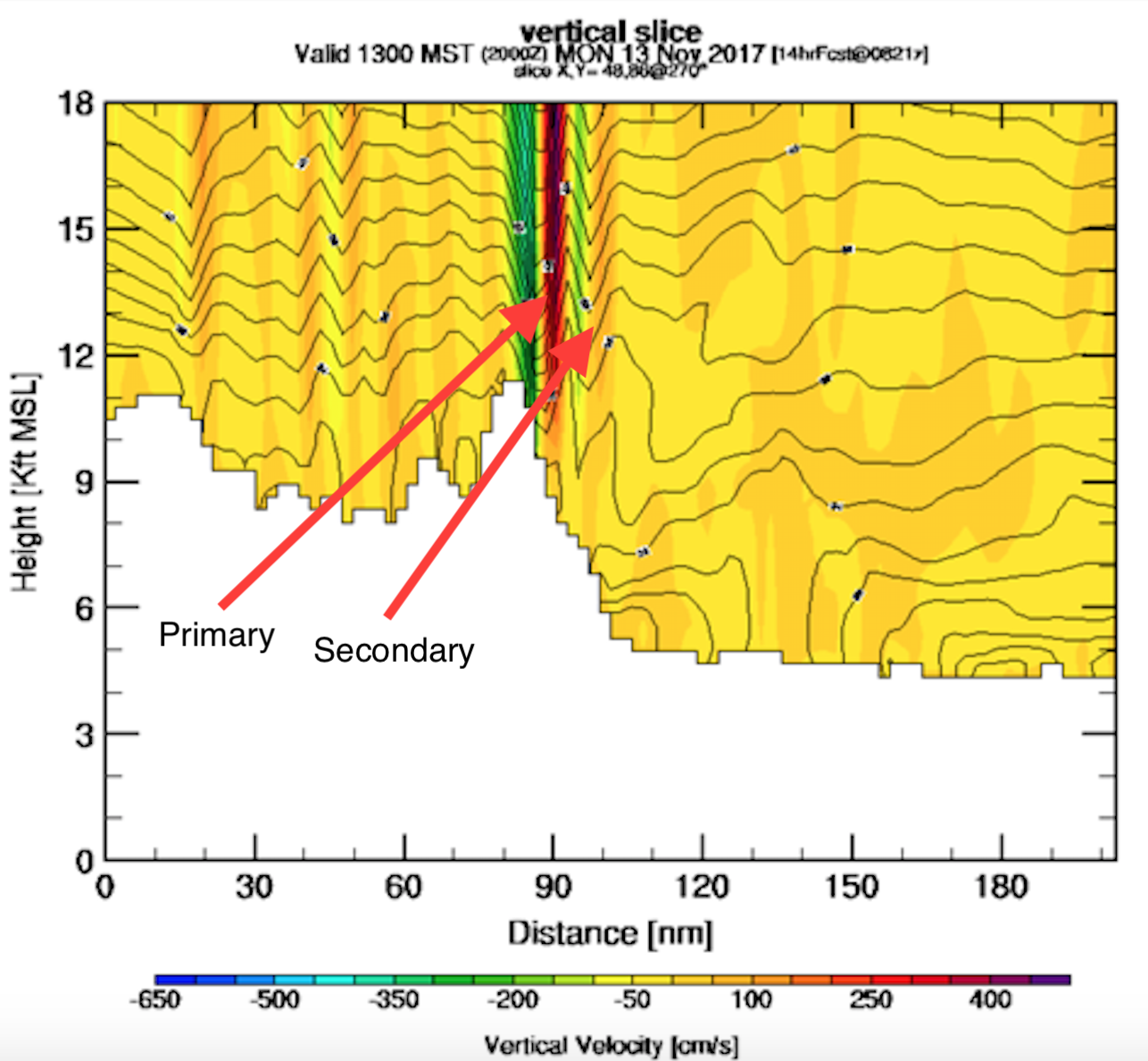
The sounding for Boulder confirmed the wind forecast but did not show the presence of a stable layer at the relevant altitude (between 11k and 15k feet – the height of the Continental Divide that would trigger the wave). The theory says that wave will not form without a stable layer around the tops of the mountains because only a stable airmass will have the tendency to bounce back after it is forced to descend and warm up on the lee side.
The wide gap between the temperature line (red) and the dew point line (blue) suggested blue skies (no clouds) at all altitudes.

The National Weather Service (NWS) was even more pessimistic than these charts suggested:
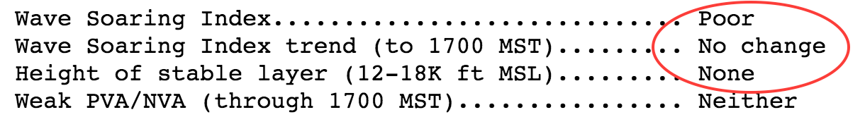
So the usual question arose: do I go, or do I stay? The NWS said there would be great thermals but I did not believe their projections. And despite favorable winds aloft, none of the wave forecasts looked particularly promising.
So, what did I do?

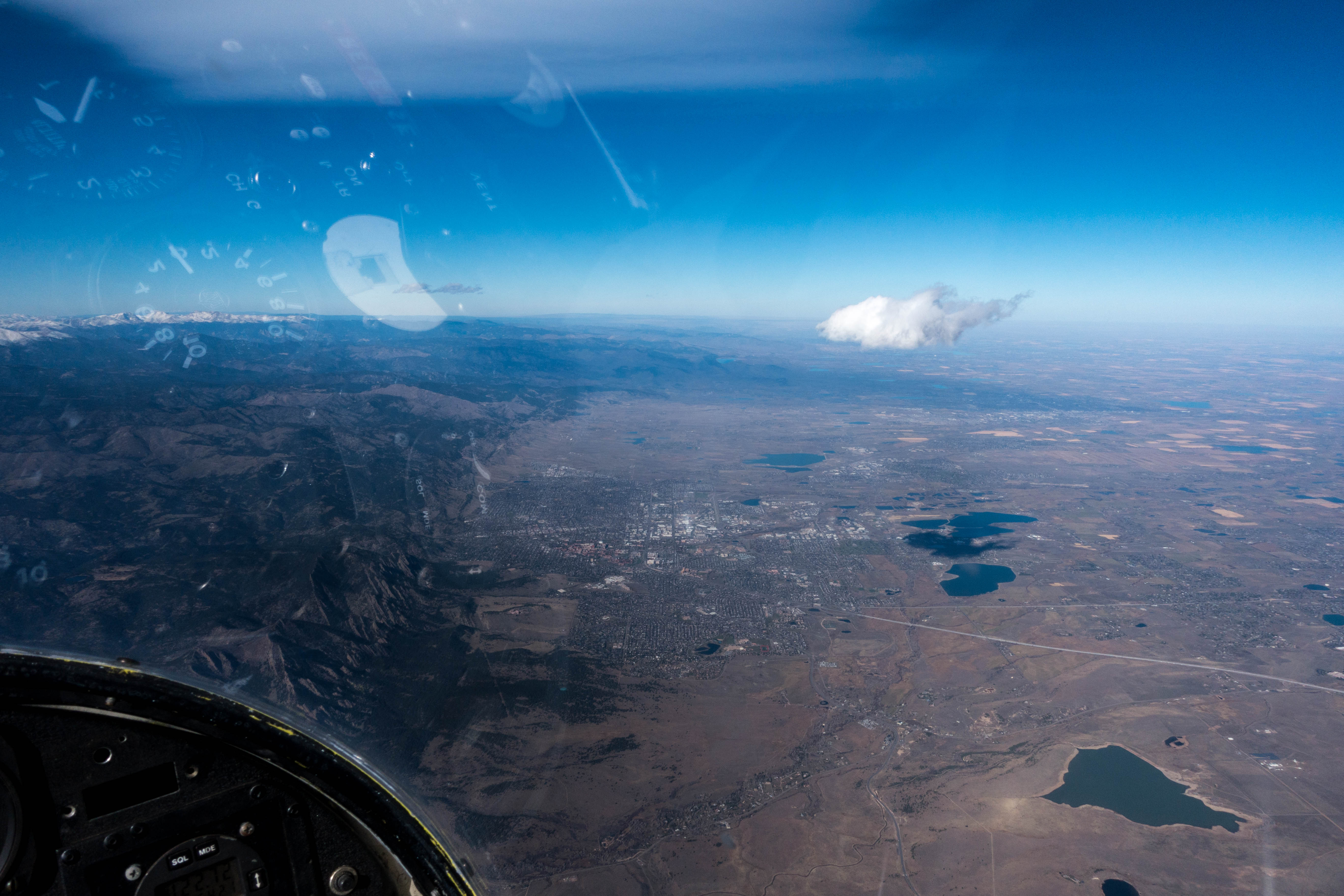
I went. Why? Not because I suddenly thought the NWS’s amazing thermal forecast of 4 m/s might be true after all but because I looked at the sky: there was a small, but beautifully formed, lenticular cloud standing right above Boulder. There were also some small rotor clouds. These were clear signs of wave.
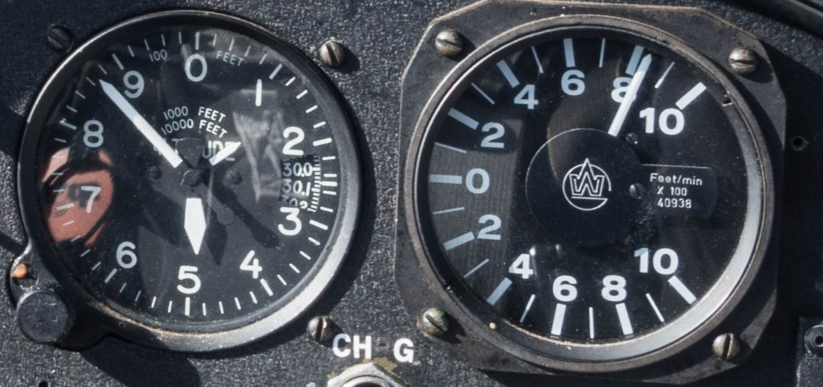
I prepared the “Tin Can” (aka the Schweitzer 1-34), installed my new toy (an Oudie IGC flight computer), checked the oxygen level in the tank and off I went.
Takeoff was easy with a few knots of wind from the east on the ground. That quickly changed at about 1,000 feet AGL when the wind direction switched to the West and the ride through the rotor began. The tow was very bumpy, frequently requiring full control deflections, but I didn’t find it too hard to follow right behind the towplane. Only a few times did I have to correct for a developing slack line.
At just around 9,000 feet MSL we entered the first strong rotor climb just at the entrance to the Left Hand Canyon. After the lift held out for several seconds I released without hesitation (that’s good because at times I waver and stay on for much longer than really necessary).
The wind was quite strong and I knew I had to stay in the area of lift, otherwise I might drift back into sink and end up on the ground again in no time. That’s were the moving map from the Oudie came in extremely handy. The flight trace showed where I was climbing and where I was sinking and all I really had to do was stay more or less stationary to the ground to remain in an area of overall lift. It was rough with short upward bursts being followed by short downward bursts, but overall it went up at a good clip. Within a few minutes I climbed through 10,000 feet, 11,000, then 12,000. Suddenly the air went still and I had reached the laminar flow. The wild high and low beeps from the acoustic vario were now replaced by a happy sound with a constant pitch. Initially the climb rate was not particularly strong but it was consistent and smooth. I moved the trim back to reduce the speed to just over 40 mph and flew in shallow S-turns into the wind, maintaining my position over the ground.
Whenever the climb rate decreased I would first probe into the wind to see if the lift would strengthen and if that did not work I would just let the plane drift back and invariable the climb rate improved again. It was actually quite simple and I just did what the theory of wave flying had taught me to do. Once I had climbed above 14,000 feet I began to explore along the wave bar and just as I had expected, I was able to continue to climb as I began to fly north, parallel to the mountain range which was about 16-18 miles to the west.
I looked into the direction of the wind to identify as well as possible where along the mountain range the particular streamline I was flying in had been triggered so that I could follow the topography and anticipate potential shifts in the location of the best areas of lift as I moved north or south.
I also noticed that I had to adjust the crab angle based on the speed I was flying at: the faster I would fly the less of a crab angle was needed to stay in the best zone of lift and when I slowed down I had to move the nose towards the wind again. It was actually all surprisingly easy and I even understood why some pilots think that wave flying can be a bit boring.
Within no time at all I was at 17,000 feet and the climb rate actually kept improving. I had not called the Denver Center to request the opening of the wave window so I had to stay below 18,000 feet. I increased the airspeed to 100 mph (when the Schweitzer’s sink rate is 3 meters per second) and I was still climbing at 2 m/s. Also, the faster I flew the colder it got. The cockpit of the Tin Can is not exactly well insulated from the outside and while the sun was shining the outside temperature was well below zero.
So I pulled the airbrakes and slowed down. Now I had a better way to manage my altitude without freezing my toes off. At slow speeds the plane climbed even with the airbrakes fully extended. But I just had to speed up a little bit to force to plane to descend.
Once I had figured it out I kept yo-yoing along the foothills between White Ranch Park to the south and Lyons to the north. On my second leg flying south over the Flatirons I looked out to the left and saw a Boing 737 about 2-3 miles ahead to the southeast and about 2000 feet below. It was climbing in westerly direction and definitely getting closer. I checked that my transponder was still on (which it was) and wondered why ATC had not kept us further apart. While we were certainly not in danger of colliding I still felt this was too close for comfort, so I held my position for 30 seconds or so until the jet had passed before I continued my flight to the south.
After about an hour above 17,000 feet I was getting uncomfortably cold despite flying a good amount with open spoilers, so I decided it was better to return to the airfield. I flew into the wind until I was right in the middle of the sink between the primary and the secondary wave and used it as a downward elevator. It was fun watching the altimeter quickly turn backwards and the ground coming closer while still flying in perfectly smooth air.

Remembering that I would have to return to a more turbulent zone, I was about to pack away my camera when – at about 13,000 feet – I got still surprised by the sudden violent jolt upon reentering the rotor. Despite being strapped in fairly tightly, my head hit the top of the canopy; my Oudie’s suction cup gave way and the Oudie as well as my camera flew through the cockpit. I felt thankful for the sturdiness of the sailplane and that I didn’t get hit by anything.
The turbulence stayed with me all the way to the ground. Remembering my prior experience with massive sink in the landing pattern, I made sure to arrive over the airport with ample height. I flew a few circles to get rid of excessive altitude and took note of the distribution of lift and sink near the airfield. I entered the pattern at about 1,600 feet AGL and stayed high along the downwind leg before flying a steep and fast final approach. As expected, conditions smoothened considerably at about 30 feet above the ground and the landing was gentle and right on target.
During my flight I had stayed in the secondary wave the entire time and it provided great and consistent lift of up to 10kts (5m/s). Two other Boulder pilots penetrated into the primary where the lift was probably even stronger. Their flights are here and here. A third pilot tried to get into the primary but reverted back to the secondary when his height evaporated during the attempt. His flight is here. My northern and southern turn points were at locations where I felt the lift getting weaker and I wasn’t confident about continuing given the increasing distance to the airfield. The other pilots proved that the wave lift extended much further north and south but you had to adjust the flight path.
Lessons Learned
- Read the weather forecast but don’t trust it. It is no substitute for looking out the window and forming your own judgement. [Especially the NWS forecast was completely off: there were no thermals to speak of (NWS had predicted thermal lift of 4 m/s); however, wave conditions turned out to be excellent (NWS had predicted “poor”).]
- The wave flying theory really works in practice. Yesterday was actually very easy, I’m wondering if it was unusually easy.
- Seeing my flight trace on the moving map is invaluable. My new toy (Oudie) worked great but it needs a better mount (which I ordered already). The suction cup does not hold up to turbulence (and it probably isn’t great for the canopy either).
- Pack your stuff away before beginning to descend. I was already half-way down and got surprised by the violent re-entry into the rotor zone.
- Dress even more warmly. Warmer gloves and chemical foot warmers in my hiking boots would have been great. It was 22 degrees C in Boulder, 0 degrees C at 12,000 feet, and -15 degrees C at 18,000 feet. It could have been much colder. Also: the faster you fly the colder it gets.
- Keep a good lookout, even with a transponder. Commercial jets taking off from Denver towards the West will still be significantly lower than 18,000 feet over the foothills.
- Where do the (few) clouds come from? If you see a few rotor clouds even though the sounding suggests there should not be any because the air is so dry, they are likely fueled by the moisture of one of the lakes in the foothills.
- Experiment more when you think you’re at the end of a wave bar. A slight change in course direction would have allowed greater distances.