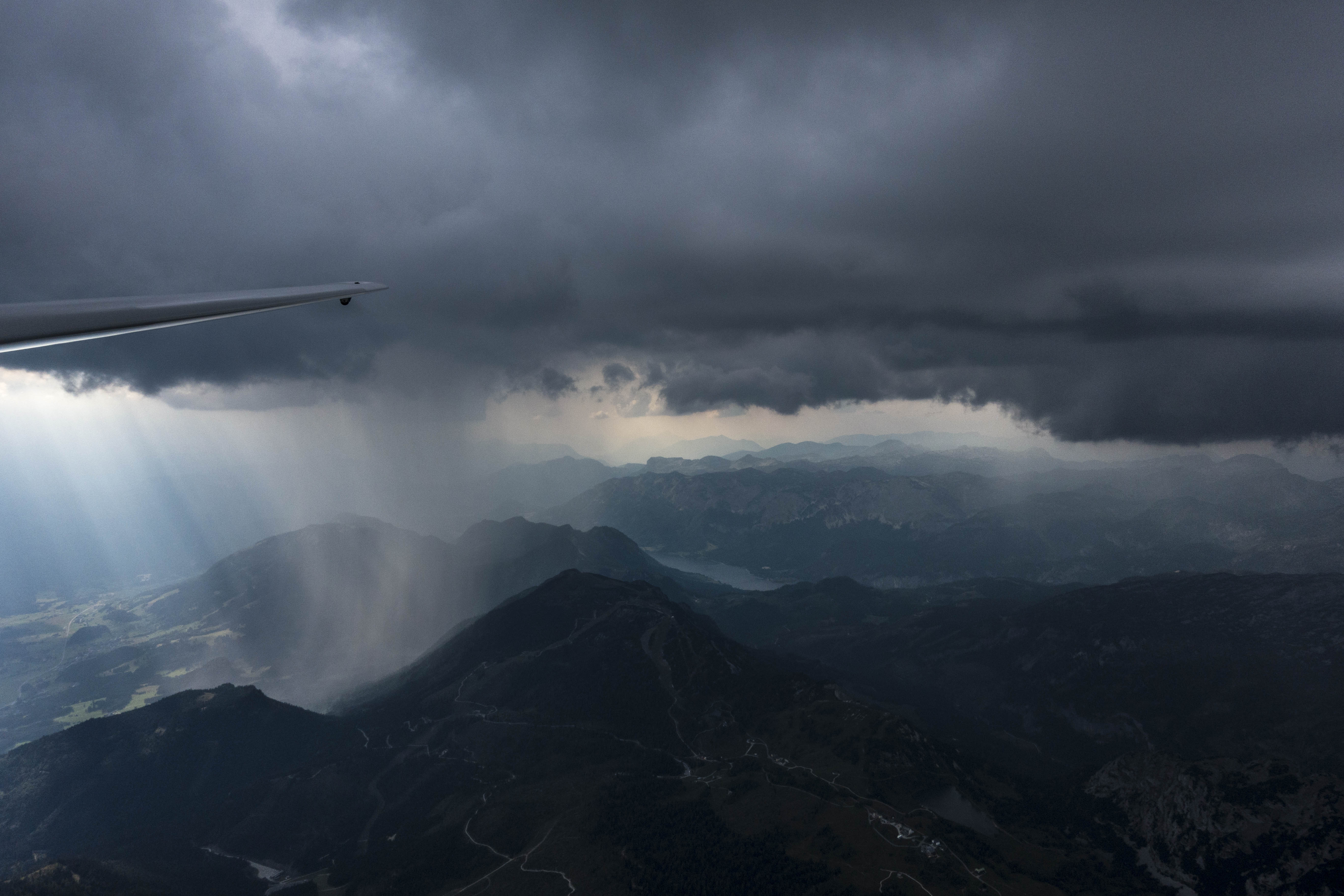
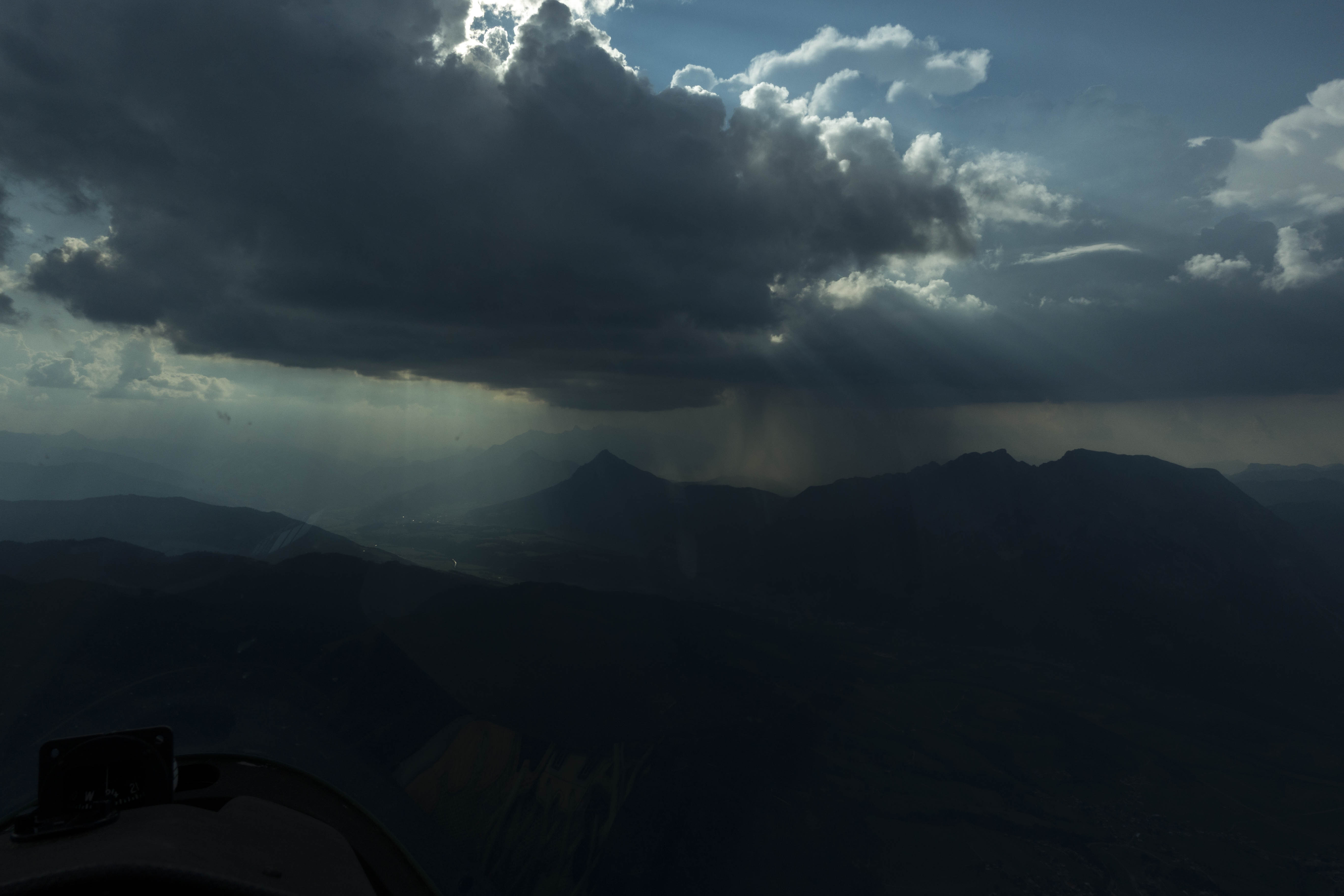
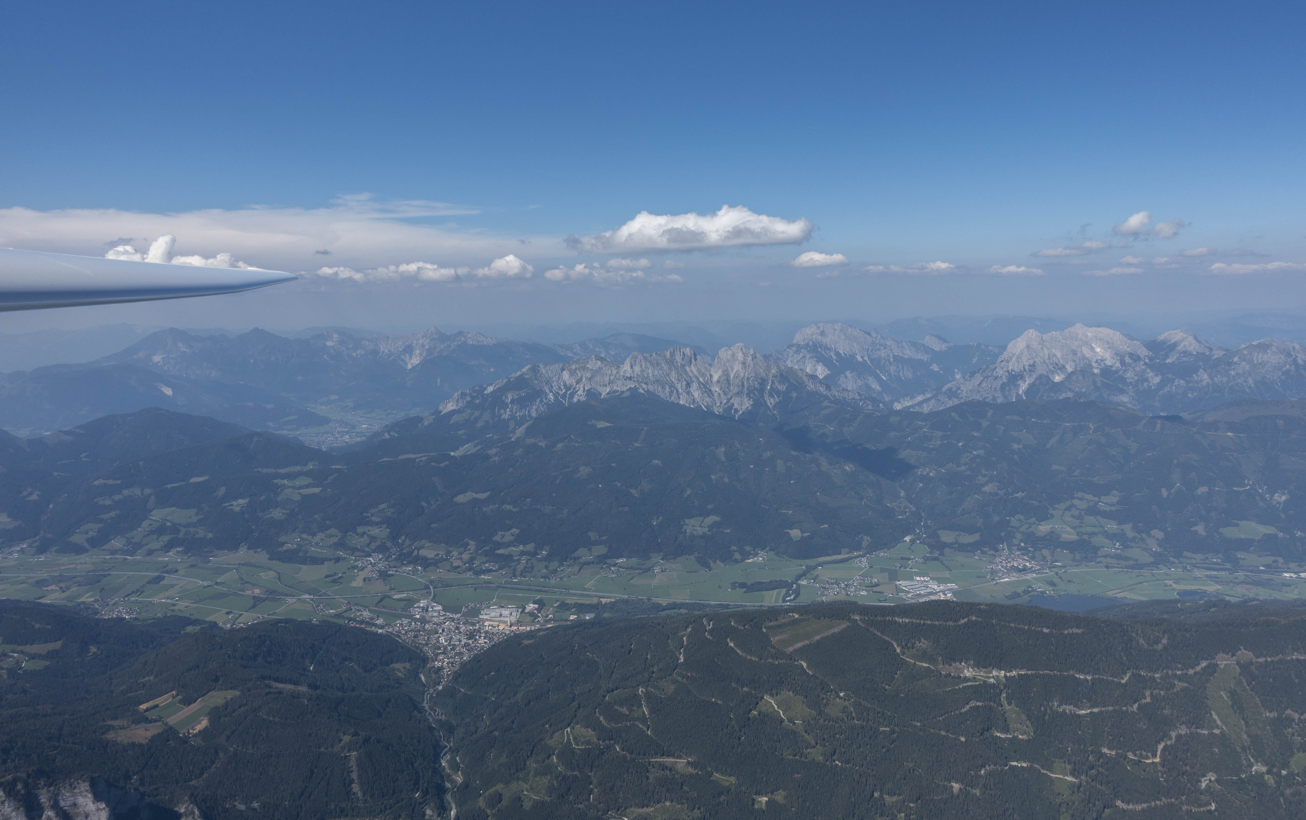
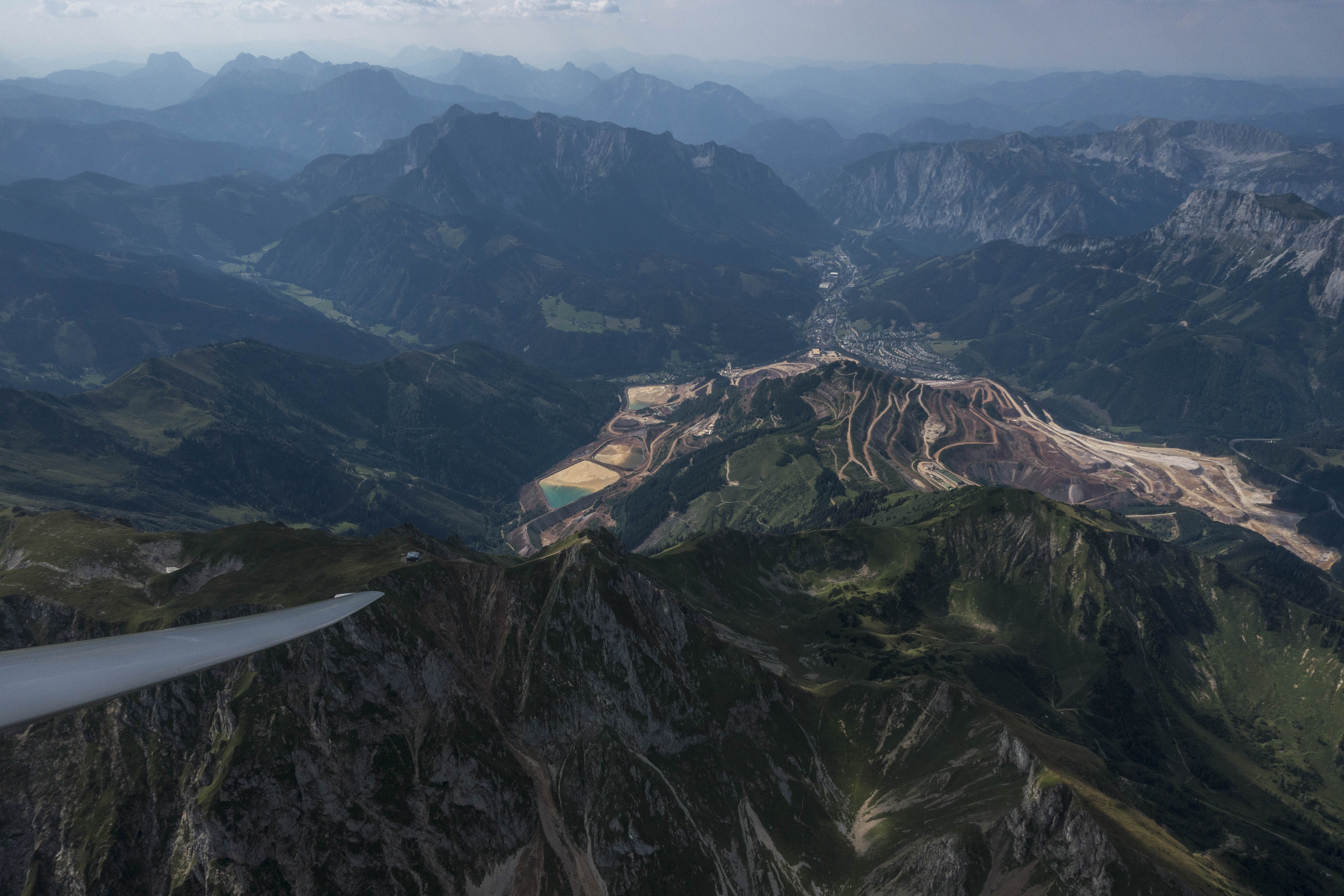
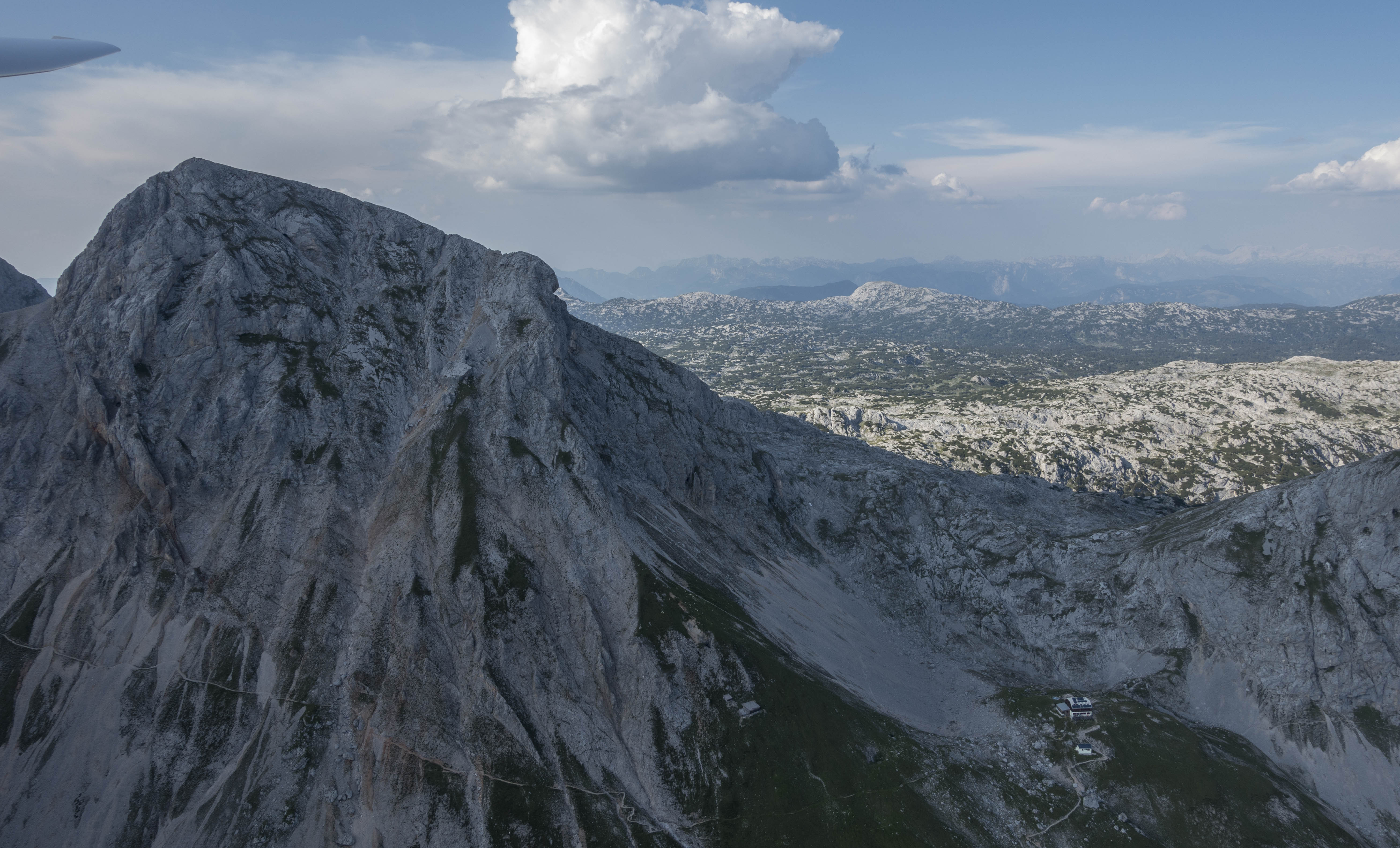
Lift and rain are often found in close proximity to each other. Very pretty scenery north of the Enns Valley.
On August 21/22 I earned my Austrian add-on license to fly self-starting gliders (with the aid of a built-in propeller engine). This took 14 takeoffs on day one and another 11 takeoffs on day 2 for the required minimum of 10 flights with an instructor and 15 solo flights. All of these flights were in a Falke SF25c motor glider – with a glide ratio of less than 1:20 not exactly the most efficient machine…
Once in a while it is nice to fly a lot of patterns – you get really proficient at takeoffs and landings. Being able to confidently land a glider again and again on the same spot and at the absolute minimum speed is definitely a useful skill to have. After completing 11 flights on day 2 in just one hour and a half I had the entire afternoon open to actually go soaring on what looked like perhaps one of the last good thermal days of the season.
Rain seems quicker to fall from cu’s in the Alps (compared to the Western US) – possibly a consequence of a higher moisture content. Also, virga are largely unheard of. If it rains, it rains.
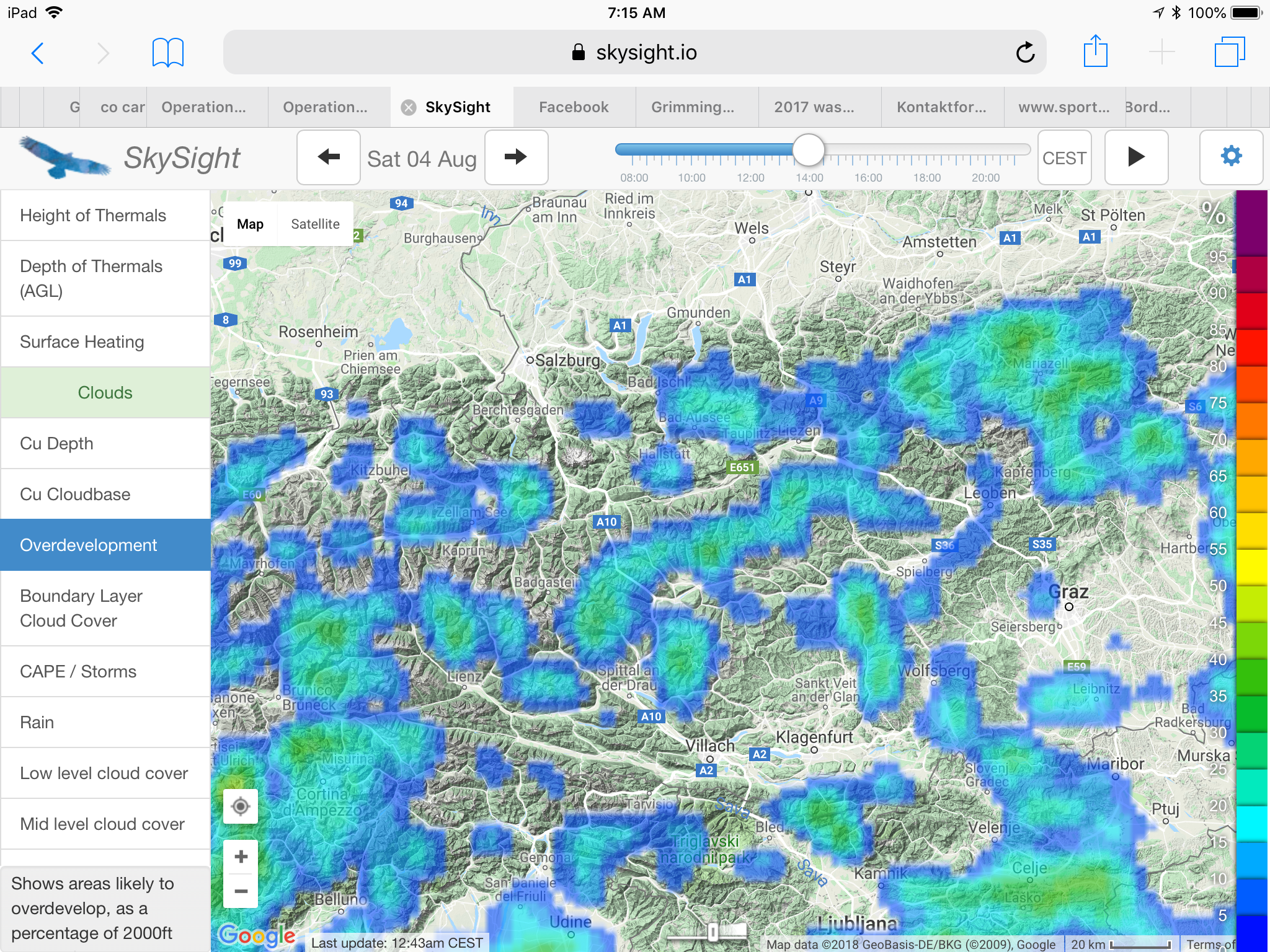
I had no glider reserved and was lucky that the club’s DG 1001 was available. The air mass looked quite unstable with a substantial risk of overdevelopment so I decided that I wouldn’t venture much beyond glide range of the airport and keep a good eye on the weather.
Once again I released above the trusted Karlspitz. To my great surprise there was no lift to be had above its ridge lines. After trying for several minutes I headed under the cloud above the next ridge. Six minutes later I had climbed 3,000 feet and was just below cloud base, at 2,900m MSL.
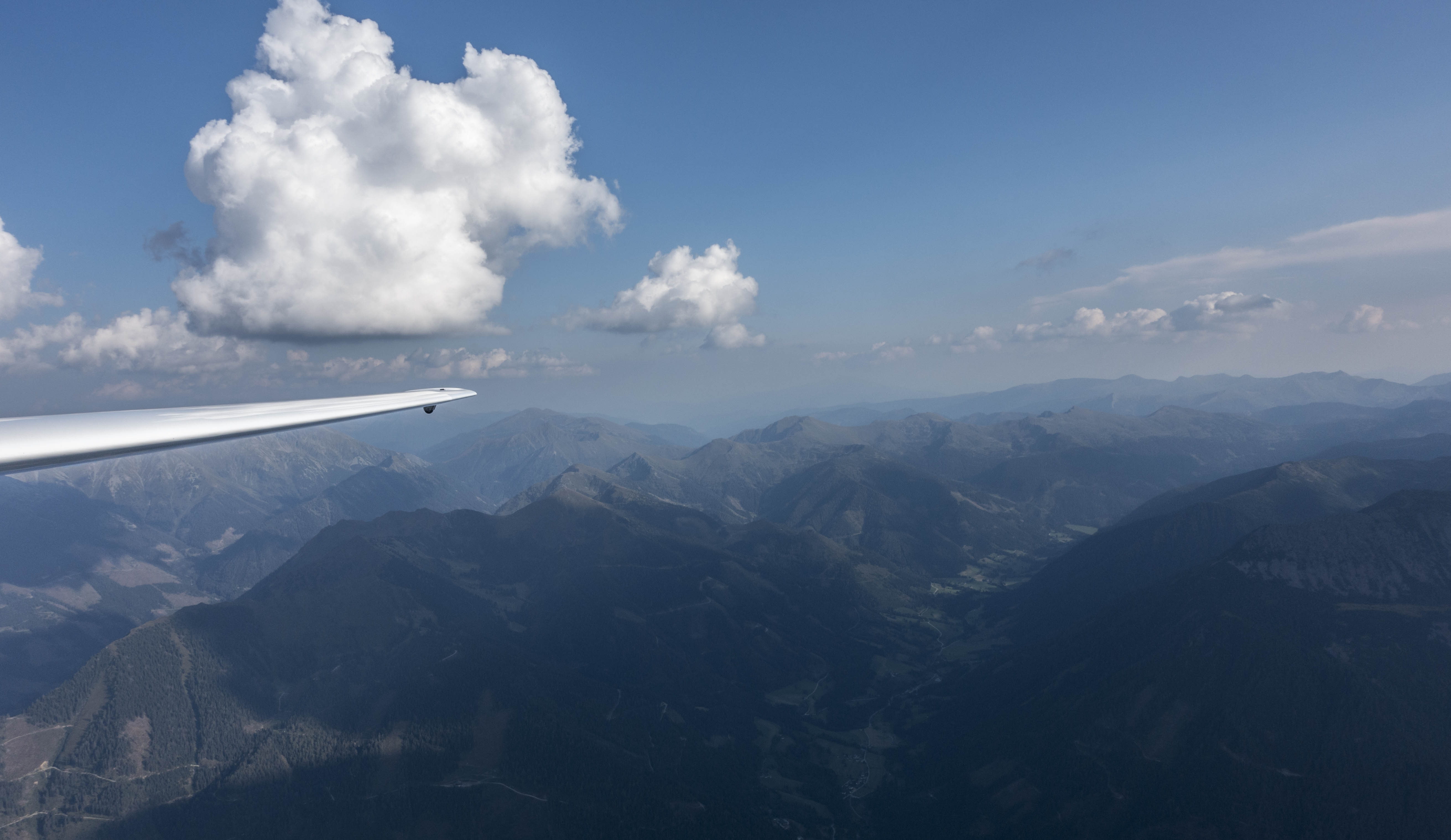
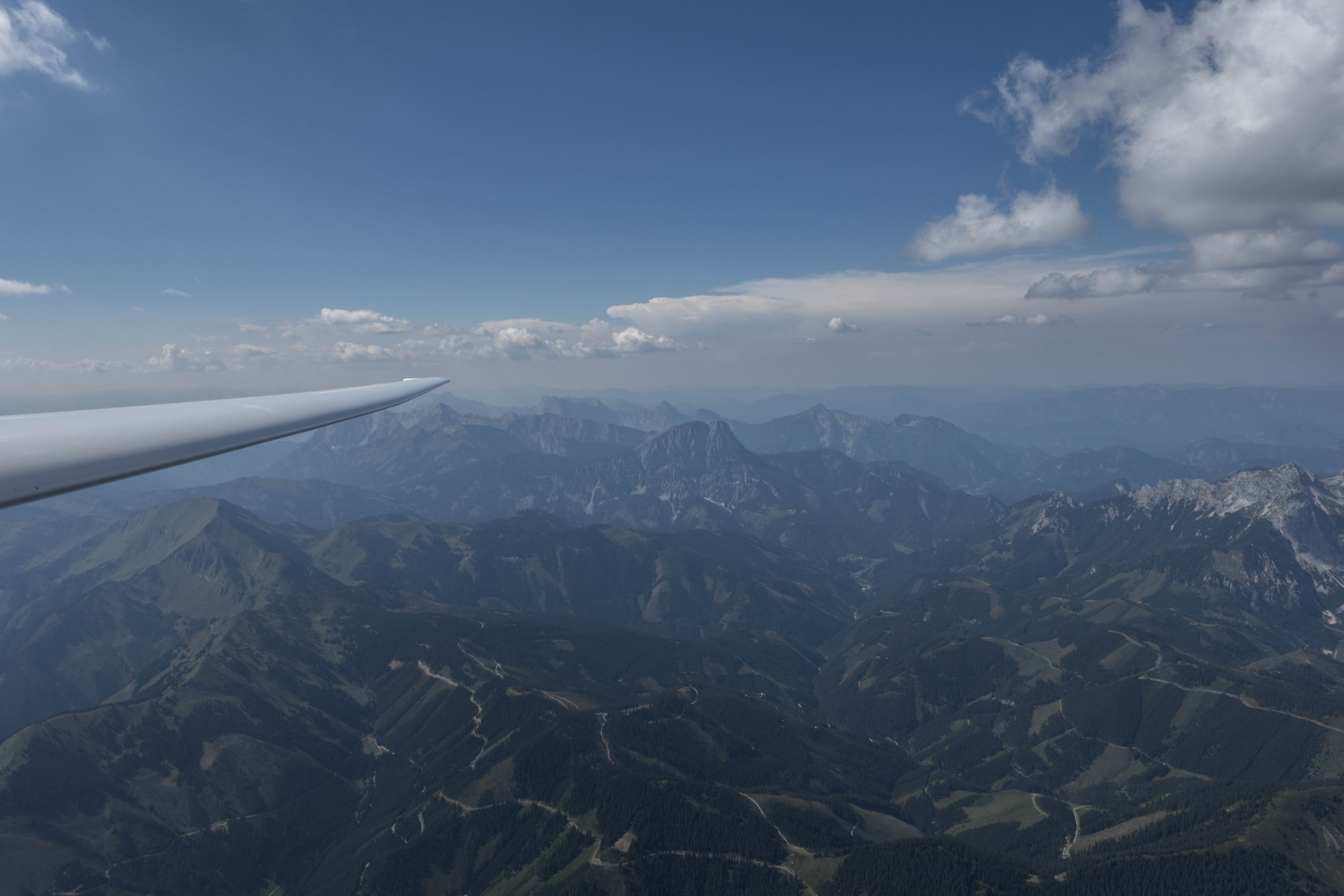
A lot of blue sky to the south early in the flight while over-development appeared quickly to the north.
I headed west towards Schladming but could not find any lift above the next two ridges. A towering thundercloud enveloped Dachstein, on the other side of the valley, approx. 15km away. I suspected that it sucked all the available energy in its direction, leaving nothing for me to climb in.
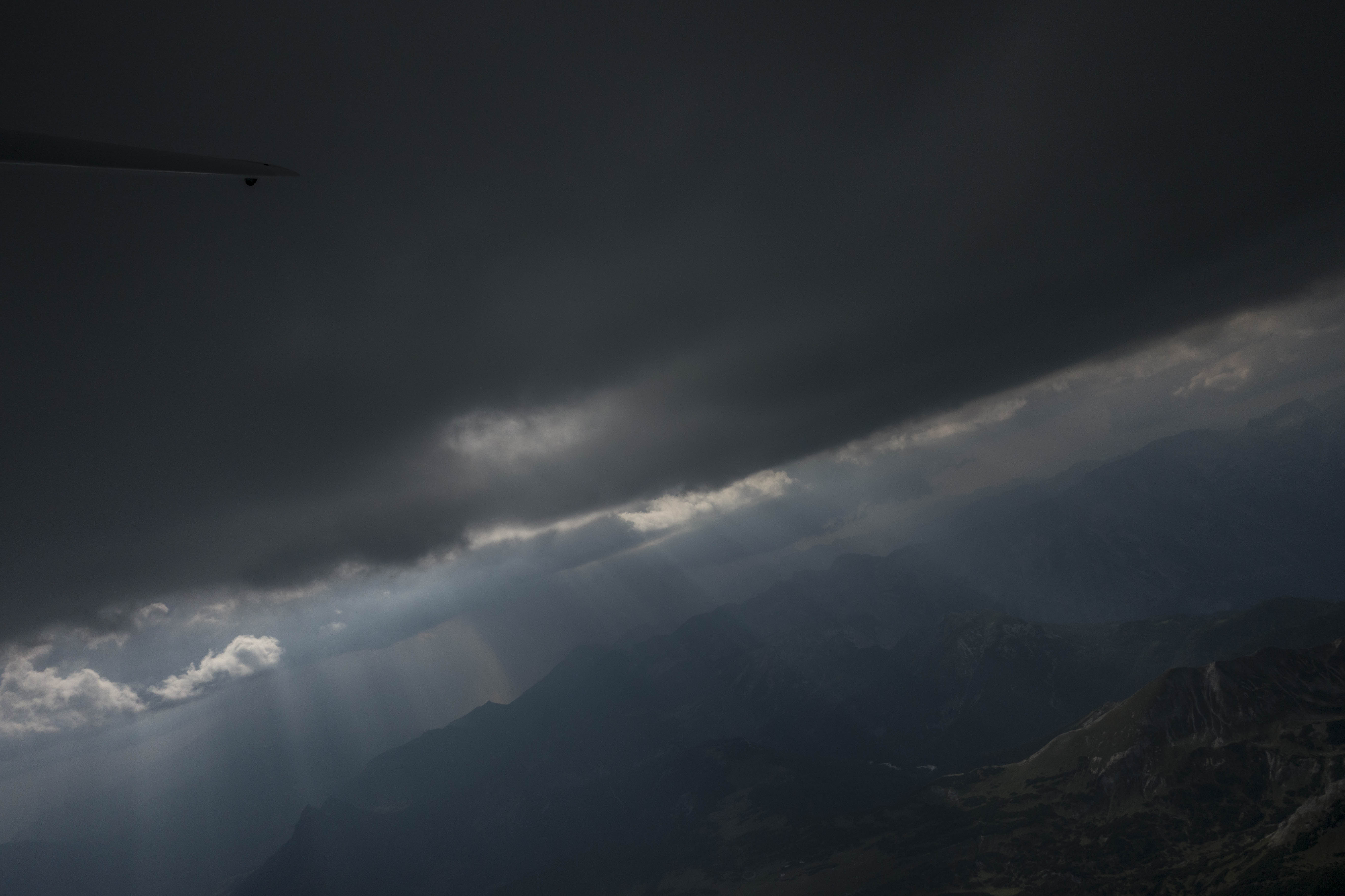
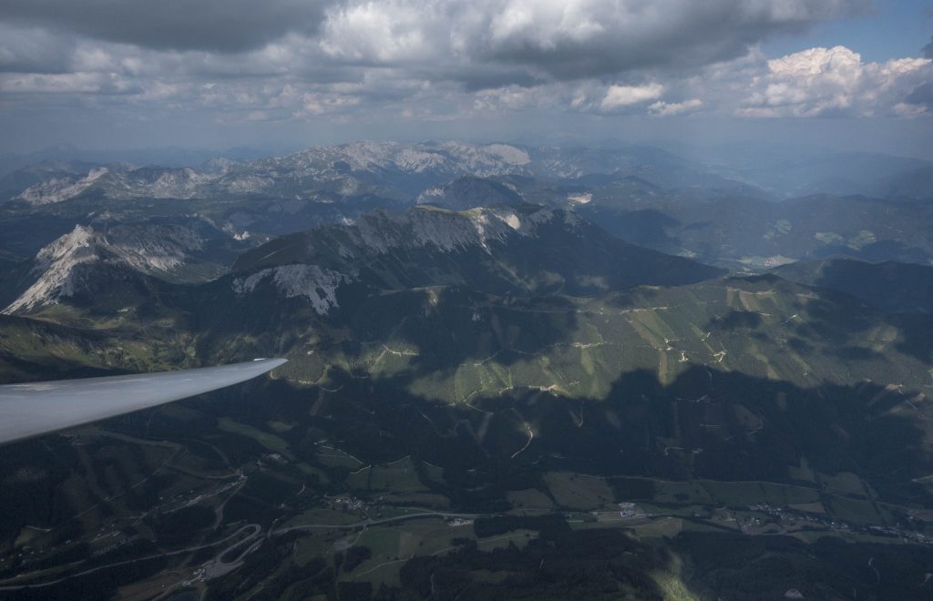
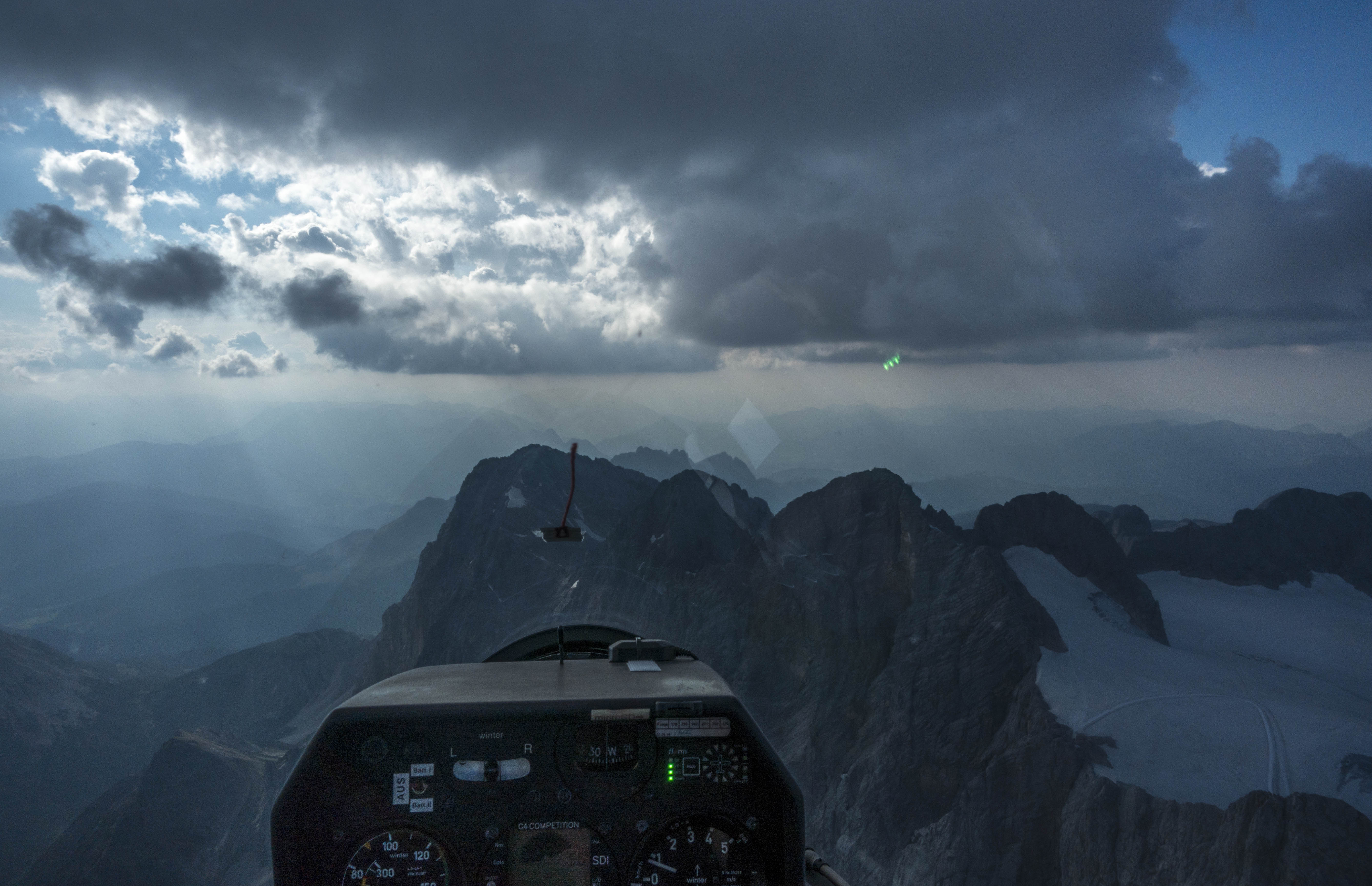
Darkening skies to the north west
I decided to turn around and found the good lift just where I had left it 20 minutes earlier. Back at cloud base I crossed the Enns Valley and found my next climb right above the summit of Grimming where I climbed to 3,100m.
The next line of clouds was 10km NNE. It was already quite dark but I still found lift under the street as I headed east past the town of Liezen. Rain began to fall and I continued further east where I found a weak climb above Dürrenschöberl. Another dark cloud promised strong lift 12km further east above Admonter Reichenstein.
5 m/s (10kt) lift under a dark cloud street
It took me less than 5 minutes to get there and I could observe the cloud getting visibly darker as I approached. Just when I thought that I was connecting with lift, the cloud’s development peaked and rain mixed with hail started to fall. I turned the ship around in no time and headed back to where I just came from.
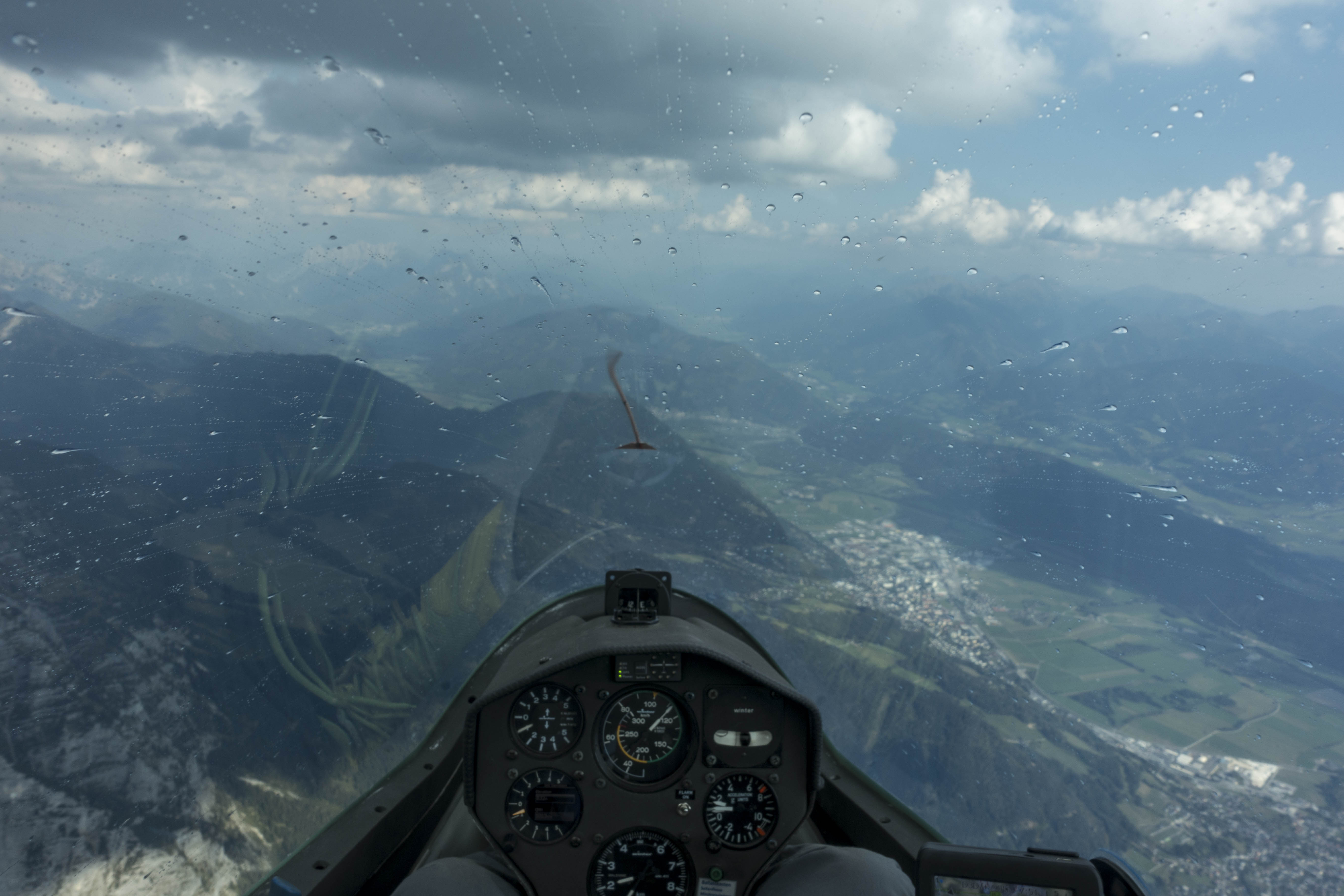
First rain is falling as I’m cruising under a cloud street.
I wasn’t sure whether Dürrenschöberl would continue to provide lift. Technically I was still within glide range of Niederöblarn but the only route to get there from my altitude would lead through the military airspace around Aigen, which meant that I would have to ask for clearance to cross it.
Just as I was about to look up the radio frequency of Aigen, I connected with strong lift again. Once again I climbed 3,000 feet within 6 minutes, gaining ample height to stay clear of the military airspace.
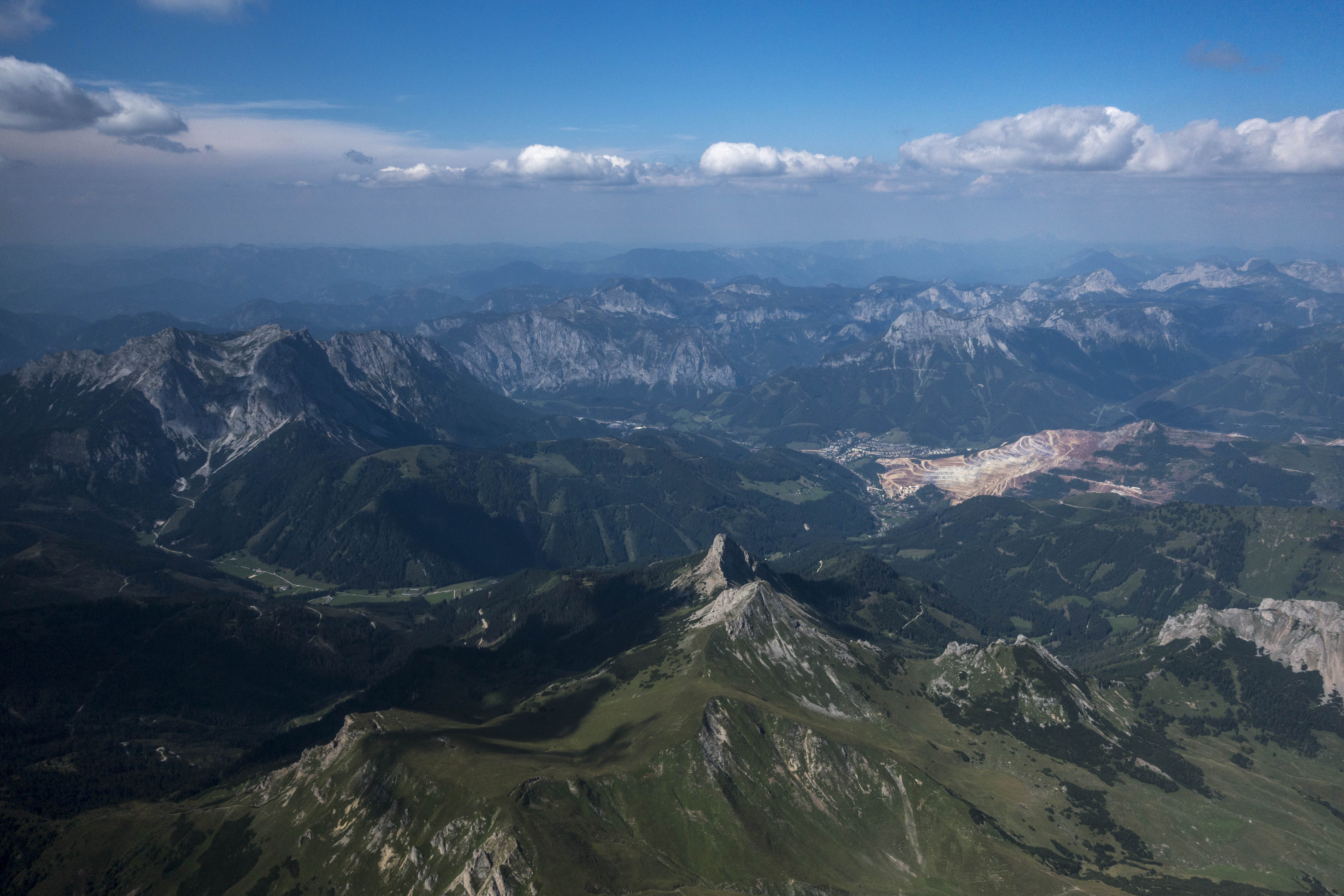
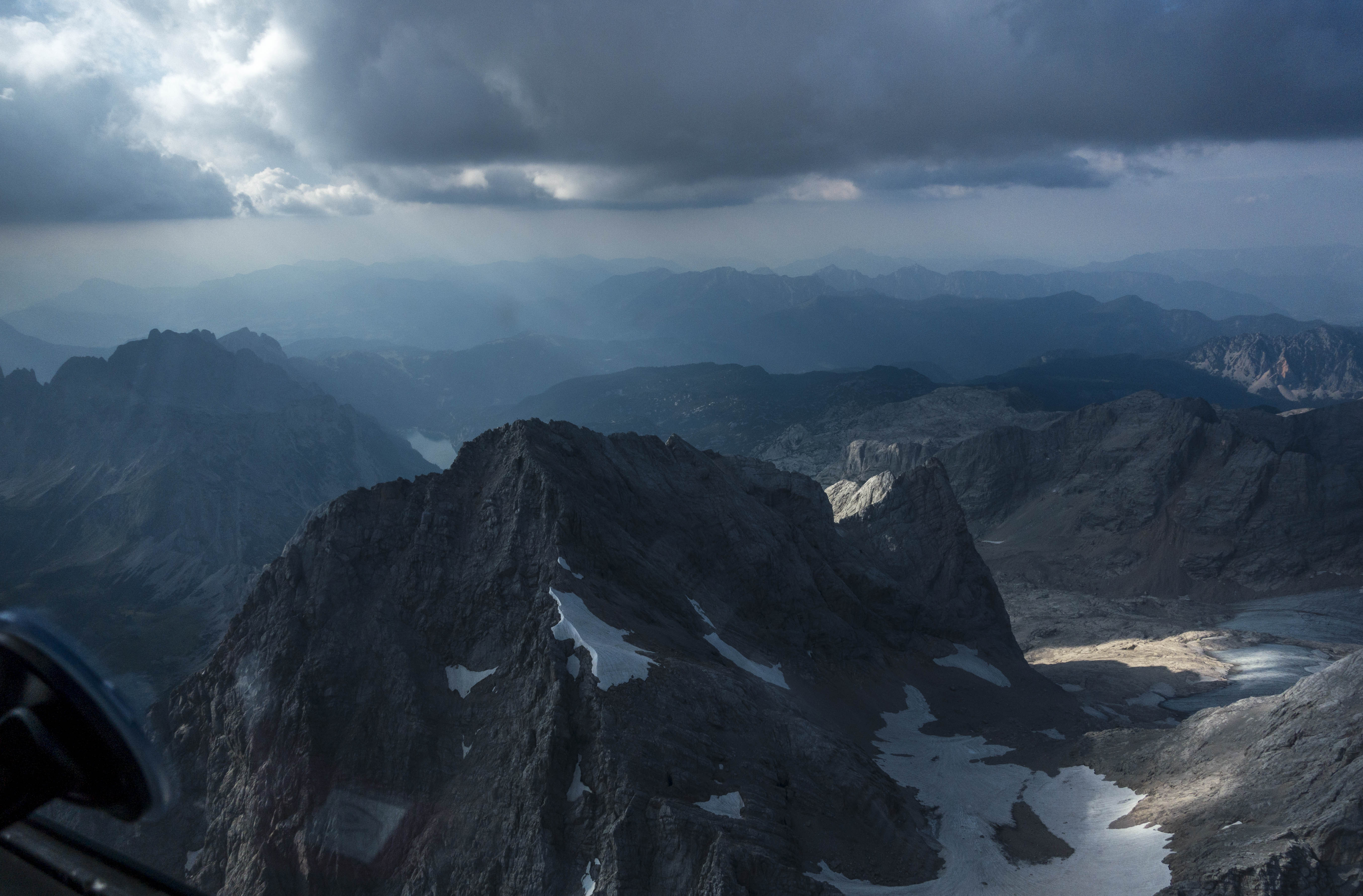
The towering cb cloud in the background (where heavy rain is falling) made me decide to land. The airport is in the valley in front of the mountain (Grimming) center-right. The storm cell was approx. 10-15 km away from the airport and slowly moving in its direction.
The skies were now rapidly overdeveloping almost everywhere. I headed back towards my initial release point above Karlspitz where I could see a monster of a cumulonimbus cloud towering to my right, north of the airfield behind the Grimming. Rain was also falling to my left.
The only area that still looked promising was further west on the south side of the Enns Valley. I had to decide whether to continue my flight in that direction and wait for the storm to pass or to get down and land before the storm would reach the airport.
I radioed ground operations with my intention to return immediately and land within 3-5 minutes. Two minutes later I entered the traffic pattern, having lost 3,500 feet. At this point the wind had picked up and ground operations had asked all planes to return to the airfield immediately. I waited for other traffic to clear the runway and managed to spot-land the DG 1001 in turbulent north-westerly winds less than three minutes later.
Pattern practice pays off. We all practice takeoffs and landings a lot during initial training. After that we don’t do it nearly as often. We might fly 50-100 hours in a season but if our average flight is 5 hours long this may only entail 10-20 takeoffs and landings. Having practiced 25 landings in 2 days for my self-start license prepared me well for landing a completely different ship in challenging conditions.
There’s a fine line between strong lift and hail. The development of thunderclouds in the mountains can happen very quickly. One minute a cloud is still fully developing and producing very strong lift, and one minute later heavy rains and even hail can fall from it. Never count on a rapidly developing cloud to provide needed lift as you may be forced to fly away from it before getting a chance to climb.
Don’t dilly-dally when a storm is approaching the airfield. When I spotted the towering cb 15 km northwest of the airfield I had to make a quick decision: land immediately or fly west and wait for the storm to pass. I believe either decision was acceptable under the circumstances. (I opted for the immediate landing because of the possibility of additional storms.) But making and executing a decision quickly was important so I could avoid a situation where I would have been forced to land in dangerous conditions.
August 12 was my second day flying in the Alps this year. The forecast conditions were rather poor, which surprised me because a cold front had passed through the day before, finally putting an end to the oppressive heat wave that had lasted for more than three weeks. Post-frontal weather often offers good soaring in the Austrian Alps.
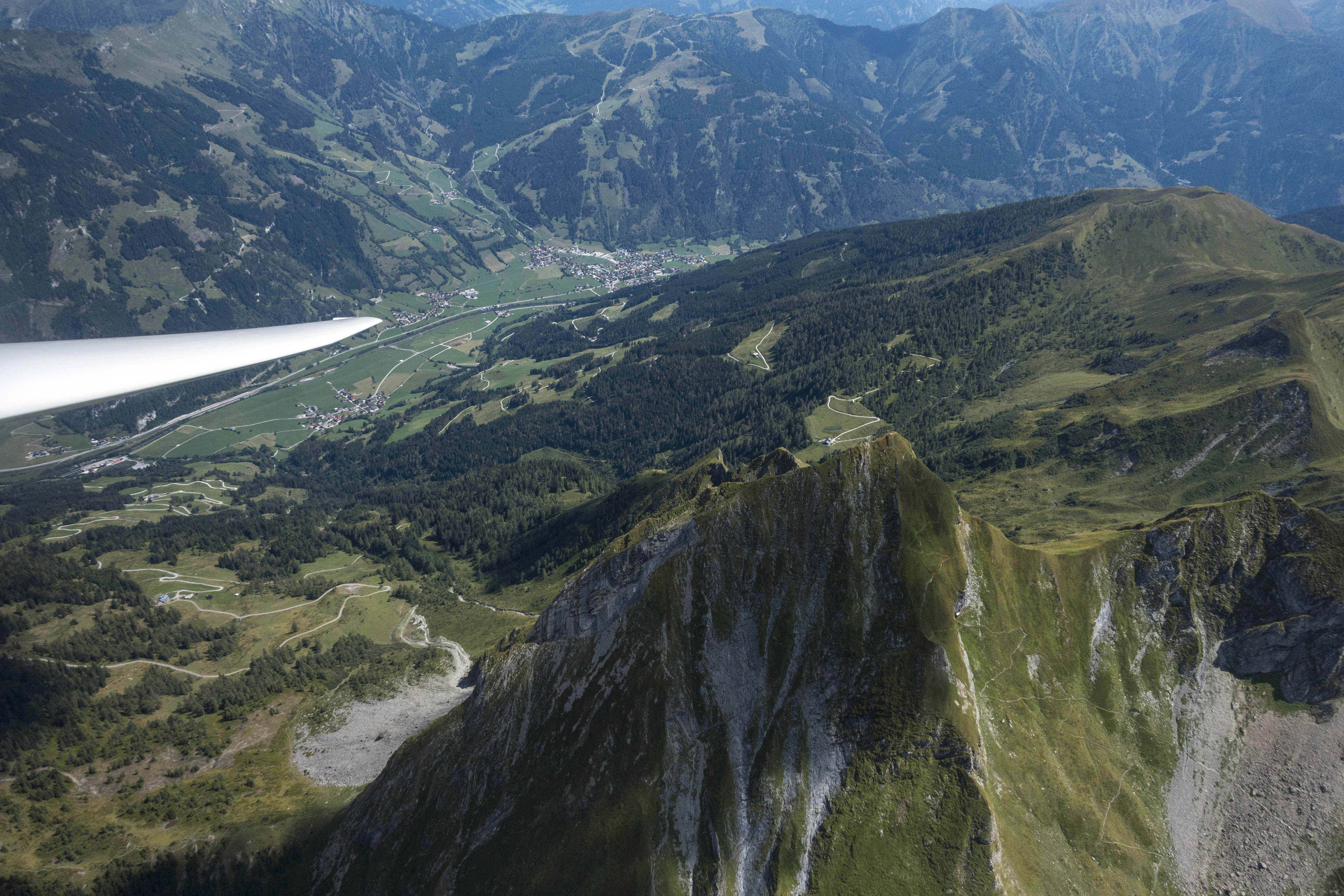
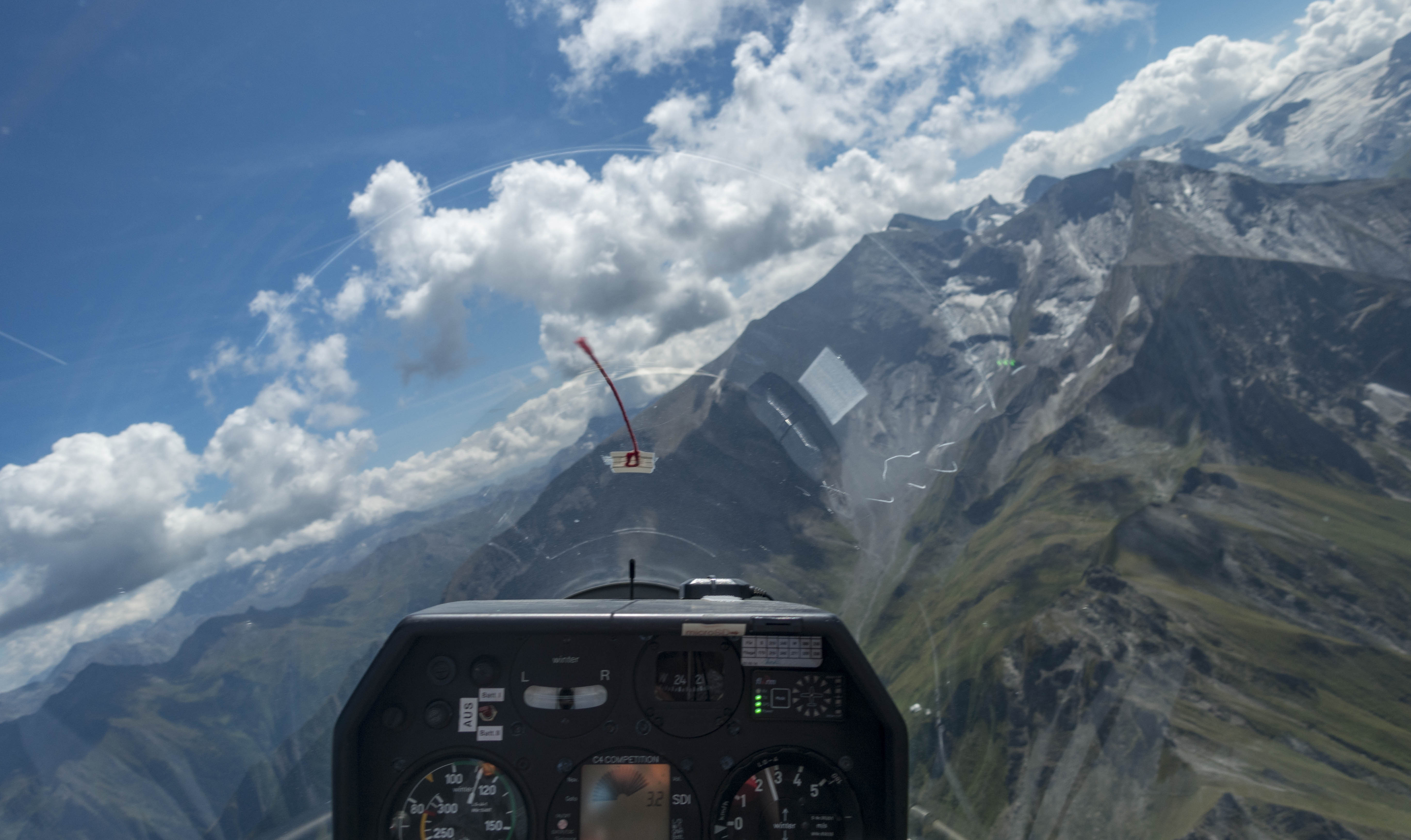
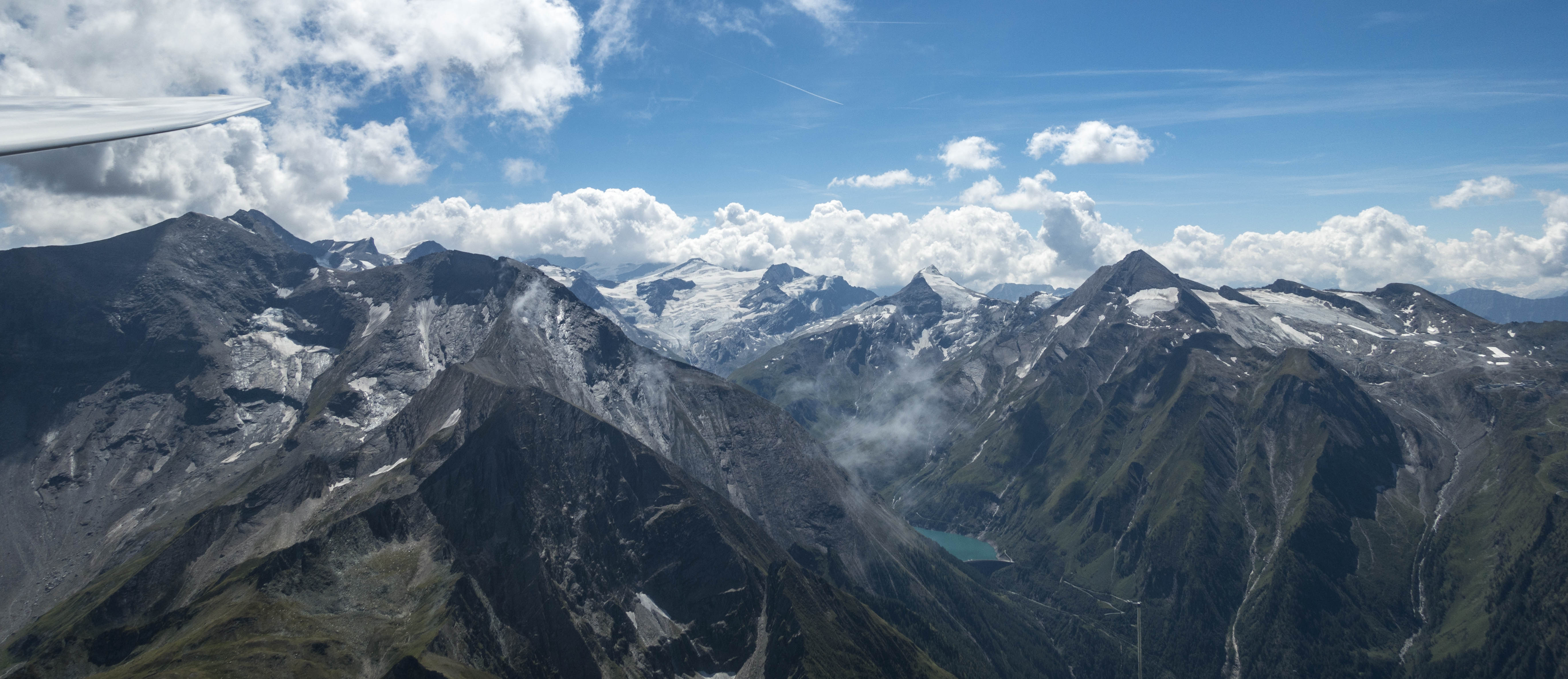
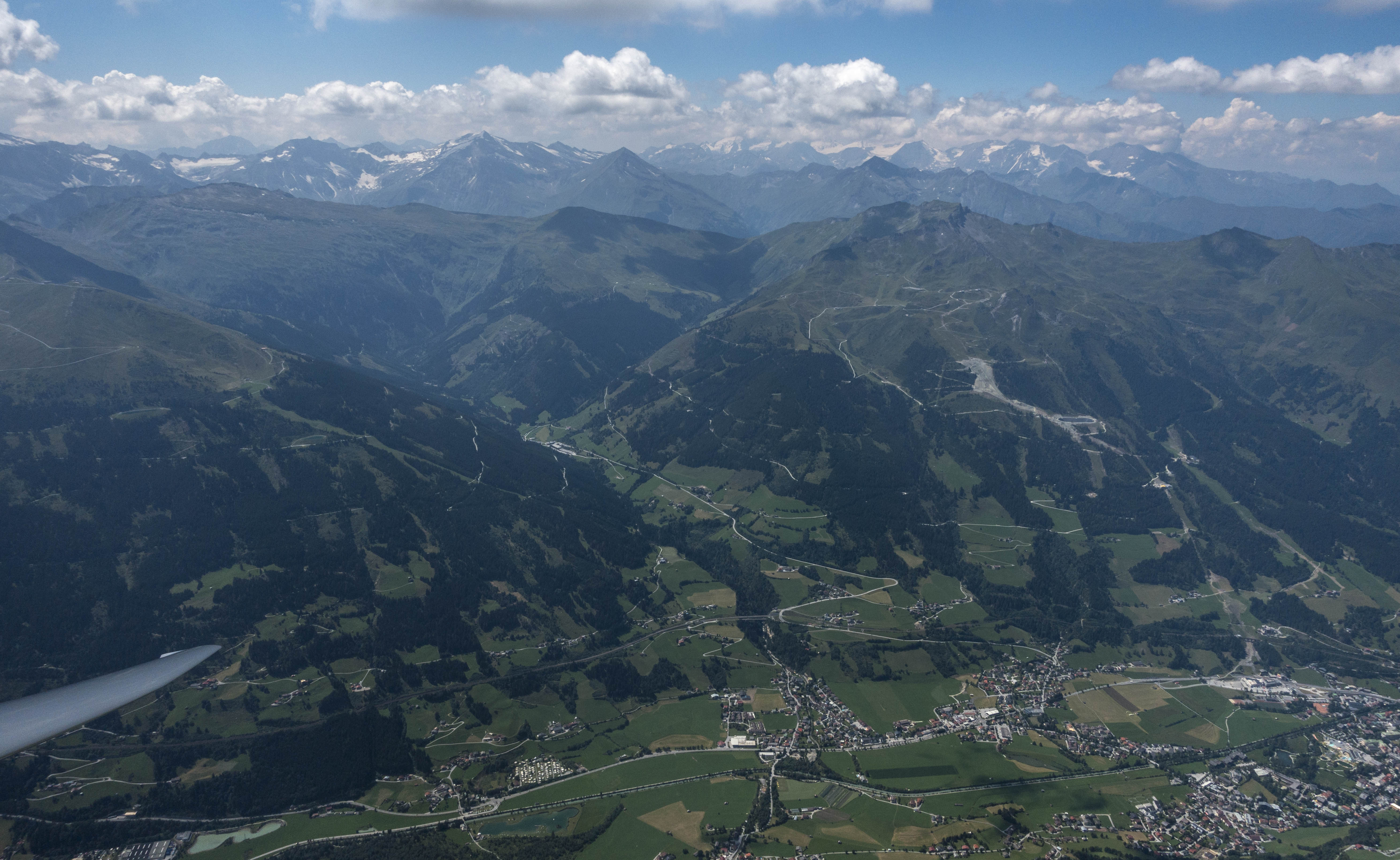
Intimidating mountains in western Austria, south of Zell am See. Note: I did not take any pictures during the first 2 hours of the flight: I was way too busy trying to make progress while looking for weak lift just a few hundred feet above the ridges. Conditions improved drastically after 2PM.
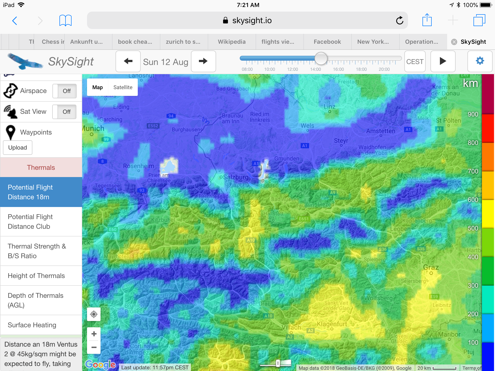
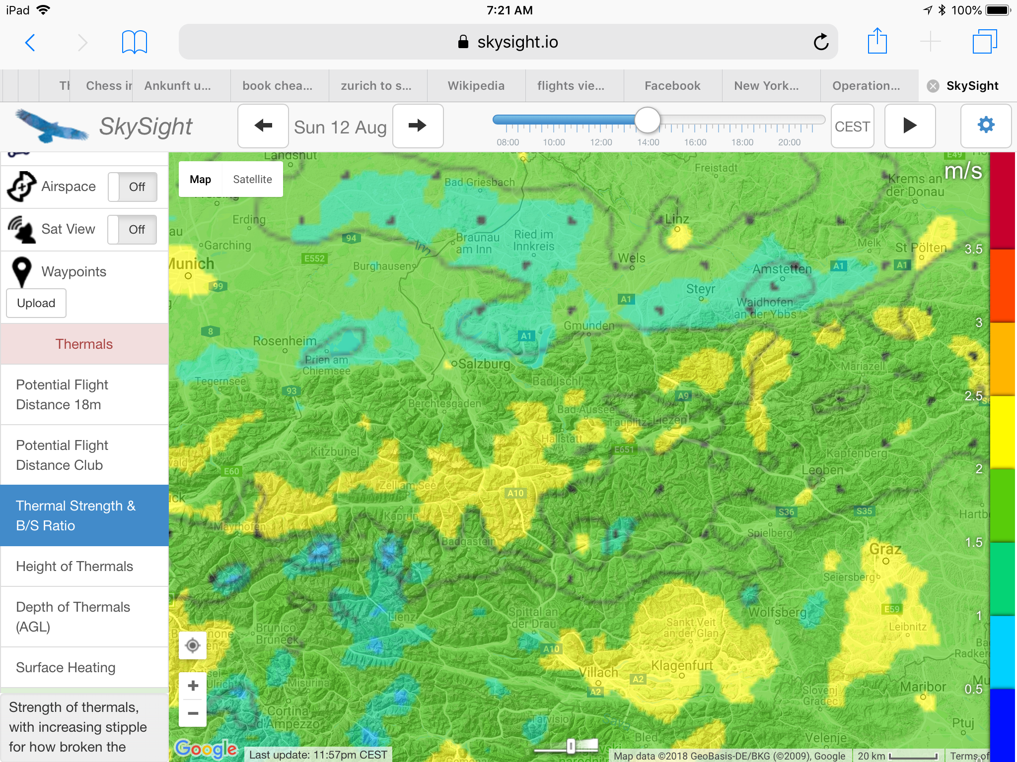
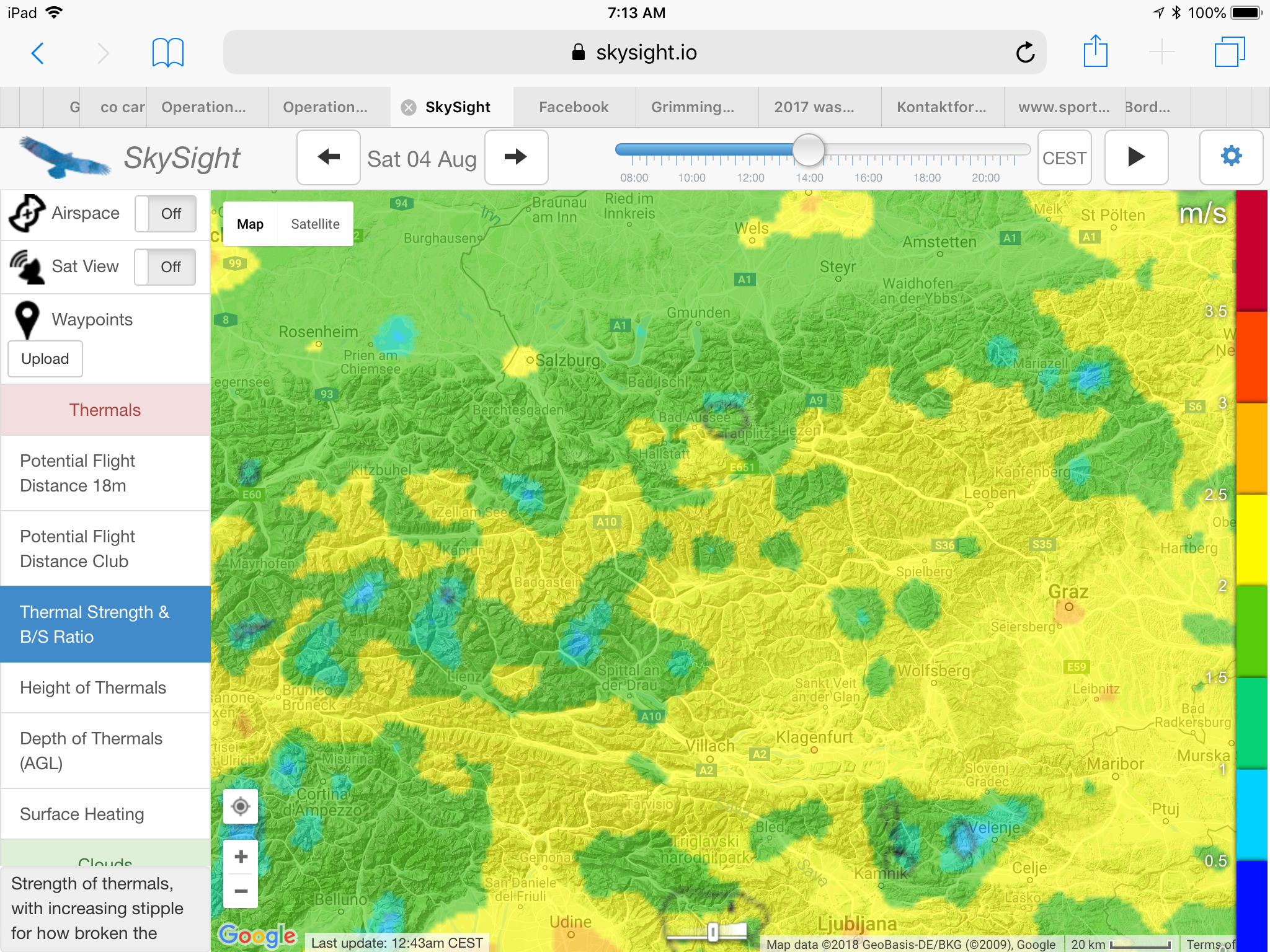
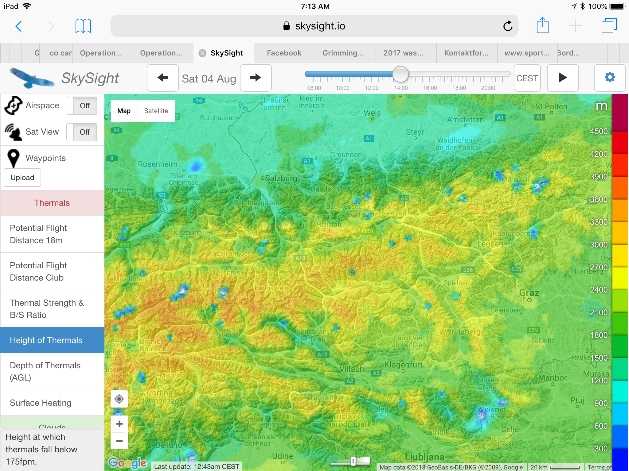
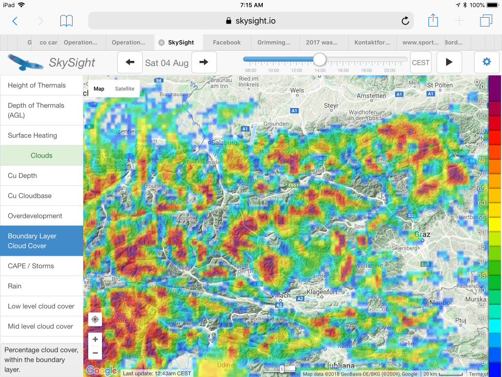
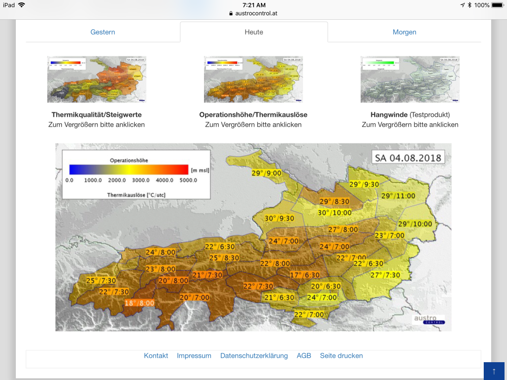
The local forecast from AlpTherm predicted weak (“schwach”) climb rates around 1 meter/second (2kts) with thermals up to 3,000m (10,000 feet). SkySight was more encouraging, indicating a potential flight distance of 400-500km (in an 18m ship) supported by a long soaring day starting as early at 10am, 1.5 – 2 m/s thermals, nice cumulus clouds, no OD, no storms, and no significant high-cloud obstruction. Light southerly winds would contribute to dense clouds stacking up on the south side of the Alps’s main spine, but were likely too weak to be usable for ridge soaring. SkySight projected even lower cloud bases than AlpTherm at the east side of my soaring area – as low as 2,400m (8,000 feet) – yet gradually rising to 3,300m (11,000 feet) further west.
Potential flight distance of 400-500km within the soaring area along the Salzach and Enns Valleys.
My drive to the airport started at the southern side of the Alps under a layer of dense clouds. As I crossed to the north at Wald am Schoberpass, the clouds gave way to deep blue skies. The air was also much clearer than in recent days: obviously the cold front had removed the inversion layer. A few low-hanging clouds clang to the slopes of the mountains, remnants of the moisture that the heavy rains of the passing cold front had left behind. There was no doubt that the sun would quickly dissolve them.
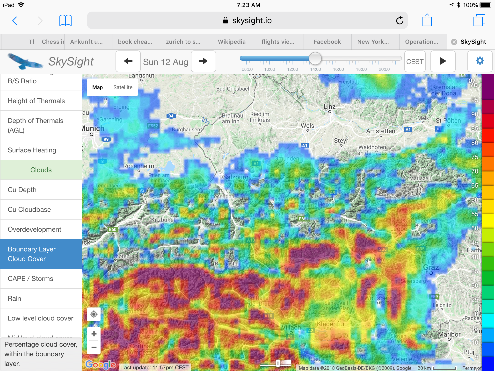
Dark red colors show dense cloud coverage forecast south of the Alp’s main spine. Nice cumulus clouds were projected to mark the lift within my soaring area.
By 10:30am the first new wisps started to form above the hills, indicating that lift was already starting to form. I moved the glider out onto the grid at Runway 04 while the air on the ground was perfectly still. I was confident that it would not take long for the valley breeze to kick in. At 11:30am the windsock finally came alive – a clear sign that it was time to launch because the thermals above the hills were sucking in air from the valley below.
Projected thermal strength of 1.5 m/s to 2 m/s (3 to 4 kts).
I was number three on the start list and airborne by 11:44AM. Once again I asked to be towed to the trusted release point near Karlspitz at 1,800m MSL (6,000 feet), around 1,100m (3,300 feet) above the valley floor, where I released in the first lift above the ridge seven minutes later.
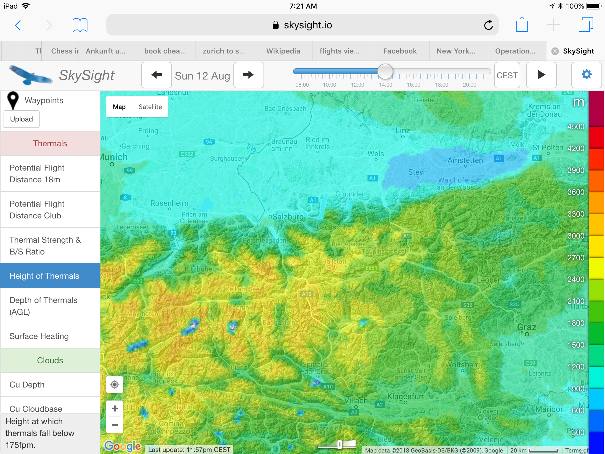
Thermal height projected at 2,400 – 3,000m (8,000 – 10,000 feet) within my soaring area – gradually improving from east to west.
Unable to climb from my release point at less than 300 feet above the ridge I thought I might have released a tad too early when a thermal above the nearby hill Zachenschöberl lifted me to cloud base at 2,400m MSL (8,000 feet). My average climb rate was 1.5m/s (3kts) – not bad considering that the day had only just started.
The local Alptherm forecast projected weak (“schwach”) climb rates of only 1 – 1.5 m/s (2-3 kts) for most of my soaring area.
I had set a tentative turn point 126km further west above Pass Thurn. To get there, I would have to first fly along a mountain chain called the “Schladminger Tauern”, followed by the “Radstädter Tauern”, and eventually the Hohe Tauern.
The first reasonably strong climb that allowed me to take out my camera came after two hours into my flight – above the peak of Bernkogel – west of the village Dorfgastein (in the valley below). Note the steep switchbacks of the hiking trail on the face of the mountain. Climbing is so much easier in a glider!
The peaks of the Schladminger Tauern and the Radstädter Tauern top out at about 2,850m (9,500 feet). The ridge lines along the foothills are typically about 1,800 to 2,400m high (6,000 – 8,000 feet). Every 5-8 km or so I would have to cross one of these ridges.
A cloud base of 2,400m did not leave a lot of wiggle room: I would have to climb to cloud base above a ridge line, glide through sink to the next ridge, hopefully arrive there with a decent safety margin, find a climb that would take me back to cloud base, fly through sink to the next ridge, and so forth. To make progress, pretty much every ridge line had to offer a climb and I would have to be able to locate it quickly once I got there. Should a ridge not work upon arrival, I would have to follow it towards the main valley (perpendicular to my intended route) and look for climbs along the way. Should I find myself unable to work my way back up, I would eventually have to land at one of the few land-out fields in the main valley.
The cloud bases lifted to 3,300m (11,000 feet) by mid-afternoon – still well below some of the highest peaks of the Austrian Alps.
Eventually I would get to the “Hohe Tauern”, which were much taller with peaks around 3,600m (12,000 feet). Low hanging clouds, tall mountains, and soaring don’t mix very well; therefore, I planned to cross the Salzach Valley around Zell am See to the north side and then continue along the lower Kitzbühler Alpen, which top out around 2,500m (8,300 feet) until I would get to my turn point. From there I would retrace my route back towards the east, continuing on to a second turn point at Admonterhütte near the town of Admont and then return back to Karlspitz for a total task distance of 325km. That was the plan.
As I headed out on task I observed a seemingly endless line of clouds along the south side of the Alps, just as Skysight had predicted. On the north side, where I was flying, small but pretty cumuli started to form right above almost every ridge line.
Circling in nice lift late afternoon when conditions were great and soaring was easy. You can see the dense line of clouds in the background on the far (i.e. southern) side of the mountain range. These clouds prohibited a crossing of the Alps to the south and did not dissolve until late in the day.
My first ridge to cross would be near the peak of Gumpeneck, 2,226m tall. I had hoped to arrive just at the level of the peak, high enough to connect with the thermal breaking off the mountain. However, when I got there I was down at 2,080 meters, just a little too low to get into lift. That meant plan B: follow the ridge out towards the Enns Valley. Only one kilometer later I found weak lift above the ridge, worked my way up to to 2,300m, flew back to the Gumpeneck, and climbed back to cloud base at 2,370m. On to the next ridge!
I arrived 130m AGL (400 feet) above the next ridge and quickly found the next climb, which took me from 2,200 to 2,570m. Great! The cloud bases were getting higher. Onwards!
The next ridge was 2,200m high. I arrived there 300 feet above ground, following along the ridge for about 2 kilometers but did not find a climb. Time for plan B again: change direction, and fly above the next lower ridge line out towards the Enns Valley. 50 meters AGL I found the next climb, taking me from 2,150m back to cloud base at 2,480m. Time to push west again!
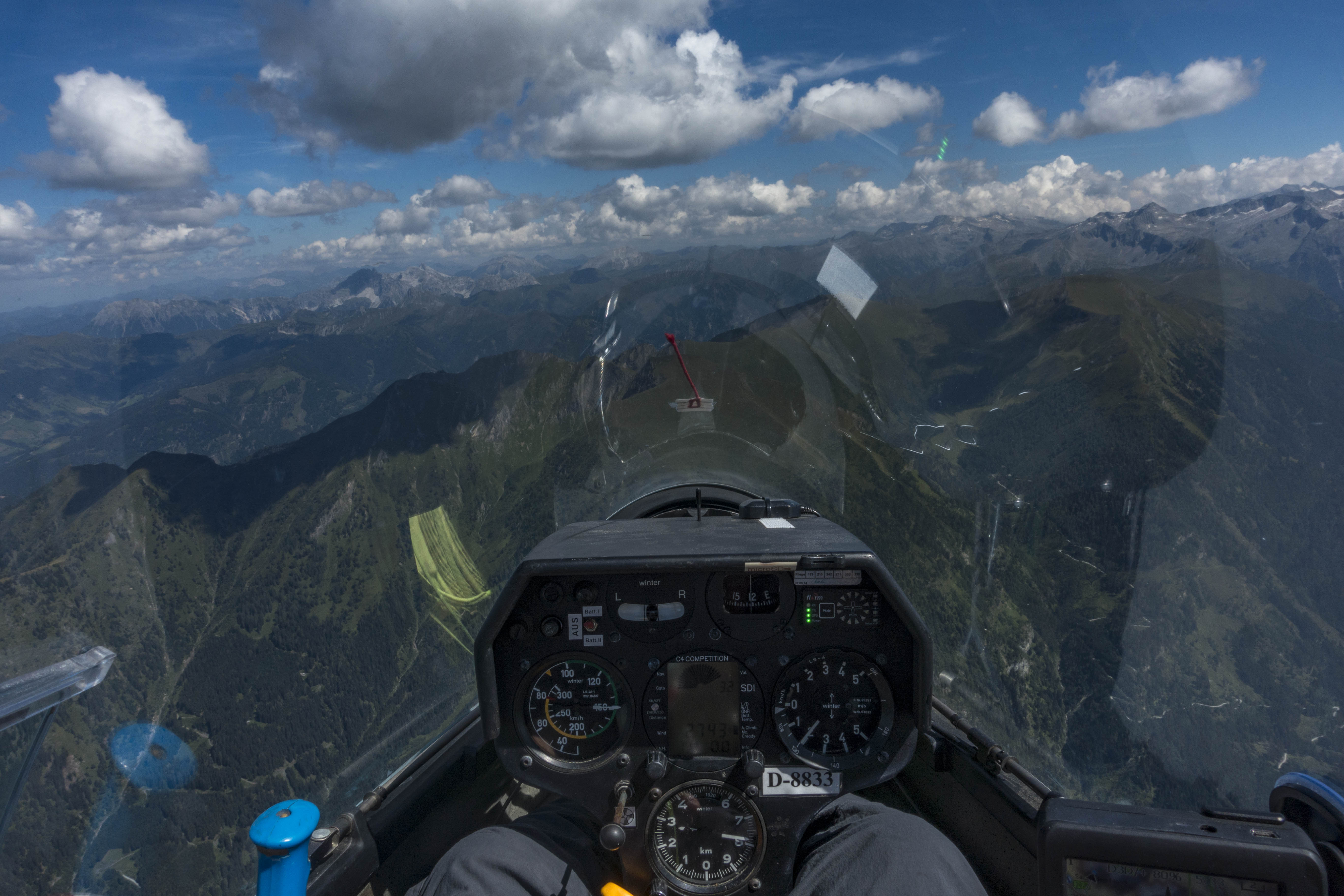
Cockpit view of the LS4. Cruising at 150 kph only became an option by mid-afternoon when the cloud bases were well above the ridges. Earlier in the day I was scratching along from one ridge to the next at 110-120 kph.
The next two ridges were good enough to maintain altitude but provided no climb. I was only 1 kilometer north of a peak that was 2,450m tall – too high. The lift was probably above the peak but I was down at 2,350m and couldn’t get there. So I continued on.
The next ridge was slightly lower at 2,150m. I got there 100m AGL and found a nice climb back to cloud base at 2,580m.
This is how my flight towards Zell am See continued. I found climbs to cloud base above each of the next three ridges, then skipped a ridge and had no choice but to take the next climb back to 2,500m even though the climb rate was dismal. A fun way of soaring but mentally very demanding. And so slow!
The mountain chain in the center is Hochkönig. On the back side is the city of Berchtesgaden in Germany.
Then came the next ridge and finally some reprieve: my first 2 m/s (4kt) climb of the day took me to a new high: I was at almost 2,900m! The airport of Zell am See was now within easy glide range and I could relax a bit. But I was already 90 minutes on task and had only covered just a bit over 50km!
I continued to push on and the flying finally got faster and easier. Climb rates continued to improve and the cloud bases increased further. The additional altitude gave me room to increase my inter-thermal cruise speed from 120 kph to 140 kph. Above Bernkogel I averaged 2.5 m/s and climbed to 3,050m. Oh what luxury!
Finally I had time to look ahead towards TP1. At least in theory there were two ways to get there: 1) continue on the south side of the Salzach Valley and cross to the north side near TP1; or, 2) cross to the north side near Zell am See (as I had initially planned) and then continue along the Kitzbuühler Alpen.
The southern route looked very challenging: the mountains to my left were intimidating: the peaks towered high above my glider and were well above cloud base. The ridge lines ahead were short and provided few options to find good climbs. There was still some wind from the south and I dreaded the prospect of flying in the lee of these monsters. Unfortunately, the northern route did not look very promising either. The sky in that direction was mostly blue and the cloud bases were much lower. Crossing over to the north looked straightforward but would I be successful in crossing back south? I didn’t know.
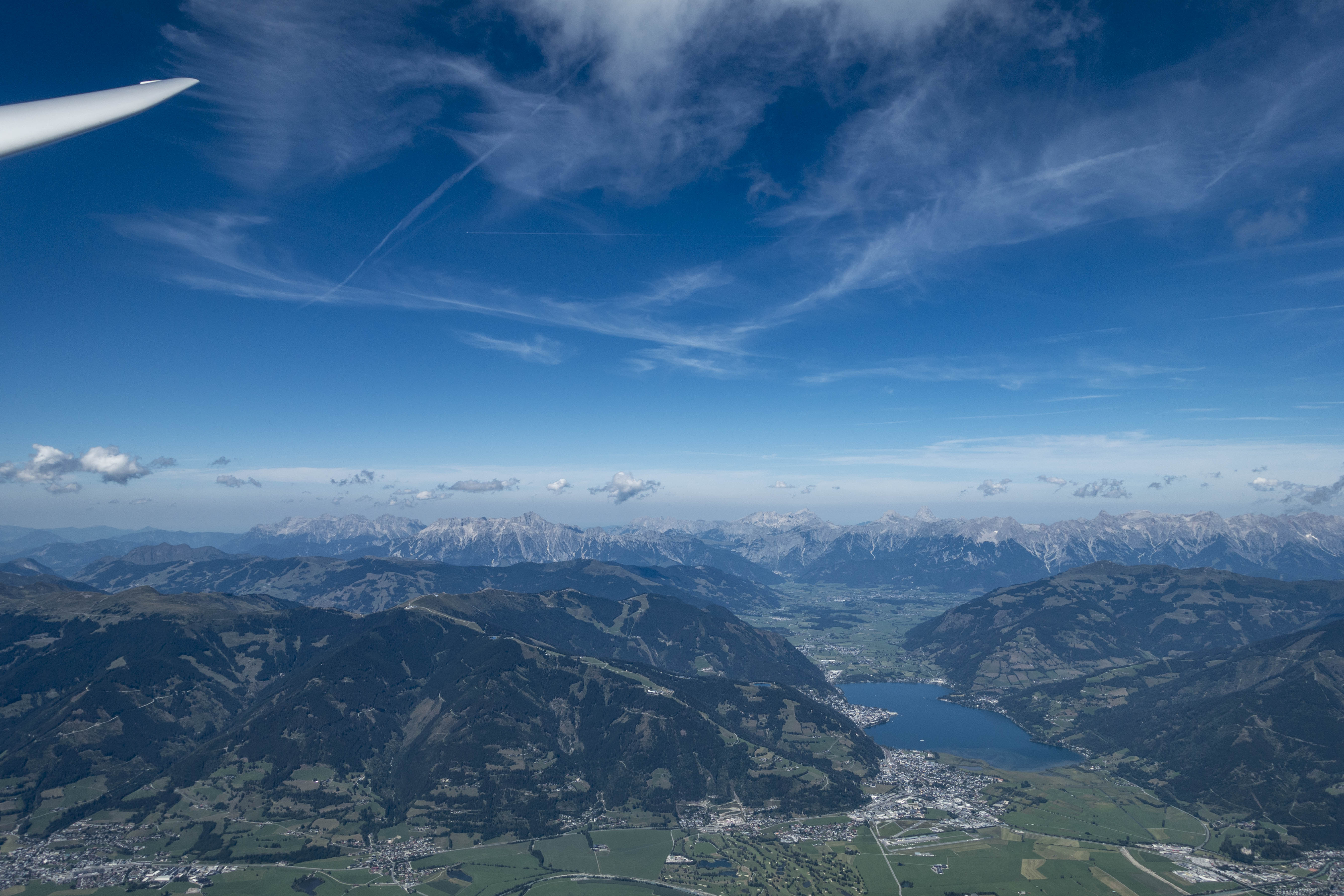
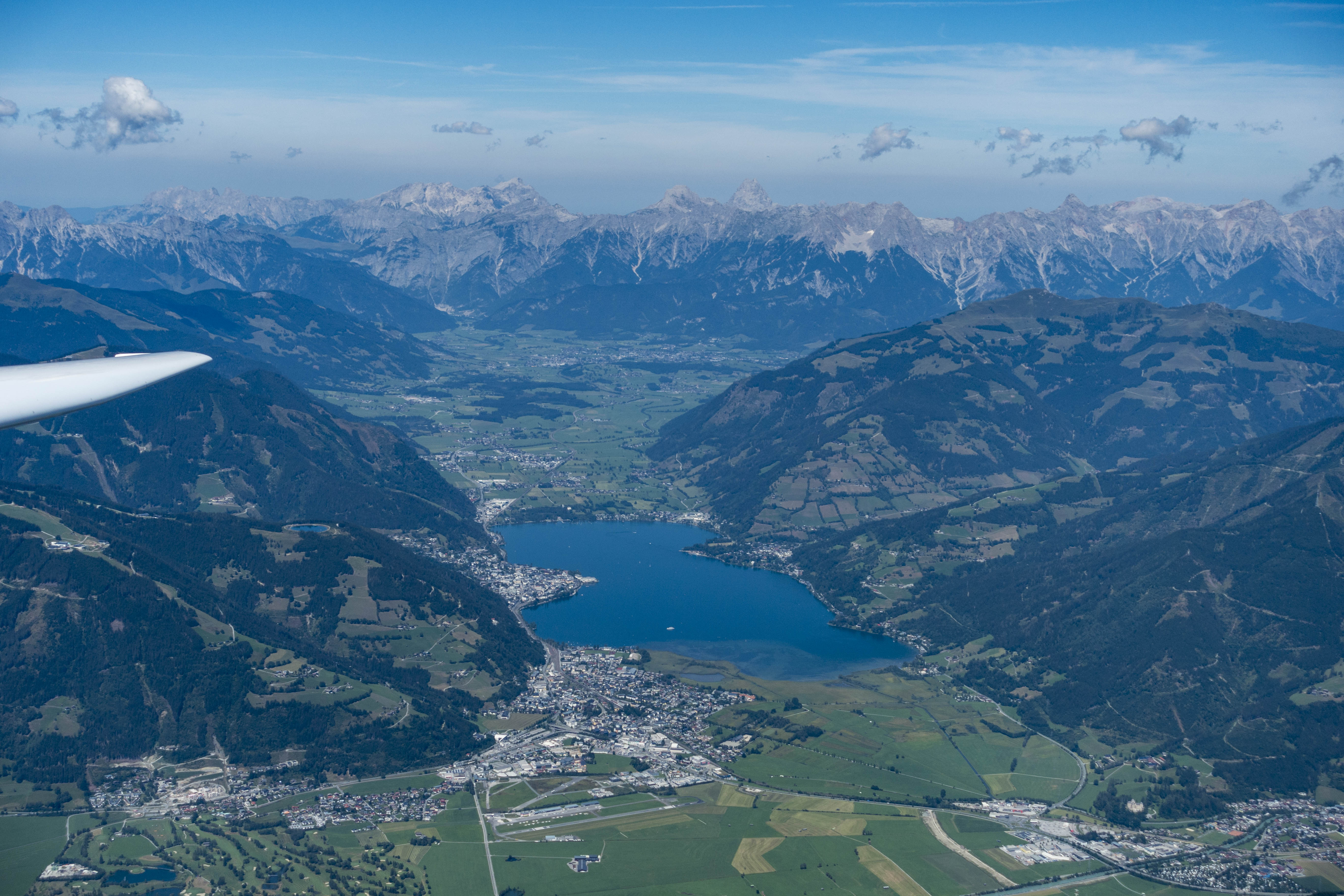
The town of Zell am See is below in front of the lake (Zeller See). You can spot the runway of the local airport in the foreground on the right – like Niederöblarn one of the most popular and most scenic glider ports in the Austrian Alps. The hills on the left side are part of the Kitzbühler Alpen – the cumuli on that side were few and far between and the cloud bases lower.
For a while I contemplated my options. The airport of Zell am See – one of the premier soaring sites in Austria – was right below and provided an easy and safe landing option in case my adventure to the north side did not work out. However, I could not see any other gliders around, which caused some doubt in my mind regarding the conditions on the south side. Also, it had already taken me more than two hours to get here and I didn’t know how long it would take to get back. It was 2:15PM and Skysight had predicted thermal activity to weaken considerably as early as 4PM. Ultimately, the doubtful voices prevailed. I decided to abandon my task and turn around.
In hindsight, my concerns were probably overblown. Conditions continued to improve. I averaged almost 3 m/s on my next climb and reached 3,150m. Finally I was able to skip some ridges if the attainable climb rates did not reach my expectations. My average speed, which had only been 56 kph on my outbound leg, improved to 78 kph on my next leg.
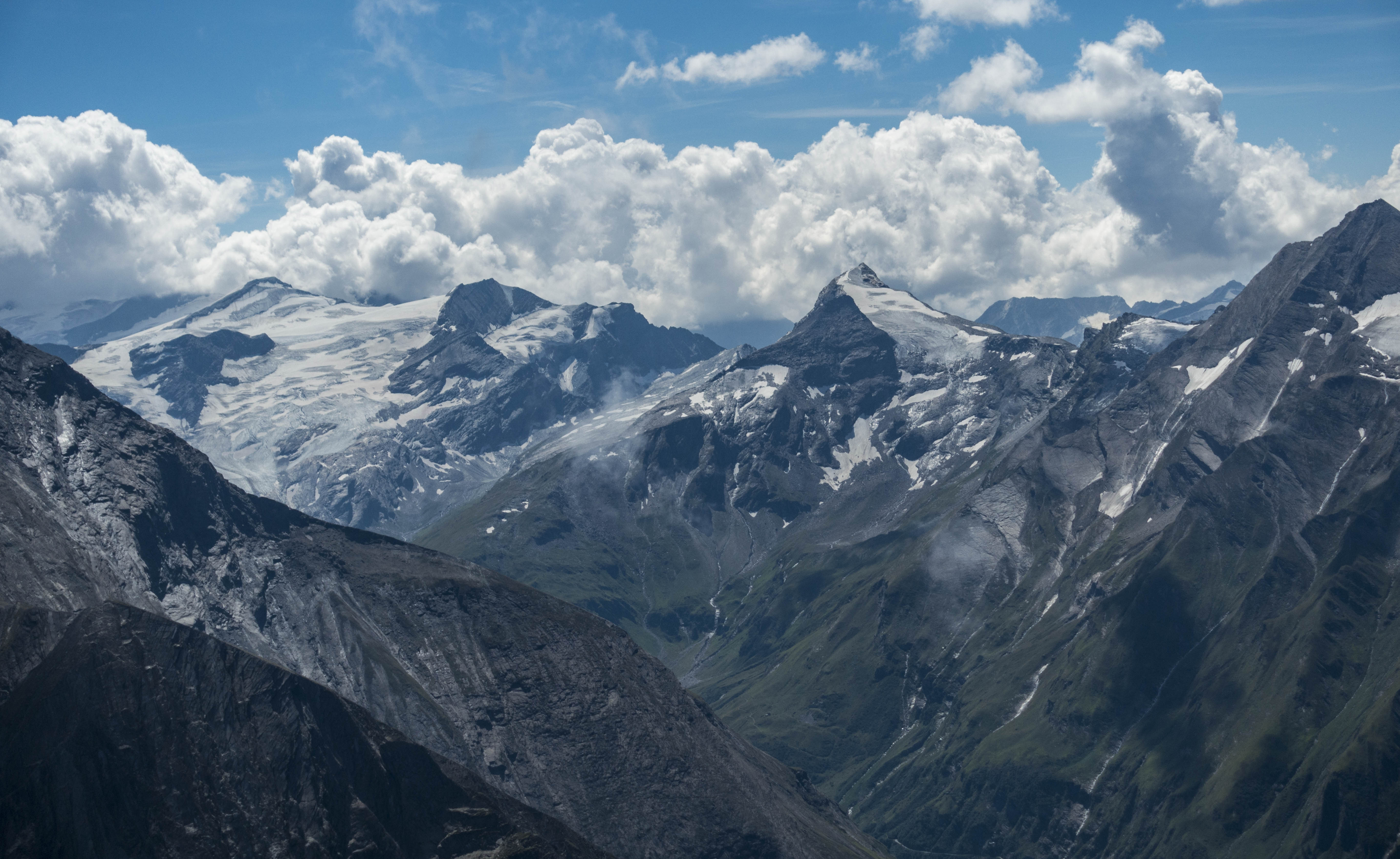
Another amazing look into the steep and narrow valleys of the Hohe Tauern (High Tauern) – Austria’s tallest mountain range.
Once I was back within final glide range to my start airport in Niederöblarn I reversed course again to head back west to see if I could further improve my average speed. Indeed: on my second westbound leg that took me back to Zell am See again I averaged 82 kph.
I briefly thought about continuing to TP1 now as the Kitzbühler Alpen looked considerably improved, but it was almost 4PM and prudent caution won again.
And another look at Zell am See at the foot of the high peaks on the opposite side of the Salzach Valley.
I had not anticipated that things would get better still until thermal strength peaked around 4:30PM. On my second eastbound leg I averaged 105kph. I started to wonder if I could even score for the OLC Speed League despite the excruciatingly slow start.
Around 5PM, however, it quickly became obvious that the day was coming to an end. I crossed the Enns Valley, found another climb over the Grimming and added a sightseeing flight along the Northern Limestone Range. I had hoped for a similar late-day “radiation-lift” effect from the steep south-facing cliffs as I had noticed on my prior flight on August 4. However, this time the air along the shaded cliffs just produced sink.
View of the Dachstein Massif from above Planai Peak (directly below). The world cup downhill ski racers start at the top of the mountain that can be seen in the bottom left corner of the picture. This downhill track was long the fastest in the world.
Near Dachstein I crossed the valley again and found the day’s last thermal over Planai Peak, famous for world-cup ski racing. From there I followed the ridge lines, which had become completely still, back to the airport in Niederöblarn for one of my smoothest touch-downs ever in completely calm conditions just before 6PM.
View towards the west as the clouds started to dissolve in late afternoon.
Total flight distance 392km. Average Speed, unsurprisingly slow, at 68.5 kph. The flight track is here.
Lessons Learned
Flying low is (mentally) demanding. The work load is dramatically higher when you have no choice but to fly low. Having a plan A (where to go for lift), a plan B (where to go if lift does not materialize), and a plan C (where to escape to – if necessary to land – if plan B does not work) is critical. And what your plan A, B, and C ought to be changes constantly. I.e., every few minutes you may need to formulate a new plan A, B, and C. That’s a lot of work.
Lift above the ridges can be very narrow. I noticed that the lift close to the ridges can sometimes be just a thin band that may be impossible to circle in. If it is wide enough to circle a steep bank angle (40-45 degrees) is often required to stay in lift – also and especially because you can’t afford to get close to minimum speed while in close proximity to the terrain. Two or three times I found myself circling with other gliders who ended up dropping out of the lift because their circles were just to wide.
Always arrive above the ridges. Hopping from ridge to ridge only works if you can be sure of arriving above the next ridge line, ideally above the highest peak along the ridge for that’s where you will most likely find the next climb. If you’re not 100% certain of that, than your plan B must include a path over another (lower) ridge line that you can reach for sure above the ridge (plan B) and from where you can escape to a landable area (plan C).
Always watch your airspeed as you approach a ridge. When you are approaching a ridge close to terrain you might intuitively pull back on the stick and inadvertently reduce your airspeed. Never let that happen. Flying close to terrain is dangerous and flying too slow and too close to terrain can be a fatal combination. I kept reminding myself of this throughout the flight.
The combination of low cloud bases and weak lift makes you SLOW. The obvious part of this is due to the fact that you take a long time to circle in weak lift and that you have to maintain a modest airspeed even in cruise mode. Less obvious are the other delays: i) you have to take (almost) every climb simply because it is still better than plan B. ii) And if plan A does not work you may be forced to significantly detour from your intended flight route simply to find the next climb and stay aloft – as a result you end up flying many more unintended miles along the way and this is what really slows you down.
Skysight has been remarkably accurate. Always read any forecast with some skepticism and never expect it to be 100% correct in every respect. However, once again Skysight was very close to reality: e.g., by mid-afternoon, climb rates were a little stronger than forecast and cloud bases a little bit higher. The most clouds were almost exactly where Skysight had predicted them to be. The start and end of the soaring day were both perhaps 30-45 minutes later than forecast. The southern side of the Enns Valley worked a bit better than forecast and the north side a little worse. But overall, Skysight was remarkably on target. Having worked with it now in different geographies and widely different conditions I believe it’s the best soaring forecast out there at the moment.
Europe is enduring a pro-longed heat wave with near record high temperatures from Portugal to Austria. That means the nicest place to be is right at cloud-base where the temps are much more comfortable.
At cloud base above the Central Alps in the middle of Austria. The Tappenkarsee is below. The peak to the left is called Faulkogel, 2,654m (8,700 feet) MSL. Where else would you rather be?
This past Saturday promised nice soaring conditions in Central Austria:
Moderate thermal strength of 2 m/s (4 kts)…… cloud bases around 3,000 meters (10,000 feet) …… high probability of cumulus clouds marking the lift …… only modest risk of overdevelopment …… a moderate risk of thunderstorms mainly confined to the area north of the northern limestone range …… hardly any wind within the boundary layer …… convergence lift of 1-2 kts along the spine of the mountains (as a result of the valley breeze that lifts air along the slopes of the mountains, converging and rising off the tops of the ridge lines) …… no high clouds shielding the sun …… culminating in a projected attainable flight distance of 500-600 km in an 18 meter glider. (I was flying a club class ship with a projected attainable flight distance of approx. 400-500km).
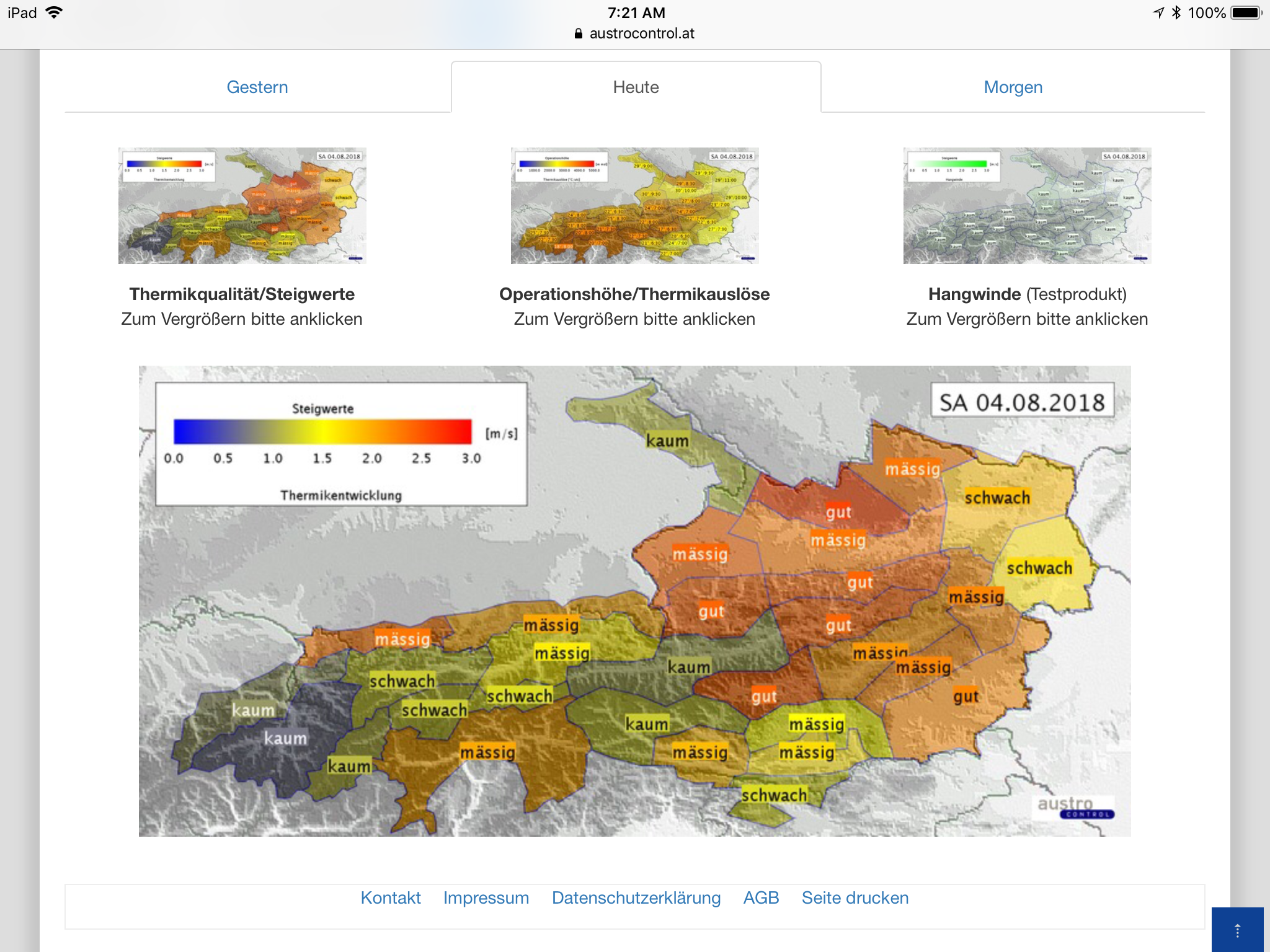
Skysight’s predictions were also confirmed by the local soaring forecast from Austrocontrol, which projected:
“Good” thermal conditions in line with Skysight’s prediction of a thermal strength of 2 m/s (4 kts), …… a trigger temperature of 24 degrees C, expected to be reached as early as 7 am (!), and a maximum thermal height of approx. 3,300m (11,000 feet) MSL.
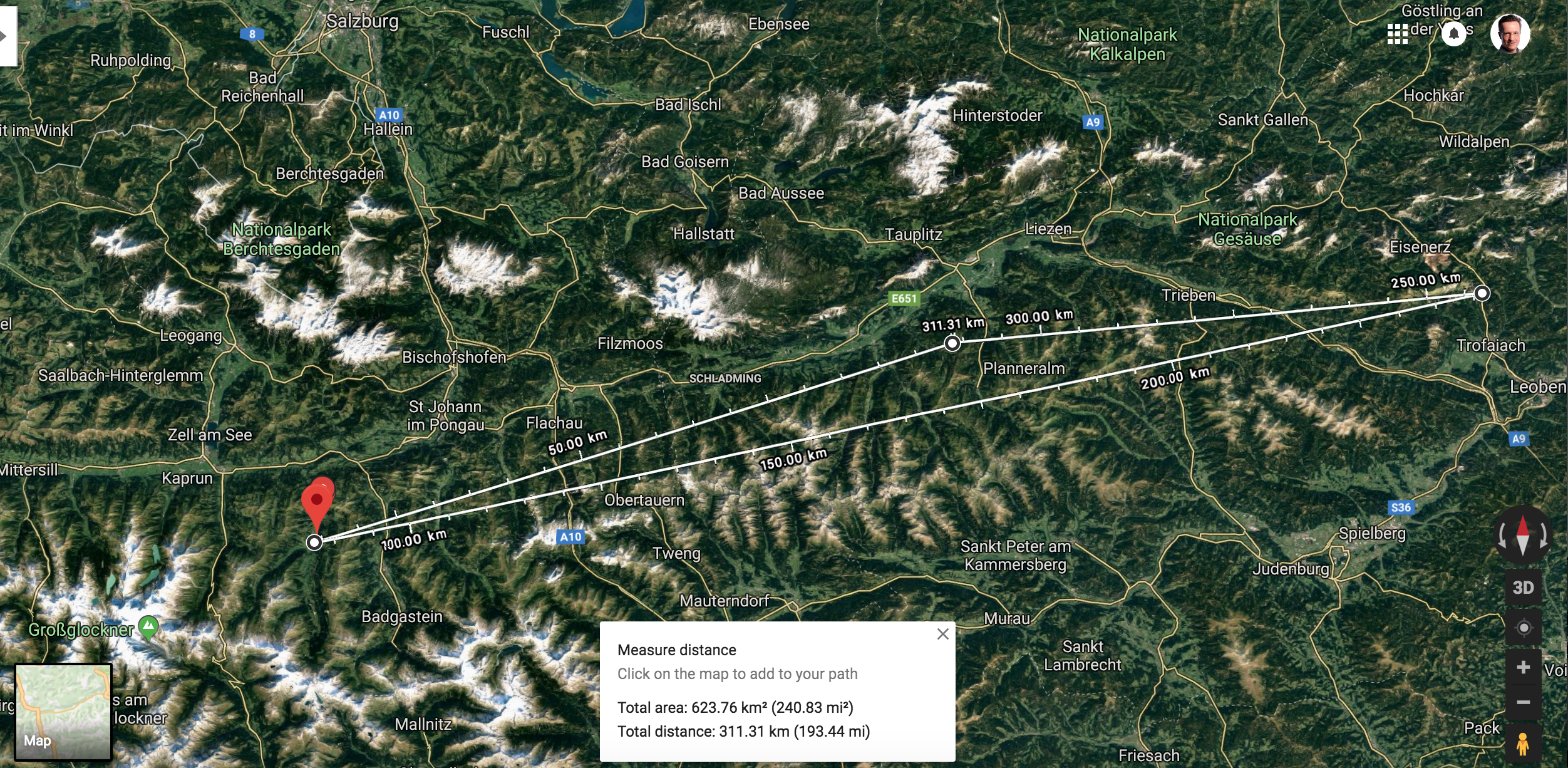
Considering the consistency of both forecasts, I thought it appropriate to plan my first pre-declared 300km triangle in the Alps:
Start above Karlspitz, approx. 7 km south of my launch point at LOGO (Niederöblarn airport). This is the location of one of the “house-thermals” and a frequent release point for gliders flying from LOGO. From there I would head 85 km westward towards …
… TP1 near the village of Wörth in the province of Salzburg at the foot of Austria’s tallest mountain, the Grossglockner. The peak of Grossglockner (3,798 m or 12,461 ft) was well above the projected thermal height and likely unattainable. A second eastbound leg of 156 km would take me to …
… TP2 above the village of Vordernberg, in the province of Styria near the town of Leoben. And from there it would be 69 km to the …
… finish line, once again above Karlspitz. Total task distance: 311 km.
Task as shown on Google maps.
I had reserved the LS4b of the fleet of Niederöblarn. It’s a very comfortable club class ship with a performance slightly worse than that of the Discus that I’m usually flying from Boulder. Since I had not flown in Austria in more than 12 months I had to take two brief check-rides in the DG 1000 with a local instructor. This was a nice opportunity to refresh my spin training (a lot of fun!) but it meant that I wouldn’t be able to launch on my own before noon. Given my relatively late start, the 300km task distance seemed appropriate.
I released near Karlspitz a few minutes past noon and rounded the start sector above the peak four minutes later at an altitude of 2,200m MSL. I followed the ridge line to the SSW to further gain altitude. One of the great phenomena of flying in the Alps is the amazing predictability of thermal lift directly above the ridge lines, especially in low-wind conditions and in the middle of the day when the sun heats both slopes equally: warm air rises up along either side of the ridge and when it reaches the top of the ridge line, both streams converge and the air has no place to go but up.
The lift is not necessarily consistent, but it often averages 1-3 kts, which is usually sufficient to maintain or even slightly gain altitude as long as one flies directly above the top of a ridge. Thermals will then break off the ridge line as well, usually above distinctive peaks.
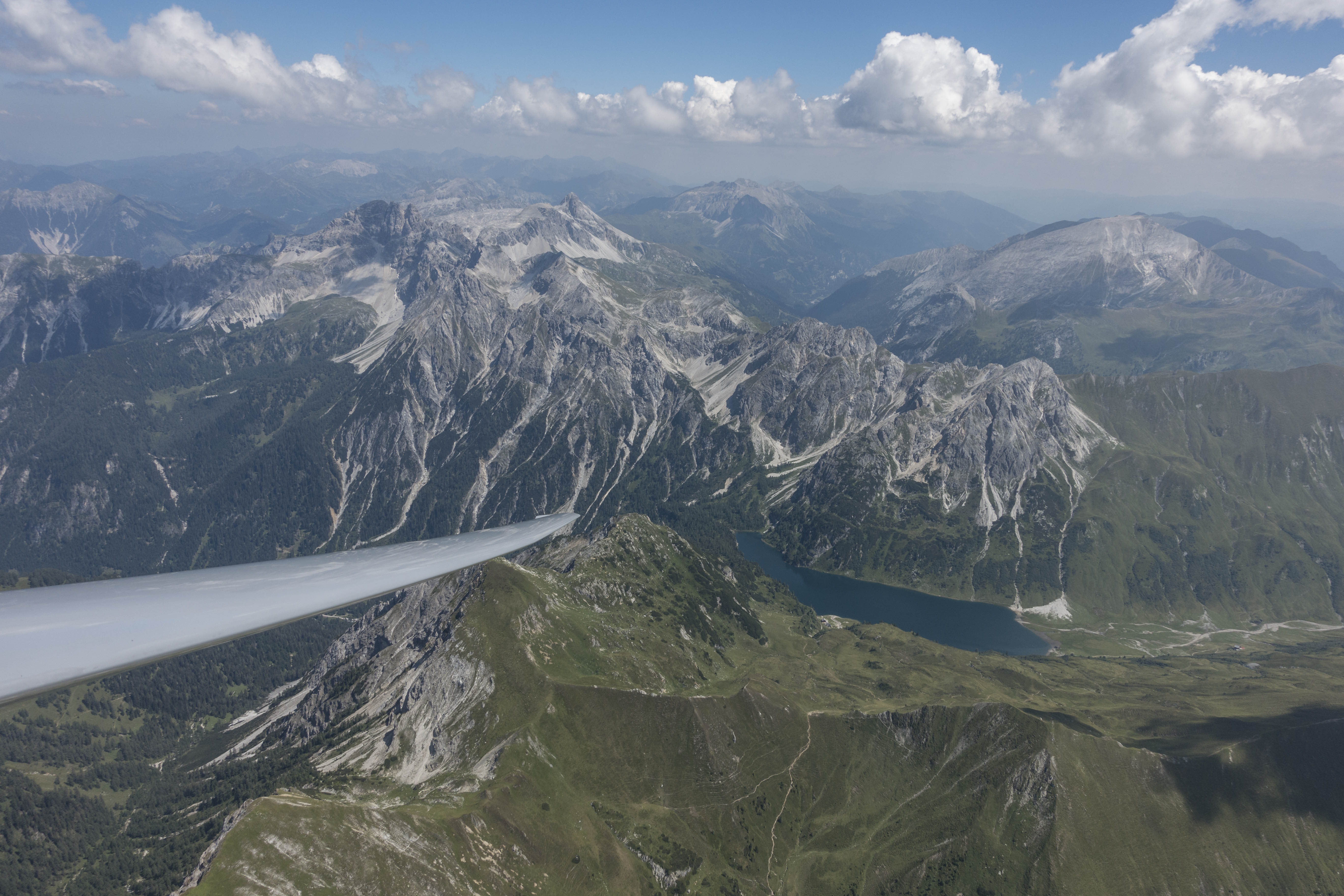
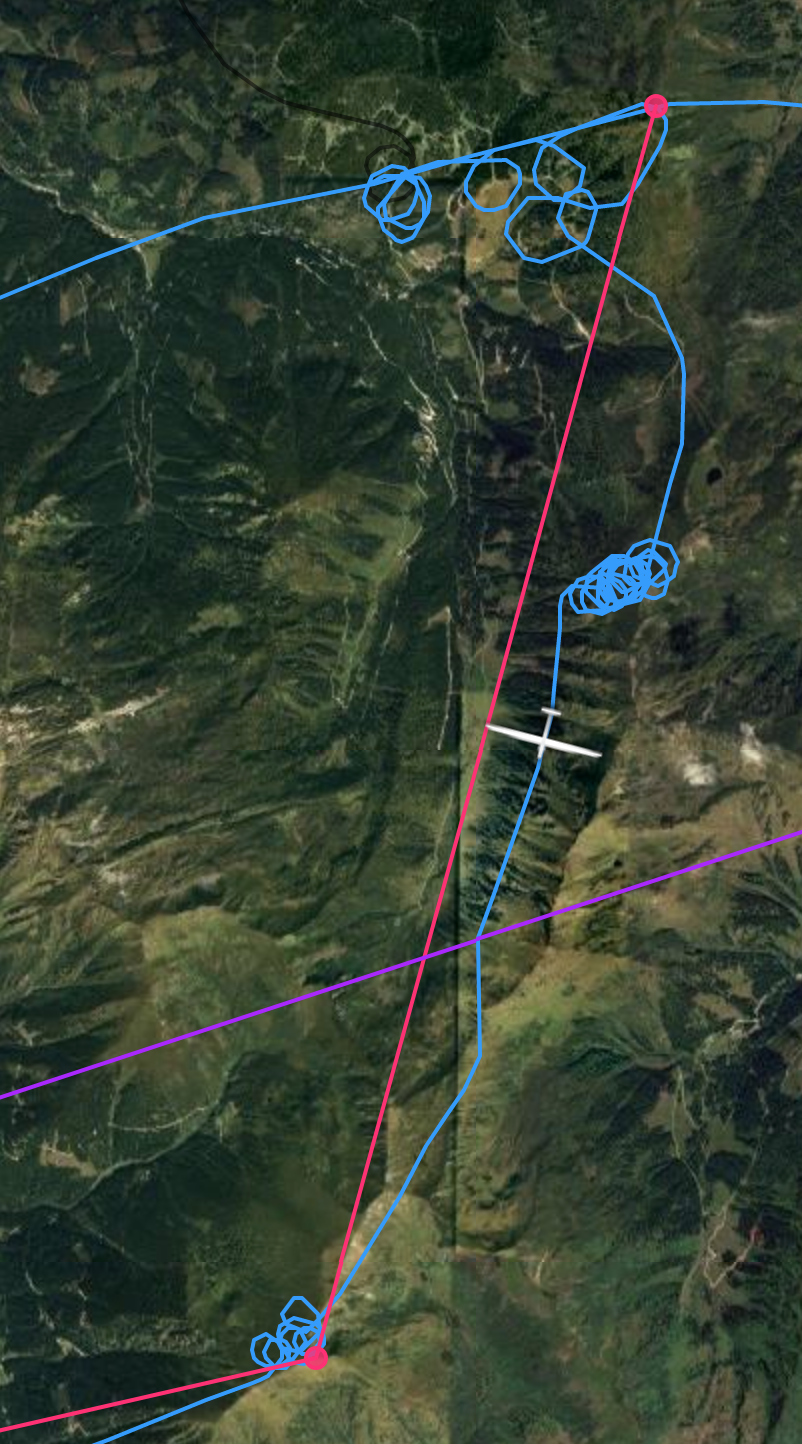
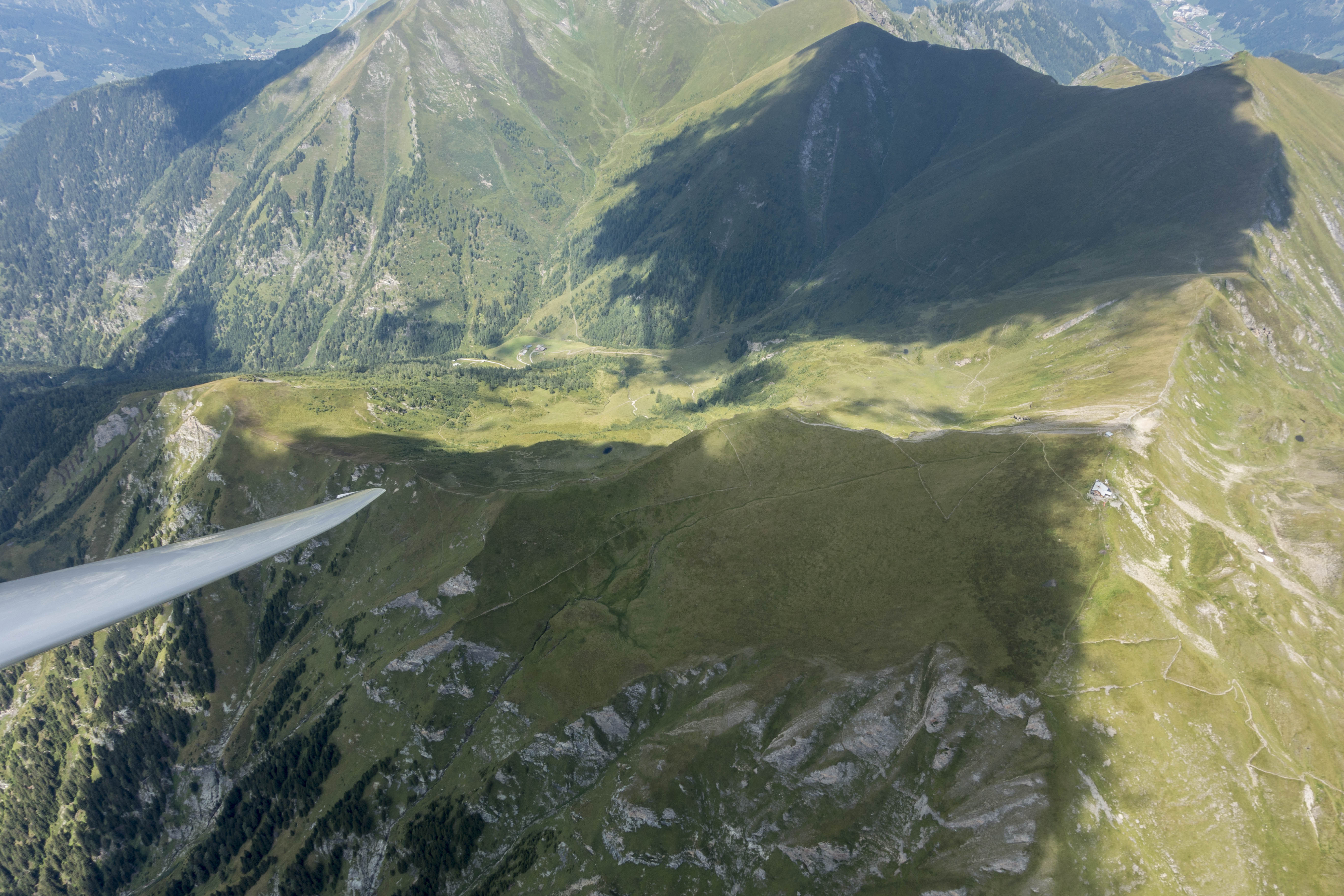
The flight track off tow shows how I’m following the ridge line. It’s often easy to maintain altitude when flying along the top of the ridge (up to about one or two thousand feet above the ridge) and it’s a great strategy to identify the best thermals – especially in blue conditions – as they tend to break off from spots directly along the ridge.View from Mausgarkopf (below) to the north across the Salzach Valley towards Hochkönig in the distance (above the wing tip) – near TP1. The line of clouds in the background is approx. over the border between Austria and Germany and confirmed the higher Cape index forecast for that area. The ridge line below the wing is a good example of where to find lift: the sun heats the slopes on either side of the ridge. That means air ascends on both sides and then lifts off the ridge top. The best thermals tend to be above the peaks.
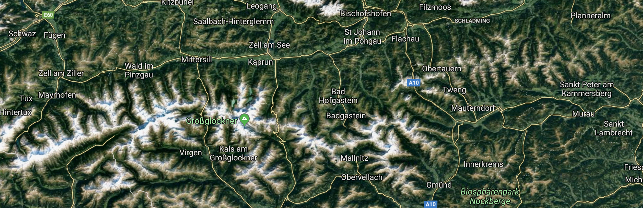
The main spine of the Alps resembles a giant fishbone. The spine itself is the ridge line in the center, which is in the direction from west to east. On either side of this main ridge are individual ridges (i.e. individual “bones”) protruding north and south with steep and narrow valleys in-between. Soaring usually involves a series of valley crossings as you’re flying from one of these bones to the next. More often than not, the valley crossings involve significant sink, while the lift is concentrated above the bones.
The fishbone structure of the Alps is easily visible in the Google Maps image.
Cloud-bases tend to be much lower than in the western United States and are often not far above the ridge line. Arriving below a ridge line can mean trouble (because usable lift is sometimes only available above the ridge-tops), so the safest strategy is to ensure that you’re high enough before leaving a ridge and heading through the sink to the next. Depending on the height of the cloud base and the performance of the glider it is often possible to skip one, two or several ridges before taking and centering another climb.
The village of Bad Hofgastein is below. In the distance is Austria’s tallest mountain, the Grossglockner.
In the western US my cross-country flight path is predominantly determined by the location of the clouds (and the terrain is often secondary – especially if it is many thousand feet below), whereas in the Alps, the terrain plays a much more prominent role in determining the optimal flight route. Obviously, that doesn’t diminish the importance of clouds as a marker of thermals. However, I have found that clouds that have formed directly above the ridges but have drifted away with the wind are often no longer marking usable lift. The ridge itself, on the other hand, is often still producing lift even if no cloud has yet formed to mark it.
Cloud shadows above another ridge. Compared to the Western US, the thermals in the Alps tend to be narrower and closer together.
Just before TP1 I found myself circling with three raptors – possibly small eagles – at an altitude close to 3,000m (10,000 ft). One of the raptors must not have attended flight school as it changed the direction of turn and started to circle in the opposite direction. I saw the bird coming straight at me and remember watching it to see how it would react to my presence. Fractions of a second later, just when I was surprised that it would dare come so close, I felt a bang as it collided directly with my left wing. My Oudie flight computer, which was only attached to the canopy via suction cup, fell off on impact and landed in my lap. My adrenaline rushed and my first reaction was a mix of empathy for the bird, which must have lost its life, and concern for the integrity of the glider and my own safety. I looked out at the wing and saw to my relief that it was still in one piece and that there was no obvious damage. I tested the controls and confirmed that the glider reacted just as I expected it to. Where the bird had struck, approx. 3m (10 feet) from the root of the wing, I saw a shiny spot on top of the leading edge of the wing. But there did not appear to be any dent or some other form of damage. Not knowing what else to do, I kept circling for another few turns, while I tried to decide whether to cut my flight short. After inspecting the wing as best I could and confirming again that everything was working just fine, I ultimately decided that there was no reason to change my flight plan, and thus I continued on route.
Flight path to and from the first TP. Flight from “bone to bone”: all climbs are directly above the ridge lines. I did not skip any of the “bones” to stay high and keep the airport in Zell am See within easy glide range as there are no viable land-out fields in this area.
I reached TP1 70 minutes after leaving the start line 85km earlier. The average speed of 72 kph was not particularly high but – except for the bird strike – my flight had been stress-free despite the relative lack of land out opportunities.
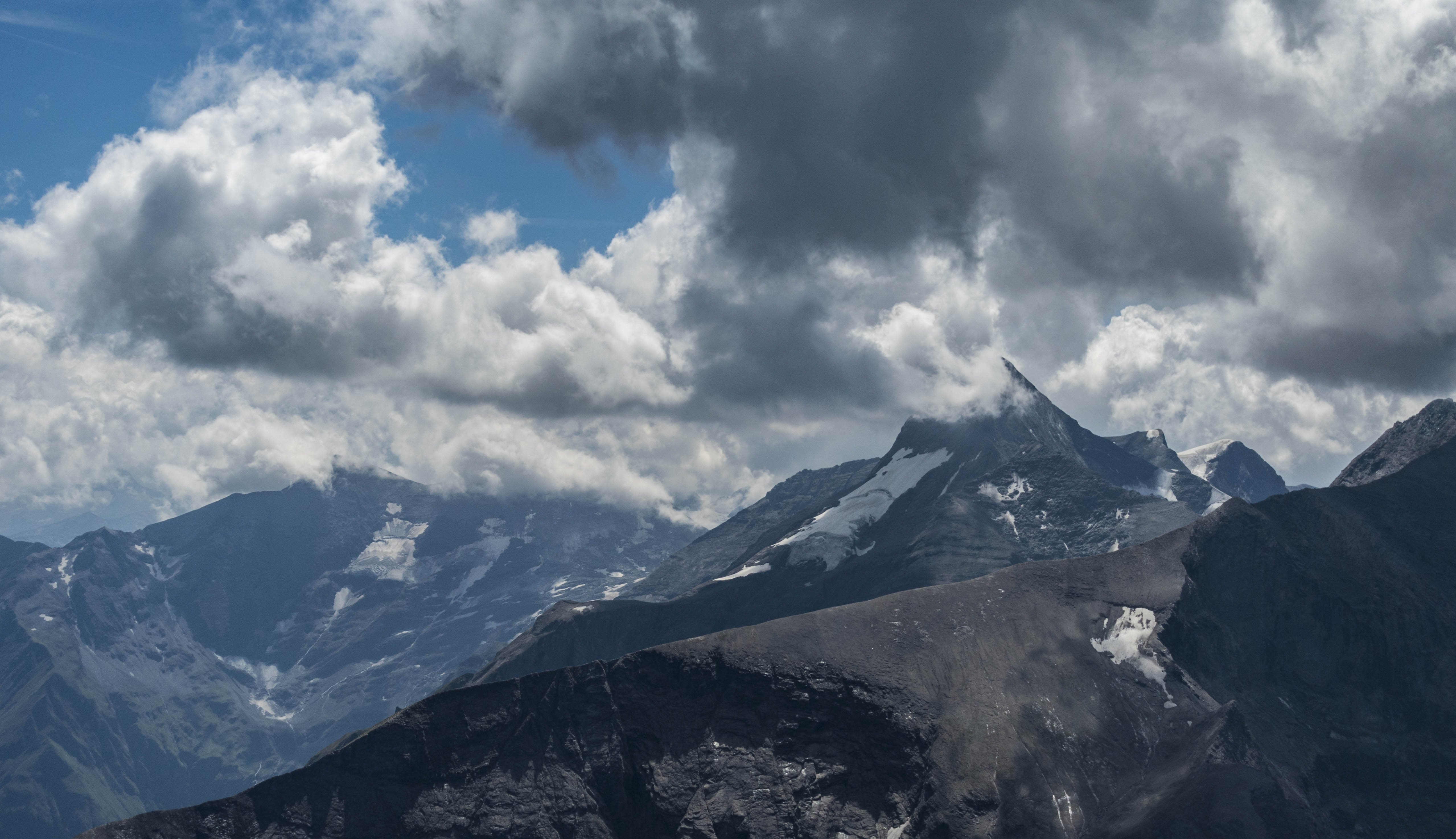
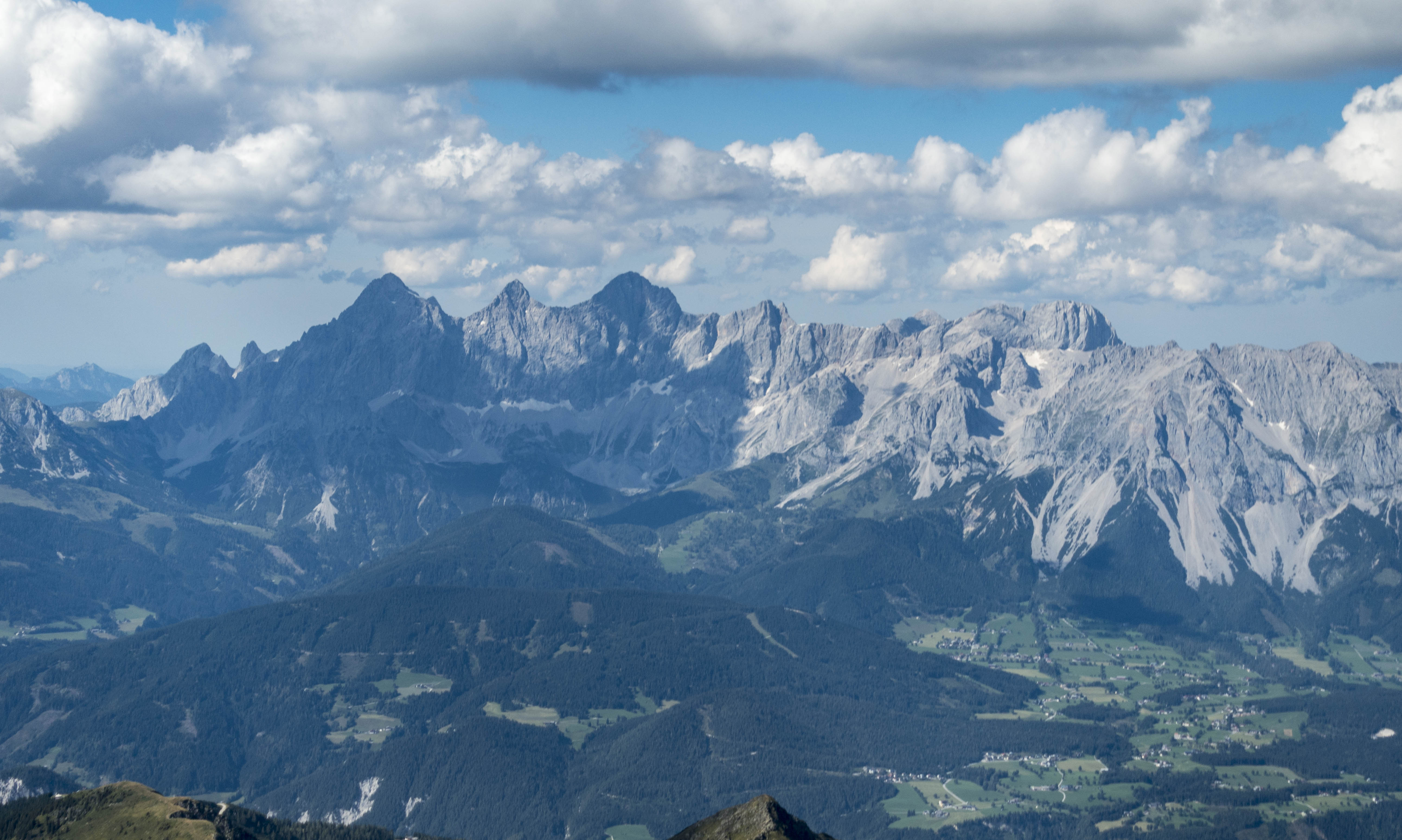
View of the “Glocknermassif” at the intersection of the provinces Salzburg, Carinthia, and Tyrol. Cloud bases were higher in this direction but the tallest mountains were obscured and the peak of the Grossglockner appeared to be out of reach.
TP1 was only 25km northeast of Austria’s tallest peak, Grossglockner, 3,798 m (12,460 ft) high. Cloud-bases at my location were around 10,000 feet. Even though the bottom of the cumuli was someone higher to the southwest, Grossglockner was obscured by clouds and appeared to be unattainable. There was a chance that the cloud base would lift later in the day but I decided to turn around and continue on task.
The posh skiing village of Badgastein is below. To the left are the high peaks of the Ankogelgruppe. The mountains in the distance on the far right are in Northern Italy.
Looking at the sky ahead of me I had to make a decision: should I continue on the north side of the central spine of the Alps (essentially retracing my flight path), or should I follow an almost continuous line of clouds that were perhaps 15-20 km further to the south. The southern route looked much faster and easier but I had not researched the land-out fields to the south (except for the airport of Mauterndorf where I obtained my winch training back in 1984). There was also a military air space around Zeltweg that I suspected to be inactive on the weekend, but I did not know the proper radio frequency to verify this. Looking at the clouds I could not tell for sure if I would be able to follow this line without encroaching on the military airspace. Thus I decided to fly on the north side. The main challenge was that the cloud coverage in this area had become very scattered with large blue holes on course. Well aware that my average speed would suffer, I decided to maintain my strategy of staying high and keeping known airfields and land out spots within glide range at all times.
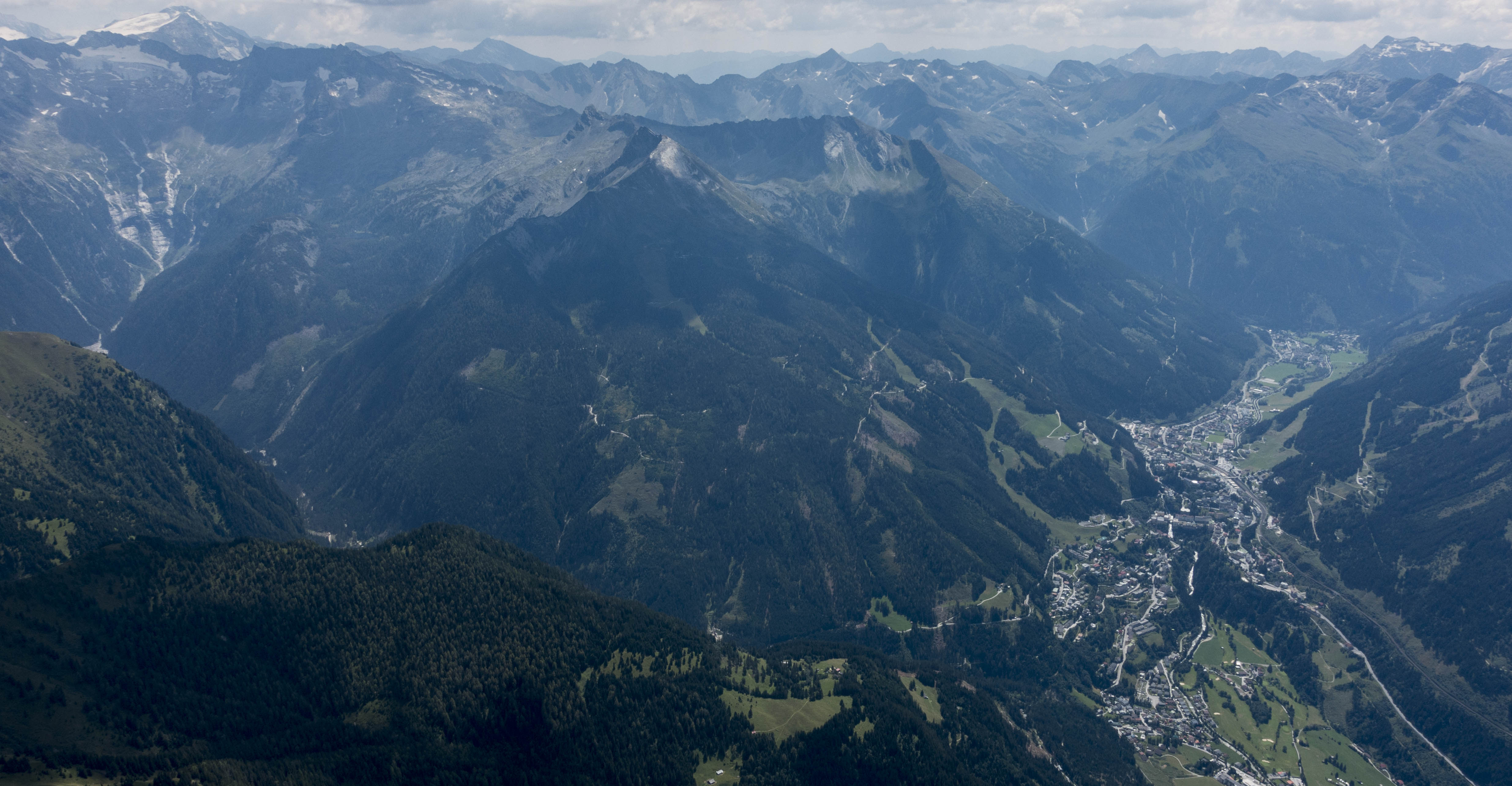
En route to TP2 looking NW. Big sections of the sky were blue along this stretch. The town of Trieben is below in the Palten Valley at the foot of the Reichenstein. The mountain to the right is the Hochtor. I crossed the valley approx. 15 km further southeast.
The execution of the plan worked as expected. I found practically all the climbs directly above one of the ridges, usually above one of the mountain peaks. There was a major variability in climb rates. Sometimes I would average 3-4 m/s (6-8 kts), sometimes as little as 1 m/s (2 kts) or even less. With mainly blue skies ahead of me there was no way of knowing how strong the next climb would turn out to be. My conservative strategy worked but my progress was predictably slow.
Just after crossing the Palten-Liesing Valley, looking north. The two parallel mountain chains in the background are traversed by the river Enns in a deep and narrow gorge – the “Gesäuse”, one of Austria’s National Parks.
Another obstacle on course was the crossing of the Liesing-Palten Valley. As I approached the valley I noticed a nice cloud right at the top of the divide at Wald am Schoberpass. However, as I got closer, the cloud was dissolving and I decided to stay on the west side, gain additional altitude, and cross further to the south.
Stadelstein, Hochstein, and Schwarzenstein are below. The open iron ore mine called Erzberg (“ore-mountain”) is visible center right. In the background are the Wildalpen (“wild alps”).
The crossing was uneventful. I ended up loosing less altitude than I had expected. But there was a lot of traffic in this area. I encountered seven or eight other gliders as well as hang gliders and paragliders. Most gliders in Europe are equipped with Flarm systems but hang gliders and paragliders are not. Traffic density in the Alps is orders of magnitude higher than in the American Rockies. Paying close attention is paramount at all times.
The free-standing mountain in the center is called Gößeck. The Liesing Valley that I crossed earlier is right behind it.
TP2 turned out to be well-picked as the sky further east was significantly overdeveloped with some emerging storms. I rounded it just before 3PM in the afternoon.
The road over the Präbichl mountain pass is below. This is were I learned to ski at the age of three. In the background is the Hochschwabmassif. TP2, the village of Vordernberg is in the valley just to the right edge of the picture. I considered pushing further east to extend the flight but this area seemed to be rapidly overdeveloping and so I decided to stay on route after rounding my turnpoint (indeed there were heavy rains in this area less than one hour later).
Cloud bases on the east side of the Liesing valley were significantly lower and now I had to transition back to the west side. Concerned about arriving too low I ended up wasting more time in weak lift before crossing the valley again. Again, my hesitation turned out to be overly conservative. After the crossing I quickly regained my altitude and was back at cloud base. I was also on final glide even though I had almost 50km in front of me.
I got another good look at the open iron ore mine of Erzberg as I circled above the Eisenerzer Reichenstein to gain height in advance of my second crossing of the Palten-Liesing Valley.
With my goal already made, I finally started to fly less conservatively. I flew 170 instead of 140 kph in-between thermals, skipped several ridges, and only took the strongest climbs. This strategy would likely have worked for much of the entire flight and would have resulted in a significantly higher average speed.
I finally reached the finish line after 4 hours and 40 minutes with an average task speed of 67 kph. Slow, but stress free, and happy to have completed my third pre-declared 300km goal flight and my first in the Alps. 🙂
After crossing the finish line I traversed the Enns Valley and continued to fly west above the tops of the Northern Limestone Range (Nördliche Kalkalpen). The Dachstein Massif is right in front.
After completing the task I took another climb and decided to add some sight seeing on the northern side of the Enns Valley.
The small remnants of the Hallstädter Glacier are on the right edge of the picture. When I was a little kid, the glacier was much thicker and wider flowing down into the valley below. Directly behind the peak in front I got a glimpse of the Hallstädter See (Lake Hallstatt), one of the most picturesque lakes in the entire Alps and a UNESCO world heritage site. Many of my American friends know it from their Sound of Music tours. 😉
I crossed to the Kammspitze, climbed again and headed west over the Scheichenspitze, the Hohe Dachstein (the highest peak of the day at 3,004m or 10,000 feet), and the picturesque Bischofsmütze. From there I retraced my flight path below the level of the peaks.
The prominent Bischofsmütze (Bishop’s Mitre) is in the center. The valley behind it leads to the city of Salzburg.
This final section turned out to be the most scenic and enjoyable part of the flight. I was flying along the steep south-facing cliffs of the Northern Limestone Range (Nördliche Kalkalpen).
The south face of the Dachsteinmassif was aglow in the early evening sun. The cliffs were still emitting heat and producing great upslope lift close to 6pm in the evening.
These cliffs had been exposed to the sun for the entire day and were radiating heat that caused the air to ascend along the slopes at 1-2 m/s allowing me to fly along the entire range at about 130-140 kph without loosing altitude. I even ended up climbing above the top of the Grimming, all in straight flight for about 50 km.
Nice view across the back side of the Dachsteinmassif. This high plateau sits about 6,000 feet above the floor of the valleys. You do not want to get caught low above it in a glider as there is no way out. The mountain hut below is the Guttenberghaus – you can see the very demanding hiking trail hewn into the cliffs at the bottom left of the picture.
Unfortunately, this last section did not count for the OLC Speed League because I omitted climbing back another 300-400 feet at the end (which had been my low point earlier). There’s no doubt that the final 2 1/2 hours were easily the fastest of the entire flight (probably averaging more than 100 kph).
The upslope lift along the cliffs took me above the top of the Grimming, the beautiful and prominent mountain next to the airport of Niederöblarn.
Overall, I had a very nice and relaxed flight in good conditions. I’m happy with the result especially considering my conservative tactics and the fact that my speed was right in line with that of others flying in this area on the same day. My flight track is here.
Lessons Learned
Follow the ridge lines whenever possible. When the sun heats the slopes on both sides of a ridge, warm air will ascend and converge right at the top. The best thermals will also almost always break away from the top of the ridges, usually above prominent peaks rising above the ridge line.
Lower may actually be faster. You may be able to fly directly along the top of a ridge line without losing altitude. This type of lift works best in relative proximity to the terrain, i.e. a few hundred feet above the ridge, but not several thousand feet above. This means you are likely to fly faster if you fly lower. This is at first counterintuitive because you can’t take advantage of the fact that the delta between IAS and True Airspeed increases the higher you fly. (This is a big contributing factor to the high average speeds in the American West.) Obviously, flying low above the ridges is mentally demanding and implies a reduced glide range requiring great situational awareness with respect to land-out fields and any terrain obstacles that may get in the way.
Arrive well above the ridge top when flying from “bone to bone”. The fishbone structure of the Alps makes constant crossings of narrow valleys inevitable if you want to get anywhere. Thermals almost always break away from the ridge tops and it may be difficult to find lift if you drop below ridge-line. So don’t, especially if the wind is insufficient to produce usable ridge lift helping you work your way back up.
Terrain is at least as important as clouds. Sunny ridge lines are constantly generating lift and new thermals will periodically break off from the ridge tops. These thermals can drift away with the wind and I have found that they often are no longer working once they have moved away from the ridge that spawned them. You are more likely to find lift in the blue above a ridge line than under an aging cloud drifting away from a ridge.
Rocks store heat extremely well. The south facing cliffs along the northern limestone range stored a ton of heat energy throughout the day. Flying in constant lift along the face of the cliffs at the end of the day was an amazing experience. However, remember that whenever you get close to terrain it is paramount to fly at a safe speed and to know the locations of cable cars and similar obstructions as they are very difficult to see from the air.
Birds can be stupid. I have always admired birds for their maneuverability and I never thought that a bird would be so stupid as to directly collide with a glider. But apparently that can happen. It’s a good thing that gliders are pretty sturdy. However, I hate to imagine what would have happened if the bird had collided straight with the canopy or the horizontal stabilizer.
Traffic! The air along the spine of the Alps is very busy – especially compared to the empty skies above the Rockies. During my flight I encountered at least two or three dozen other gliders in addition to para gliders and hang gliders. Especially the latter are not equipped with Flarm systems and it’s critical to keep your eyes outside the cockpit at all times and pay close attention to other traffic.
Mind the altitude rule for the OLC Speed League. The last 100 km of my flight were by far the fastest of my entire flight but they did not count for the OLC Speed League because I didn’t climb back to my previous low point during the flight. I would have scored considerably better had I climbed back another few hundred feet towards the end before coming back down to land. It is actually beneficial to have more altitude variability throughout the flight as this allows for more opportunities to calculate the fastest 2 1/2 hour segment of the flight. Something to remember.