
Our fourth SSB Condor Club Flight will not focus on flying a task as fast as possible. Instead, we will visit a number of potential landout fields along the southern Front Range.
Our flight will begin airborne at 1500m AGL above the Boulder airport and it will end at Kelly Airpark, home of the Black Forest Soaring Society, north of Colorado Springs. Inbetween we will try to put our planes down in ten different places ranging from perfectly landable to barely crashable.
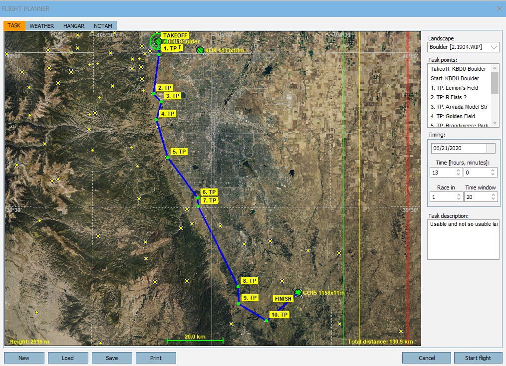
As we know there are not a lot of good places to land along this entire stretch. Except for Kelly Airpark, which is almost 20 miles east of the foothills and therefore of somewhat limited value as a land-out location if one were to get low along the Front Range, the only airstrip along this stretch is a privately owned airfield called Perry Park.
The other potential land-out locations are better thought of as Emergency Fields: they may be good enough to save your life, but there is not an insignificant risk that you may do significant damage to your glider and/or to yourself. To minimize this risk you really have to do everything right and you will also need a good amount of luck that wind and weather are favorable and that the “field” is free from obstacles at the time when you need it.
Nevertheless, it is useful to know where these places are and to attempt a “virtual” landing.
Before we do this we must remember that Condor has significant limitations when it comes to simulating land-outs because landscapes in Condor are static and Condor is necessarily much less granular than reality. This means that several real-world risks are not reflected in Condor at all and Condor cannot be relied upon for land-out field selection. To select real world land-out fields it is best to begin by researching potential fields on Google Earth (which is more granular than Condor landscapes but obviously still static) followed by driving up and walking them on the ground, and then practicing virtual landing approaches to the selected fields using Condor (or even better a real-world motor glider or powered aircraft). And even then you must still verify the suitability of a particular field from the air on the day you need it before deciding to actually land there.
Here are some specific examples of why Condor is NOT suitable for field selection:
- Power lines: most real-world power lines do not exist in Condor sceneries and Condor may show power lines in different places where they are in reality.
- Fences and ditches: in Condor there are no fences and most ditches that exist in the real world are not reflected in Condor either.
- Rocks and other obstacles: rocks or prairie dog holes in fields do not exist. Really big rocks may be noticeable due to their different color.
- Crops are obviously not reflected in Condor either. If the surface of a field is flat Condor will let you land in it even if in reality it may be full of tall corn stalks.
- Animals and farm equipment: these things don’t exist in Condor either. The same goes for people, vehicles, etc.
- Condor sceneries are based on satellite images taken at some point in the past. Condor may show a perfectly empty field but when you get there, you might notice that the field was replaced by a new housing development.
If Condor is not useful for landout field selection you might be wondering if this exercise is pointless. I don’t think so. I believe it is very useful to practice landing in fields that you have researched and pre-selected in reality. Landing virtually is totally risk free and you can do it over and over again in different wind and weather conditions. It can also help to develop important skills that are otherwise very difficult to obtain. E.g.
- Estimating field size and width from above.
- Estimating one’s height above ground.
- Assessing the slope of a field from the air.
- Determining the most appropriate landing pattern and approach to a field, especially if there are terrain obstacles.
- Experiencing the impact of the wind. (You can land in the same field many times with different wind directions and wind speeds.)
- Practicing energy management – you don’t want to arrive too fast or too slow but get the approach speed and the glide slope just right.
- Practicing spot landings when the field is very short and/or narrow.
- Practicing approaches over obstacles, possibly with a side slip to steepen the glide path when necessary.
- Practicing cross wind approaches and using different techniques such as forward slip and crabbing to counteract.
- Maintaining situational awareness, e.g. with respect to environmental effects such as lee side sink and turbulence, wind direction, complex terrain, etc.
- Condor also allows you to familiarize yourself with terrain that you hope to never see up close in real life because you will always try to fly high above. This could come in very handy when the unthinkable happens one day and you actually find yourself in much closer proximity to that terrain than you ever thought you’d be.
In other words: having landed in a particular field in Condor does in no way ensure that you can safely land in the same field in real life. However, should you have to land in a particular field in real life, your odds of being successful are (in my personal opinion) much higher if you have practiced it in Condor beforehand. E.g., if you can turn a 20% probability of being successful into a 50% or even an 80% probability, the practice will have been very worthwhile.
With all this said, here’s what you should do and expect for our virtual flight:
- On Thursday at 5:30 pm MDT, start Condor from the server list in the same way as all our other tasks. (Make sure that Condor is NOT running, then look for the line item labelled “SSB” and click on it. This will start Condor on your computer, load the task, and put you into the Flight Planner.
- Once you’re in the Flight Planner, familiarize yourself with the weather conditions. Most important is the wind direction and wind speed. (We will have a moderate wind from the north.) Don’t worry too much about the thermals for this flight – we will move quickly from one field to the next and use magic to gain height so we can fly fast (otherwise the entire flight will take too long).
- Go to the Hangar tab and select a glider. If you you own a real glider, I recommend that you pick one that most resembles what you fly in real life. (E.g., I will pick a Ventus 3 since it is most similar to my Ventus 2). If you fly the club Disci, the two most similar gliders are the Discus 2 and the LS8 neo (however, neither is part of Condor’s standard package). If you don’t want to spend any extra money, I suggest you use the Duo Discus (which is most comparable to our DG505) or the Standard Cirrus. I suggest you fly dry since you probably don’t want to land with full water ballast in small fields (you would not do that in real life either). The bigger and heavier the glider, the harder it is to land in confined spaces.
- Then join the game. You will be airborne 1500m AGL above Boulder.
- After your flight has started, press the “J” key on your keyboard. This will show the turnpoint helpers and make it easier to locate the landout fields. (You can press “J” again anytime to turn the helper off and you can also use the flight computer for navigation).
- Look for nearby thermals and hang-out near the Boulder airport until everyone has joined. Join time will be about 10 minutes, so try to join just after 5:30pm as soon as the SSB server appears on the server list.
- One minute after the end of join time, the start gate opens and we will all head out towards our first TP at Lemon’s Field. This will be our first landout field.
- When you approach a field, look at it from above to assess it. How long and wide is is? Where is the wind coming from? Is there a slope? What is the best landing direction? Are there obstacles in the way – in the air and/or on the ground – how can they best be avoided? What does the surface look like (is it even/uneven), are their color changes that suggest ditches or other obstacles?
- Once you determined how to land in it, plan your pattern/approach, go through your final landing checklist (wind, speed, gear, flaps, spoilers) and try to safely land in the field.
- Many fields are small and allow only one glider in the field at any time. If that’s the case, press “Q” once you have landed safely. This will instantly put you back in the air and clears the runway so others can land as well.
- If you crash, press “Q” and feel free to try again. Remember that Condor will put you outside the cockpit if you have crashed so you also need to press “F1” to get back into the cockpit. Once you’re back in the air, retract your gear, close the spoilers, and reset your flaps if you have them. (Follow the same procedure if you have a mid air collision with anyone else.)
- You can hang out in the air and watch other people land, try again, or, if you like, you can already move on to the next field.
- Once we’re done with a particular field we will all move on to the next one and follow the same procedure. We will try to fly fast from field to field and press “Q” to gain extra altitude as needed so we can press on quickly. (Condor has no function for magically jumping to different GPS coordinates so we have to cover the distance between fields by flying.)
- If it gets too long, you can leave the flight at any time and perhaps try again later on your own. The flight will not be scored.
Please Join Us on Teamspeak!
Maybe even more so than in the past, it will help if you join on Teamspeak so we can have a live conversation while we are flying. This way we can discuss what we learn and everyone can share their thought process for why they approach a field in a certain way. Also, if you are aware of other (and perhaps better) fields along the route that I did not include in the flight plan, it would be great if you could point those out as well.
The instructions for joining Teamspeak are here.
After our flight, I will provide a link to the Flightplan so you can keep practicing if you like. I have also put together plans for other landout flights covering the Northern Front Range, South Park, and the Foothills west of Boulder. We can decide if we want to do those together or else, I can just provide the flight plans after our flight and you can practice them on your own.
DISCLAIMER: this should be obvious, but I DO NOT and CANNOT take any responsibility for the practical usability of any of the information shared in real life. In particular, I do not suggest that it is possible for anyone to land a glider safely in any of the fields that are part of any of the flight plans for Condor. Everyone must do their own research and and determine they can safely land with their particular glider in a particular field at that particular day and in actual conditions.