Skip to content
Soaring – Chess in the Air

Soaring – Chess in the Air

A Glider Pilot Learns to Play Mother Nature

  • Home
  • Locations
    • Boulder, Colorado
      • Flight Preparation
      • Colorado Soaring Area Map
      • Colorado Waypoint Files
      • Boulder GlidePlan Map 1:27
      • Launching from Boulder
      • Standard Tasks and Badges
      • Groundbreaking Flights
      • Boulder Triangles
      • Colorado 1000+ km Flights
      • Colorado Outlanding Fields
        • Fields Overview
        • Field Evaluation Criteria
        • Caribou Springs Trail
        • Yellowstone Road
        • E of Dry Creek Reservoir
        • Lazy W (Pvt)
        • 2 NW of Lake Loveland
        • Christman Field (Pvt)
        • Horse Farm
        • Buckeye Fields
        • Cherokee Park Road / 287
        • The Buttes
        • Pahlow Field
        • Brubaker Lane
        • Sand Creek Road
        • Laramie River Valley Farm
      • The Colorado Fourteener Challenge – One Of Soaring’s Greatest Adventures
      • Condor Exercises
    • Albert Lea, MN
    • Montague, CA
    • Nephi, Utah
    • Niederoeblarn, Austria
    • St. Auban, France
  • Lift Sources
    • Ridge
      • What Is Ridge Lift?
      • What Conditions Produce Good Ridge Lift?
      • Why Is There Wind Anyway?
      • Direction And Strength Of The Wind
      • How Do I Fly In Ridge Lift?
      • X-Country In Ridge Lift
      • Risks And Risk Mitigation
      • Forecasting Ridge Conditions
    • Thermals
    • Convergence
    • Wave
      • What is Wave?
      • What Triggers Waves?
      • How Can I “See” Wave?
      • How Do Wave and Thermals Interfere?
      • How Do I Get Into Wave?
      • How Do I Fly in Wave?
      • How Do I Fly XC in Wave?
      • What Are The Risks?
      • How Can I Forecast Wave?
  • Safety
    • Soaring Risks and Risk Mitigation
    • Passenger Briefing
    • Emergency and Land-Out Equipment
    • Landing Out
  • Other Pilots
  • More To Learn
    • Inspiration – Videos That Will Get You Hooked
    • Soaring Basics
    • Soaring Podcasts and Other Stories
    • Book Reviews
    • Tips for Clubs
    • XC and Contest Flying
    • Other Information
  • About Me
    • My Flights
    • My Videos
    • My Presentations
    • My Tools
    • My Professional Bio
    • My Colorado 14ers
    • Aircraft Flown
    • Live Tracking
    • Contact Me

The Five Local 14ers

Last week we flew over the Five “Local” 14ers:

  • Longs Peak
  • Torrey’s Peak
  • Gray’s Peak
  • Mt Bierstadt
  • Mt Evans

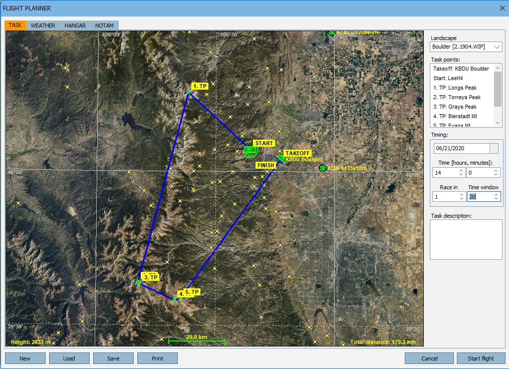
The results are here.

Anyone who wants to fly (or re-fly) the task can download the flight plan here.

The briefing for the entire series of the Virtual 14er Safari Cup is here.

Subscribe to Blog via Email

Enter your email address to subscribe to this blog and receive notifications of new posts by email.

Search

  • Send Me an Email
Proudly powered by WordPress
 

Loading Comments...