Each year the Auxiliary Sailplane Association (ASA) organizes the Parowan Soaring Camp in Parowan, Utah. The following resources are intended to help participants prepare for flying in one of the best soaring locations in the United States (and the world).
Area Overview
When flying in the mountains “out west” one has to content with hostile terrain and very remote areas, often dozens of miles away from the nearest human habitation or even the next road.
Thorough preparations are therefore essential. The resources below may be an aid in this process. However, be aware that ALL INFORMATION ON THIS PAGE MAY CONTAIN ERRORS and IS NOT KEPT UP TO DATE. DO NOT TRUST IT AND ALWAYS ONLY RELY ON CURRENT AND AUTHORITATIVE RESOURCES FOR FLIGHT PREPARATION.
Parowan Soaring Map
The following custom Parowan Soaring Map contains information that may be helpful for task planning:
- Mountain ranges and other topographic features
- Public airports and private air strips – NOT ALL AIRPORTS ARE SUITABLE FOR ALL GLIDERS. Some airports may no longer exist. Do your own research based on current and authoritative sources only!
- Mountain tops and other waypoints for task planning
- Potential landout fields (unverified and possibly outdated; they may only be usable by some pilots or some types of gliders or not at all – DO NOT TRUST THEM!).
- Emergency landouts (if your only other chance is to bail out; expect to get hurt and that your glider will be destroyed – NEVER PLAN TO USE ANY OF THEM)
- Key Airspace information (Class B, C, and D; SUA, Grand Canyon Special Use Airspace)
The map may be easier to view if you open it in a separate browser tab.
Parowan Waypoint File
This Parowan Waypoint file in .CUP format corresponds to the Soaring Map above. Before you add it to your flight computer YOU MUST take note of the following KEY DISCLAIMER:
The Waypoint File is solely intended for sporting purposes and MUST NOT BE USED FOR NAVIGATION OR FLIGHT PREPARATION.
Note: landout locations may be preceded by an “x” before the name and may have a question mark “?” in the name followed by codes. The following codes are used:
- ?s: surface could be a concern (e.g. tall crops, ruts, soft, possibly flooded, etc.)
- ?l: length of surface may be insufficient to stop even when landing well
- ?w: width is a concern (e.g. trees, brush, berms to the side of the runway)
- ?^: ground obstacles could be an issue (e.g. irrigation equipment, lifestock, etc.)
- ?a: landing approach is a concern (e.g. terrain, power lines, etc.)
- ?@: road access could be a problem (especially for a glider trailer)
IMPORTANT: THE ABSENCE OF A QUESTION MARK or QUESTION MARK CODE DOES NOT IMPLY THE ABSENCE OF PROBLEMS OR DANGERS.
Landing away from public airports may be considered trespassing and is inherently dangerous, possibly resulting in property damage, injury, or death. The condition of fields changes all the time.
Location names preceded with “xx” are for emergencies only and MUST NEVER BE CONSIDERED LANDABLE. It may be better to bail out with the parachute than to use them.
HIgh Level Area Overview
When reviewing the Parowan Soaring Map and the Waypoint file, keep in mind that some parts of the soaring area are much safer and more accessible than others. Generally, flying within the area NNE of Parowan can be done reasonably safely because good public airports or safely landable fields can usually be kept in glide distance (especially when cloud bases are high as is often the case.
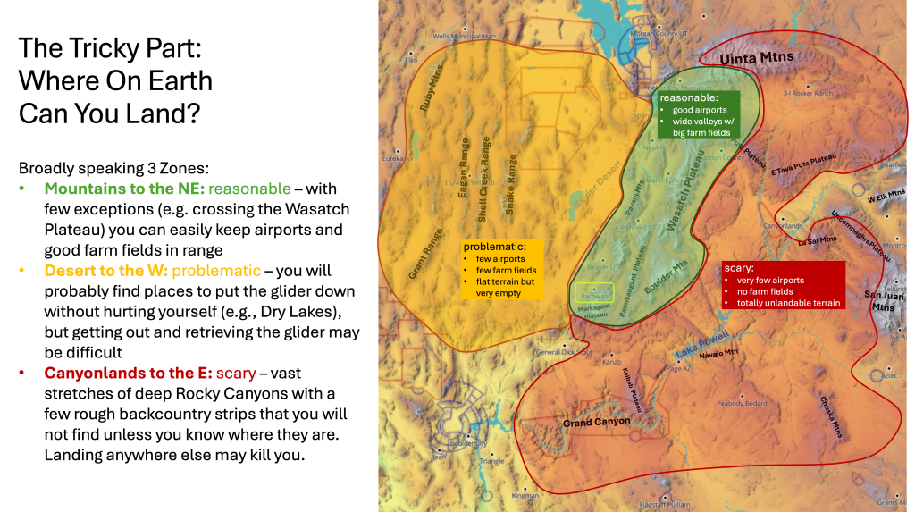
The area to the west and northwest is much more problematic. Airports are spaced much further apart and the terrain is very remote.
The area to the east of the Wasatch Plateau is perhaps the most inhospitable and most remote area in the United States outside of Alaska.
Pete Williams Trophy
The ASA conducts an informal and voluntary contest to determine the annual winner of the Pete Williams Trophy. This is a fun contest where the winner is the one that achieves the highest score overall based on their best scores in 4 categories:
- Distance from home
- Triangle Distance
- OLC+ Total Score (based on six legs, i.e. max 5 turn points)
- OLC 2-hour speed (based on four legs, i.e. max 3 turn points)
To participate you need an OLC account and upload your flights to OLC.
If you’re thinking of participating, download the rules.
Daily Task Flying
In 2025 we will attempt to set daily tasks to conduct an informal daily competition on WeGlide. This is purely for fun for those who wish to participate. Flying these tasks is NOT REQUIRED to compete for the Pete Williams Trophy.
We will use the “Local Competition” feature of WeGlide to score the flights. It only requires that you have a free WeGlide account and that you upload your flights to WeGlide (in addition to uploading them to OLC). You do not even need to make a task declaration. WeGlide will automatically score all flights if the task is completed. Glider handicaps will also be accounted for automatically.
To participate you will need a WeGlide account and upload your flights to WeGlide as well.
- Open a free Weglide Account at https://www.weglide.org/
- Enter your SSA credentials to WeGlide if you want to make free use of some premium features. (Task scoring will work even if you don’t do this). This is explained here: https://www.ssa.org/weglide/.
- Set your LXNav computer to automatically upload your flights to WeGlide. (Or do it manually). E.g., you can also easily upload your flights directly from an Oudie N.
- Optional: install the Parowan Waypoint file (see link above). This is not required for task flying but it may help if we all use the same names for turnpoints etc.
- Expect to receive an email each morning with the suggested task of the day. (Task flying is optional.)
IMPORTANT: NEVER attempt to fly a task if you do not consider it safe to do so for whatever reason. As Pilot in Command you are solely responsible for the safety of your flight.
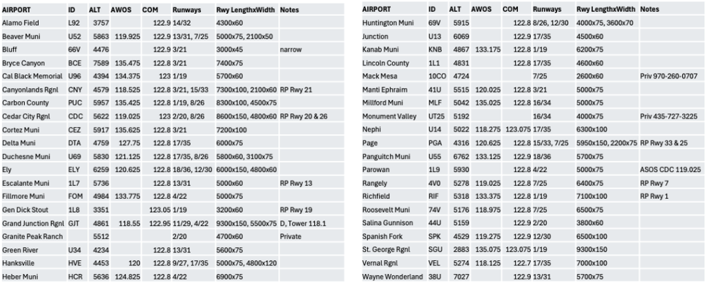
Airport Cheat Sheet
If you’re like me, you may want to have a paper list of airports with radio frequencies and runway information. Like all other materials above, it may contain errors and be outdated. Use at your own risk: