

We’ve not had a ton of luck with the soaring weather on recent OLC weekends and, as a result, our club, the Soaring Society of Boulder, has been losing ground against Moriarty, which is now comfortably leading in the US Gold League.
Unfortunately, this weekend didn’t look much better. A cold front was projected to move in on Saturday bringing thunderstorms and heavy rains to the Front Range.
Based on a detailed review of the forecast from Skysight, I estimated that there would be a narrow soaring window ahead of the front, from about 11am to 2pm, to get some miles under our wings and some points onto the score sheet. The best location to fly would be – once again – on the west side of the classic convergence line that would form parallel to the mountains, this time pretty far in the west: about half-way between the Peak-to-Peak Highway and the Continental Divide.
Getting there would almost certainly require a deep mountain tow as the morning thermals above the eastern foothills were projected to top out at about 1,000 – 2,000 ft AGL – too low for comfort when it comes to pushing all the way back towards the mountains, well beyond the Peak-to-Peak Highway.
When I got to the airport at 10am, some clouds had already started to form southwest of the Flatirons, consistent with the forecast, which projected that area to overdevelop first. They looked reasonably close to me and so I decided to get the Discus prepared as quickly as possible. Ay 10:45am I was ready to launch.
I asked John Lewis in the Pawnee for a tow to the south. Except for one or two weak bubbles directly above the ridge line of the Flatirons, the air was completely still for a long, long time. As we crossed Thorodin Mountain we reached the eastern edge of the first cloud, but the air still gave no hint of any movement. We reached Central City and I asked John to continue further west. We were already above 12,000 ft and I was determined not to go off tow until we hit lift somewhere. Otherwise, I would have no choice but to glide right back all the way to Boulder…
I had convinced myself that lift would come as soon as we got to the western edge of the clouds as this would mark the location of the convergence. We crossed Bald Mountain, 3 miles northwest of Idaho Springs, and the edge of the cloud was finally getting close. My hand had been on the release knob for a while but now it had to come … any second now … and – whoosh, the vario pegged solid at plus 10kts. One second, two seconds, three seconds, the lift is still there, and click, I’m finally off. 13,000 feet. My longest and highest tow so far by a wide margin.
I rolled into a tight circle and the averager shot right away to 10.5kts. Wow – now we’re getting somewhere! I noticed that I was drifting east – a great sign, for it meant I was definitely on the right (i.e. west) side of the convergence line. A few more circles and the lift weakened. I shifted a few miles north where the clouds looked even more promising and I connected again with a 10 knotter. Just two or three minutes later I climbed through 17,000 ft and was perfectly connected with the convergence line.
The only problem was that I had been on tow forever, well beyond the OLC start cylinder. I.e., until I got back within 15 km of Boulder I wouldn’t get any points for the flight! Only then did it sink in how far I had towed. I was 40km away from Boulder. The nearest point within the start cylinder was Gross Reservoir, still 25 km away!
There was only one thing I could do about that: put the nose down, head towards Gross Reservoir, “dip” into the cylinder, turn around, and come right back to the convergence. I was at 17,500 feet so I definitely had the altitude to do it.
With the wind in my back, it took me just over 7 minutes to cover the 25 km to Gross Reservoir, and another 9 minutes to get back, heading into the wind. The round trip had cost me 4,300 feet of altitude that I had to gain back. I climbed 2,000 feet circling above the Eldora Ski Area before continuing south, flying slowly to climb in straight flight.
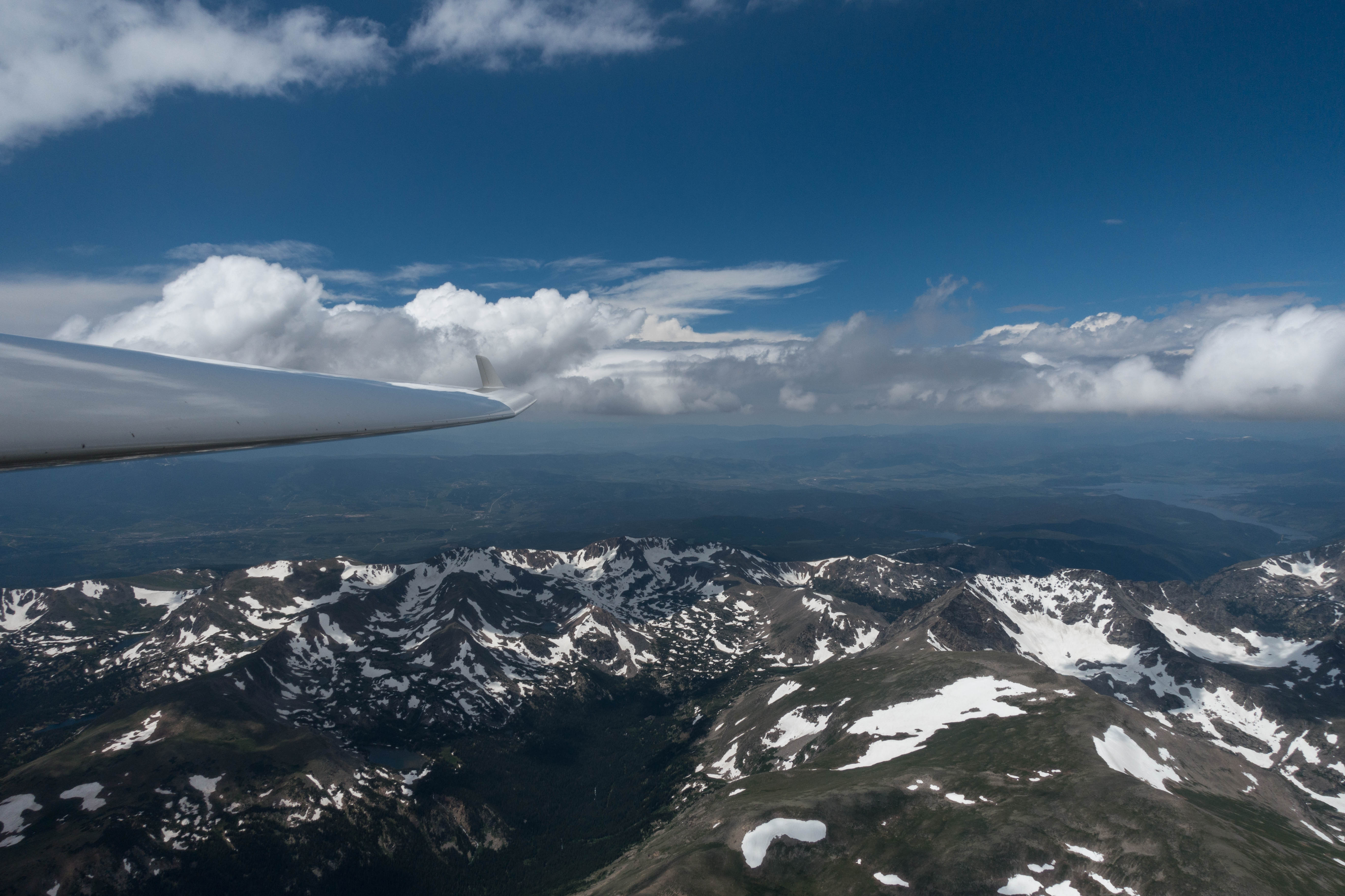
The convergence line took me straight over the Continental Divide, across James Peak, Mt. Eva, Mt. Flora, and Colorado Mines Peak. The sky was already overdeveloped in this area so I decided to turn around and continue northbound along the convergence.
I covered the next 67km without a single turn and without losing altitude at an average speed of over 150 kph, the fastest segment of my flight. West of Estes Park, I decided to once again change directions and head south again. Conditions softened somewhat and I ran into a few patches of sink near Longs Peak that required some thermalling to not fall out of the working band.
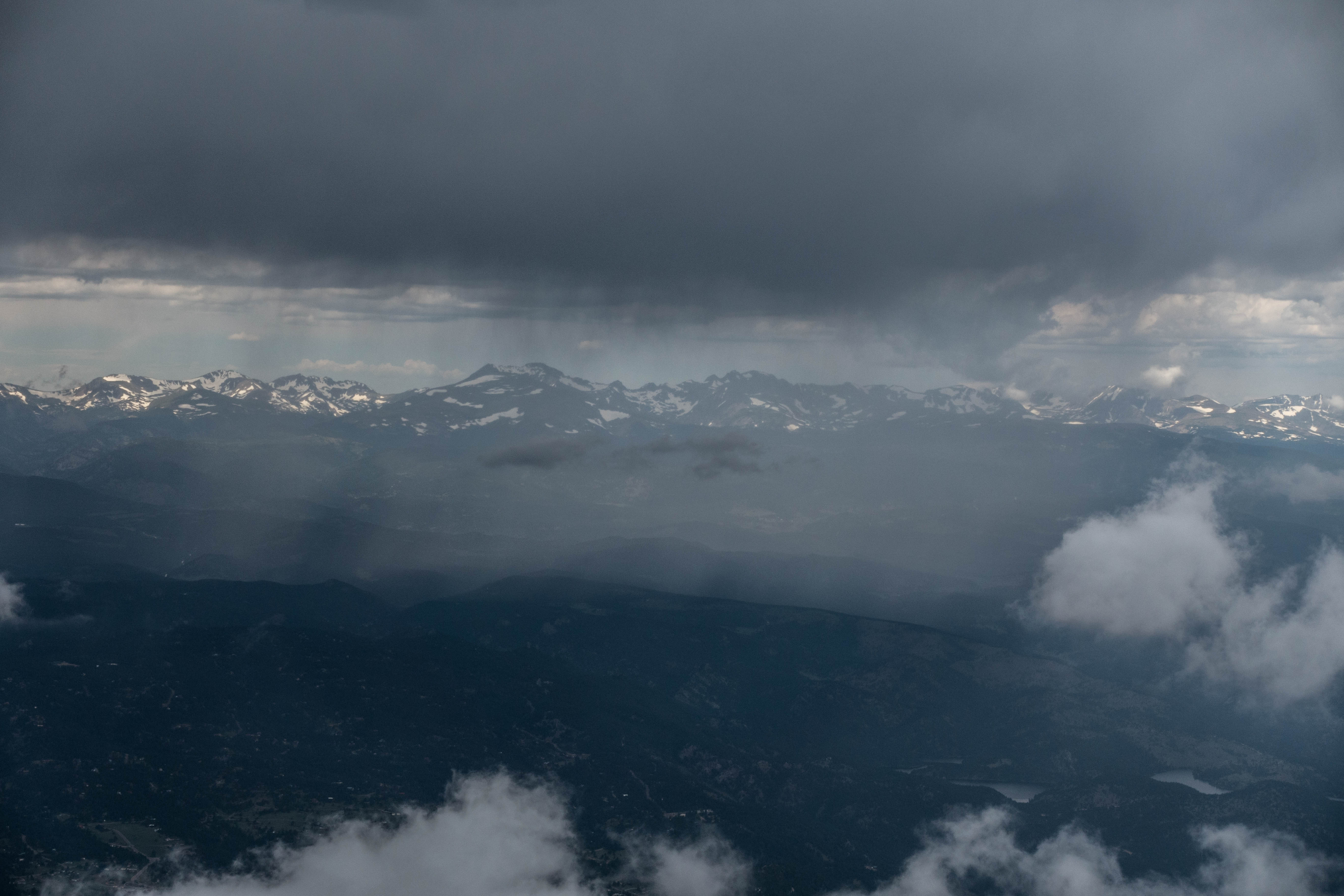
The sky ahead rapidly darkened and I could see several flashes of lightning near Mt Evans. Intense virga and rain lines started to appear and when the lightning got within about 10 miles of my position I decided to once again change directions.
Conditions were still very strong and they looked even better on the west side of the divide. However, I did not want to push further west as I had no interest in landing out. My main focus was now to watch the development of the sky and to leave the Continental Divide in time before any of the storms would impede my return route or get close to Boulder.
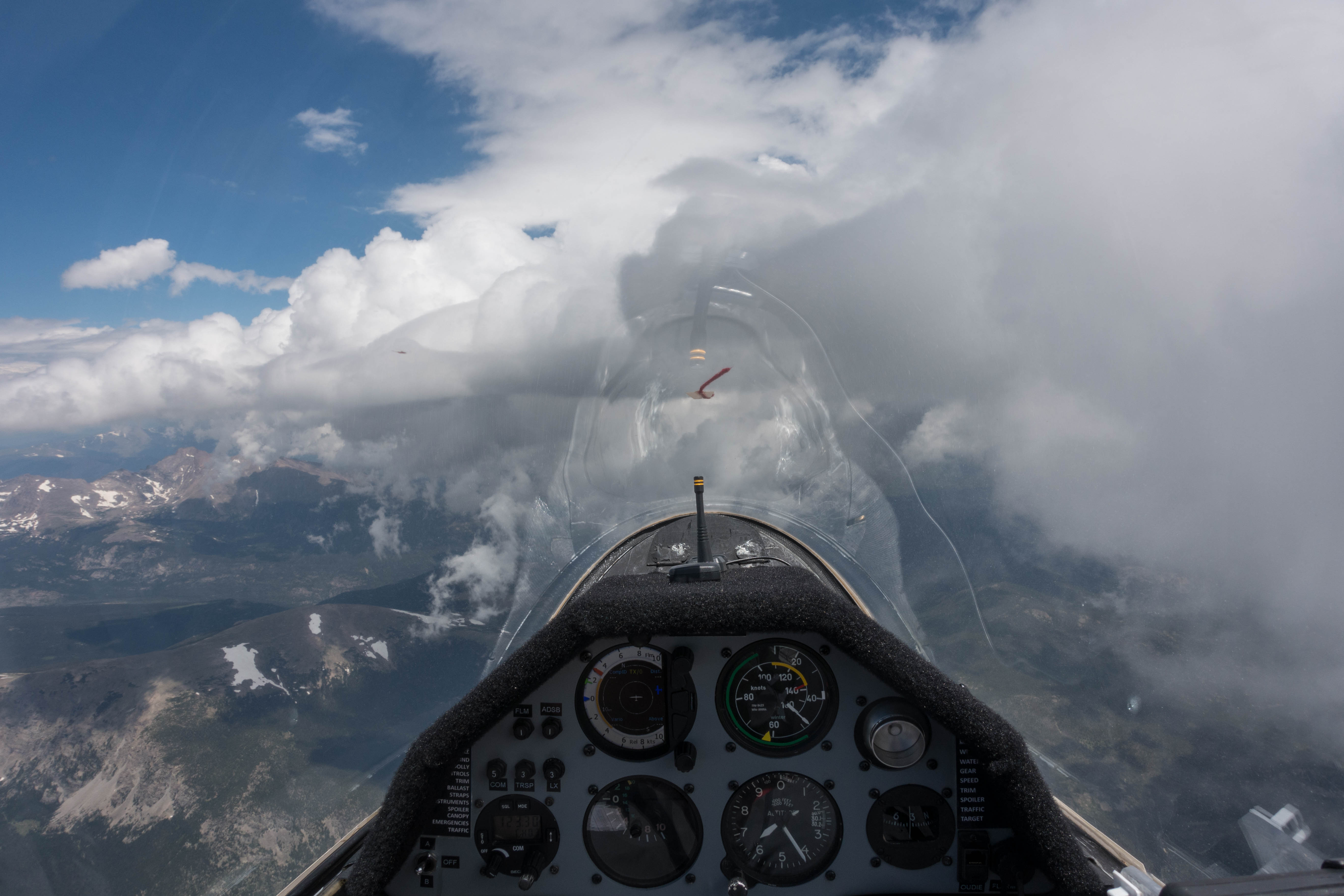
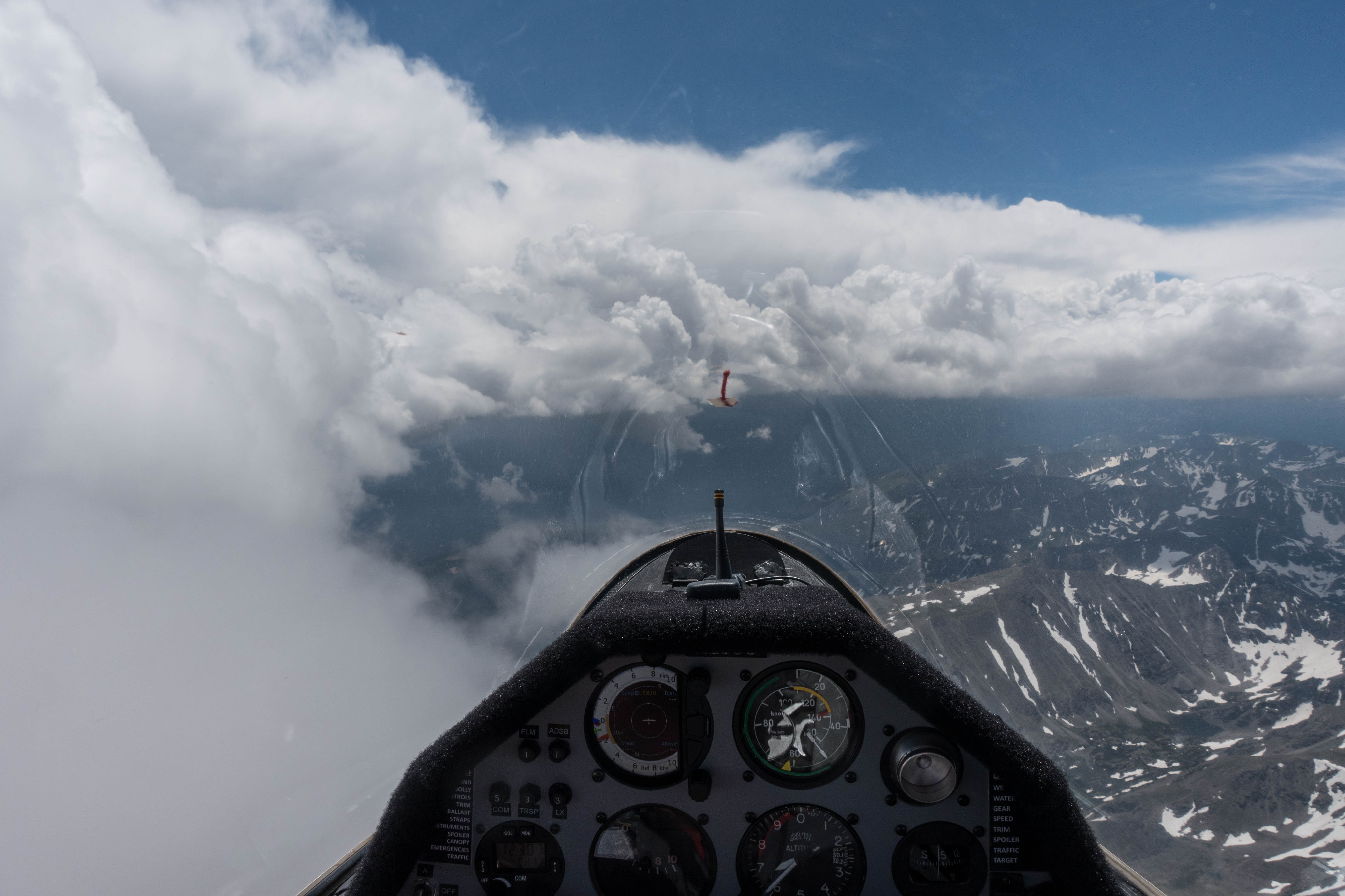
This is when I noticed a very interesting transformation in the looks of the clouds ahead. Where there had been typical cumulus clouds with high cloud bases to the west and low hanging curtain clouds to the east, marking the convergence line, the cumulus clouds ahead started to take on the form of lenticular clouds with very smooth forms on their western edge.
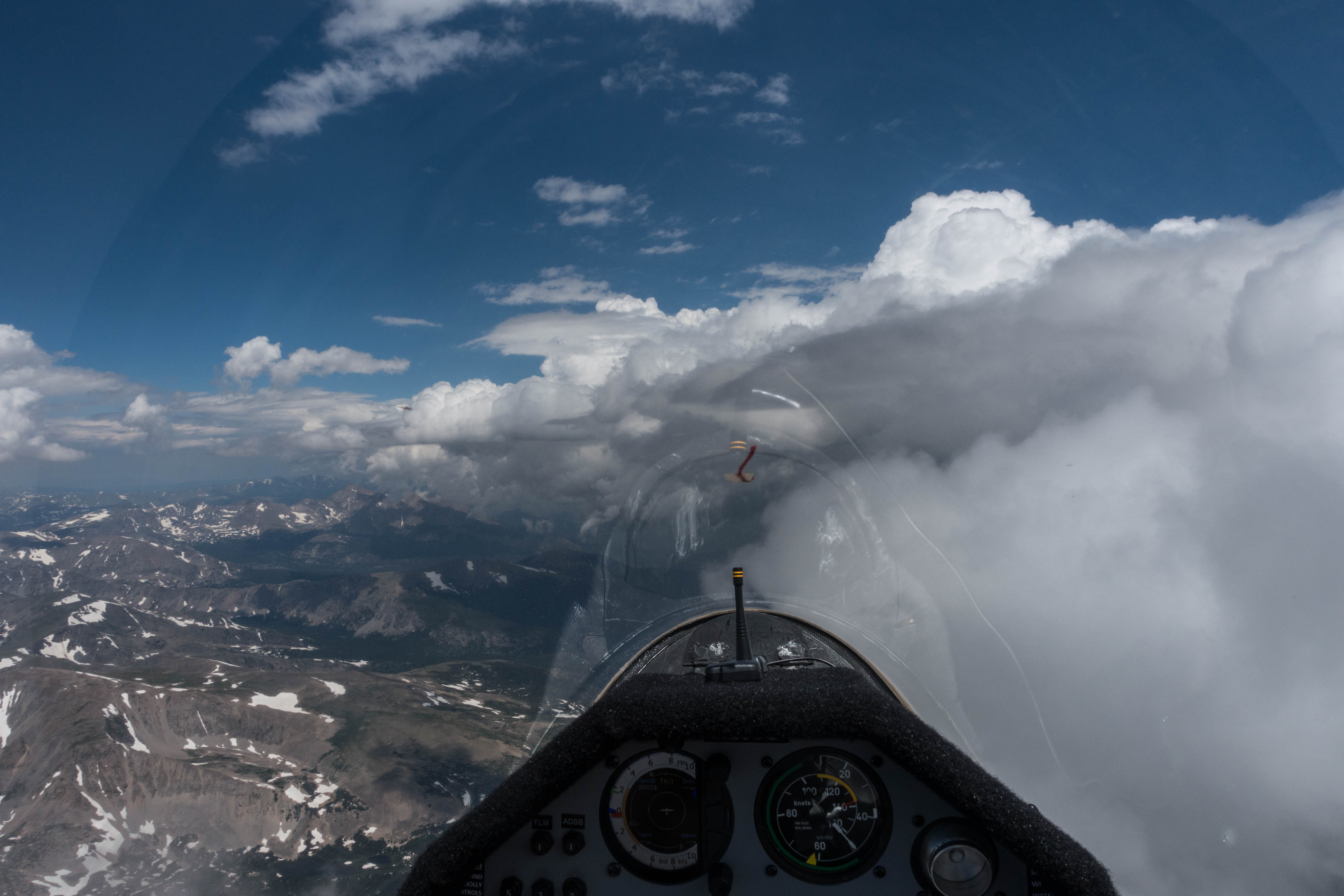
Granby was to my left, in easy glide range and clear of clouds, offering a safe escape route if necessary. I simply had to explore this phenomenon ahead of me. I continued to fly along the convergence, only now I tried to stay just to the west side of the edge of the clouds, flying in the blue.
And, just as I had hoped, I suddenly noticed the air going completely still while I was still climbing. I had entered a laminar air flow on the west side of the convergence line. It had all the characteristics of weak wave lift. I noticed that the winds, which had been around 10 kts or less for most of the flight so far, had picked up to 20 kts from the west. This was fascinating and felt surreal.
It clearly wasn’t classic mountain wave. I was right above the divide. There was no way that the air had descended on the back side and was pushed up again as a result of rapid warming in the lee of the mountains as would be typical for wave. I also wasn’t in ridge lift from the Divide for the line of lift followed the shape of the clouds, not the shape of the ridge.
My flight track was akin to ridge flying at the “slopes” of the clouds but the lift was not like ridge lift at all. Ridge tends to be rough and uneven. This lift was smooth and laminar. The vertical component was small, approx. 2-3kts netto, which translated to a climb rate of approx. 1 kts at minimum sink speed. But climbing in glassy air along the edge of the clouds was amazing.
I enjoyed this for a while but at the same time kept wondering about my flight path back to Boulder. Surfing along the clouds, I could not see the sky to the east. 10 minutes earlier I had observed more and more low clouds forming out in the prairie. I was aware of the virga and rain lines from the overdeveloped area to the south gradually moving east north east. I was also aware of OD to the north, though none of it was visible from my position. The only reassuring thing was the blue sky above Granby.
I still did not want to land in Granby. AWOS of Boulder indicated good conditions on the ground with light winds and good visibility. So I resolved to descend to get a better view of the sky below the clouds to the east. When I could finally see that I still had a safe and unobstructed path back to Boulder I did not hesitate and started my return.
I could even add a few more OLC points by closing my triangle over Gross Reservoir and heading towards Golden before returning to the airport for a safe and uneventful landing in calm conditions 10 minutes before 2pm. I even had just enough time to pack up and secure the plane without getting wet, leaving the airport just as the rain reached the field.
This flight was expensive (due to the high tow) but fascinating and I’m glad I took the opportunity to go up today.
293 OLC points in 2 hours 23 minutes. Average speed 113 kph. However, only 1 hour and 47 minutes counted for the speed league. So, therefore only 72 speed league points for the flight. Those who didn’t connect with the convergence today had a much more difficult time and had to contend with thermal lift under low ceilings and modest climbs. My flight track is here.
Lessons Learned:
- OLC Speed League Scoring is Tricky. The basic rules are relatively straightforward: Maximum 4 legs, the fastest 2 1/2 hours count. You must pass through the 15 km start cylinder after release from tow and you must pass through it again before landing (which always happens unless you land somewhere else or you switch on an engine). But you also have to keep in mind that the end of the 4th segment cannot be lower than the beginning of the 1st segment. And this rule was particularly difficult for me today: I had to fly through the start at a fairly high altitude because I had to get all the way back to the divide again afterwards to connect with lift. Even my low point there still had to be fairly high. And that meant that a good portion of my flight towards the end did not count because it was flown at lower altitudes than my initial low point. It also would not have helped had I added on more miles at the end out in the prairie because the ceilings there were around 9-11k feet, much lower than my low point after the start. The safest thing is to remember your low point after the start and make sure to climb back up to the same altitude at the end of the fourth fast leg. (Today that was impossible because there were no climbs to those kind of altitudes available once I left the convergence line.)
- Skysight Hit A Home Run. The forecast for today was uncannily accurate: the timing of the soaring window, the position of the convergence, the location of the areas that would overdevelop first, the timing and spreading of the rain and thundershowers, the attainable thermal heights, the ceiling of the cumulus clouds over the mountains, foothills, and prairie, pretty much everything was spot on. I can’t even think of anything that may not have been accurate. It’s not always like that. But this was pretty amazing.
- Safe Decision Making. I am happy with the way that I handled my decisions today. I never got closer to lightning than about 10-15 miles and I did not hesitate at all and turned around when it looked like it might be getting closer. I realized that wave surfing the convergence had the potential to cut off my route to the east but I always and deliberately maintained easy and safe access to an alternative airport (Granby). I also deliberately decided to cut my flight short, knowing that I would get penalized in terms of speed league points because my flight would score for considerably less than 2 1/2 hours. This was also the correct decision to make.
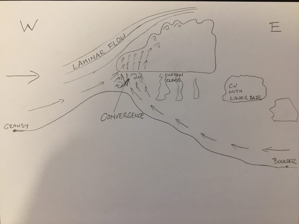
- “Wave” flying in laminar flow along a convergence line was a new experience for me. I’ll have to try this again when conditions look like this might be possible. It’s very cool! Calling it “wave” is probably wrong, as Alfonso Ossorio rightfully pointed out to me after the flight. Wave would suggest at least some repetition of an up and down airflow downstream. There is no evidence of that in this situation: there is only one convergence line and the laminar flow was just ahead of the upwind edge of the convergence, but it most likely did not propagate into an up and down motion further downwind. Also, the convergence line is not a classic wave trigger: the upwind motion isn’t caused by air getting pushed down (and heating up) prior to it moving up (and cooling down). It is most likely simply caused by the fact that the updraft along the convergence (which formed massive clouds today), is a massive obstacle for the prevailing winds aloft and they get rerouted above the obstacle that the convergence line poses. The flow is rougher down below the clouds (just like below rotor clouds), but it turns laminar in front of the convergence clouds (also just like it turns into laminar wave flow on the upwind side of rotor clouds.) Here’s a sketch of how I envision today’s scenario:
Great write up Clemens! Sounds like it was a memorable flight. I enjoyed the read, beautiful photos, and informative analysis of the conditions.
Thanks Blake! See you at the field.
Good sketch of the “Hydraulic Jump” and the laminar flow you experienced. Use it like wave but don’t let the NCAR gurus catch you calling it wave
Getting stuck on top is a serious potential in these conditions. Patients and timing may be the way home as you found. Benign spiral over the field is a last resort.
Good flight!
Thanks Al! My plan B was to land in Granby. When I descended below cloud base to get a good look at the sky towards Boulder, I did so at a point above the divide where I had the option to turn west over the mountains if the path to Boulder had been blocked. I don’t think that getting above the clouds and flying east above them in order to then benign-spiral down over Boulder would have been an option at all. The tops of the clouds were quite high, my guess is at least 25-30k feet, and continuing to rise as the storms were building. Trying to climb above them in Class A airspace would have been a nightmare. I was very clear in my mind that Granby was my escape if the route towards Boulder had been blocked. And the route to Granby was clear and safe at all times.